Carbonate rock dolomite content simulation method based on ground laser scanning
A technology of ground laser scanning and carbonate rock, which is used in the exploration of optical devices, design optimization/simulation, etc., to achieve the effect of good application prospects
- Summary
- Abstract
- Description
- Claims
- Application Information
AI Technical Summary
Problems solved by technology
Method used
Image
Examples
Embodiment Construction
[0058] In order to have a clearer understanding of the technical features, purposes and beneficial effects of the present invention, the technical solution of the present invention will be described in detail below in conjunction with the following specific examples, but it should not be construed as limiting the scope of the present invention.
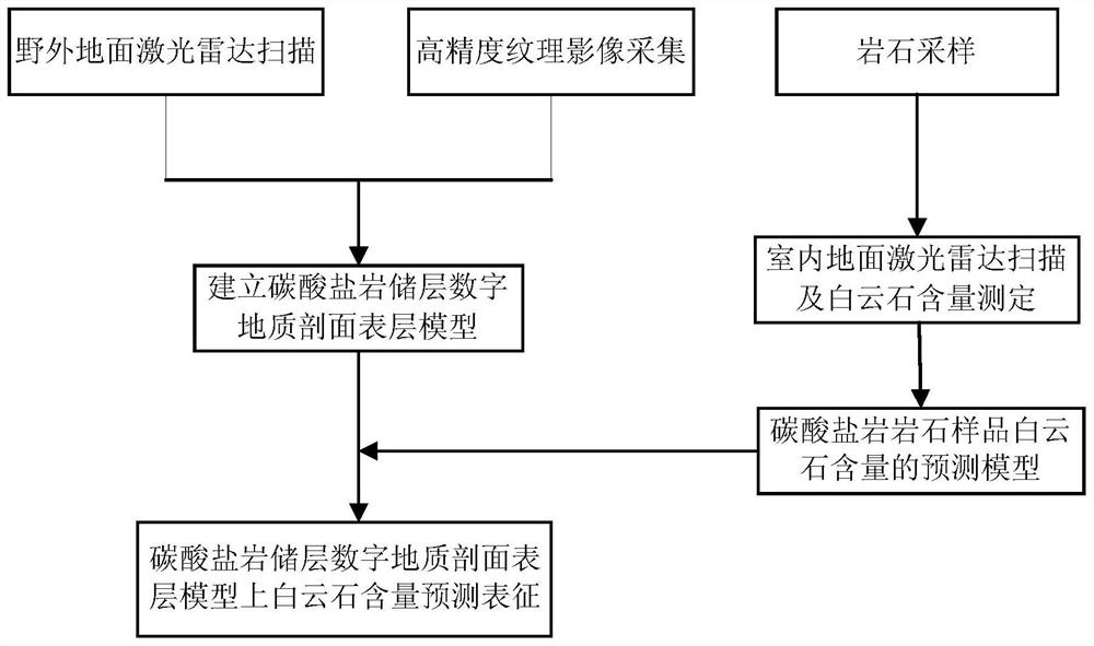
[0059] figure 1 The specific process flow diagram of the method for simulating the dolomite content of carbonate rocks based on ground laser scanning provided in this embodiment is shown, as figure 1 As shown, the method includes the following steps:
[0060] 1. Field geological profile data collection and rock sample sampling
[0061] The field geological profile data acquisition system includes a ground lidar scanner and a high-resolution digital camera. In this embodiment, the ground laser radar equipment selected is the Austrian rigel-vz400 ground laser radar scanner. In this embodiment, the ground laser radar scanner is used to...
PUM
 Abstract
Description
Claims
Application Information
 - R&D
- Intellectual Property
- Life Sciences
- Materials
- Tech Scout
- Unparalleled Data Quality
- Higher Quality Content
- 60% Fewer Hallucinations
Browse by: Latest US Patents, China's latest patents, Technical Efficacy Thesaurus, Application Domain, Technology Topic, Popular Technical Reports.
© 2025 PatSnap. All rights reserved.Legal|Privacy policy|Modern Slavery Act Transparency Statement|Sitemap|About US| Contact US: help@patsnap.com


