Low-altitude target tracking information fusion method and system based on multi-source detector

A low-altitude target and fusion method technology, applied in radio wave measurement systems, geographic information databases, digital data information retrieval and other directions, can solve the problems that radio detection and tracking equipment cannot meet the requirements of anti-interference and target recognition, and achieve advantages. The effect of complementing, improving reliability, and improving the accuracy of measurement

Pending Publication Date: 2021-02-09
BEIJING INST OF ENVIRONMENTAL FEATURES
View PDF6 Cites 5 Cited by
  • Summary
  • Abstract
  • Description
  • Claims
  • Application Information

AI Technical Summary

Problems solved by technology
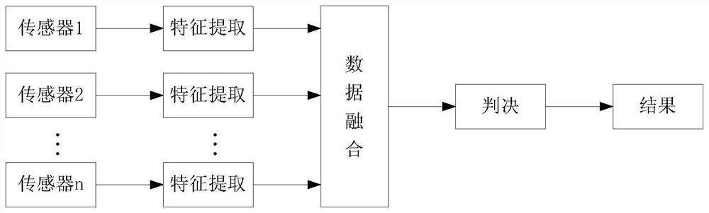
[0004] The technical problem to be solved by the present invention is to provide a low-altitude target tracking information fusion method and system based on multi-source detectors, which solves the problem of existing air target positioning, tracking and identification with radio interference, and radio detection and tracking equipment cannot achieve anti- Problems with Interference and Target Identification Requirements

Method used


Image

  • Low-altitude target tracking information fusion method and system based on multi-source detector
  • Low-altitude target tracking information fusion method and system based on multi-source detector
  • Low-altitude target tracking information fusion method and system based on multi-source detector

Examples


Embodiment 1

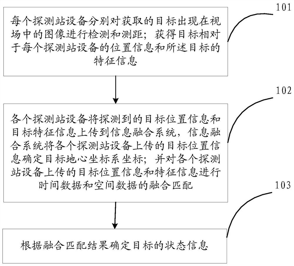
[0047] figure 1 It is a flowchart of a multi-source detector-based low-altitude target tracking information fusion method according to an embodiment of the present invention, and the method may include steps S101 to S103:

[0048] S101. Each detection station device detects and measures the acquired image of the target appearing in the field of view; obtains position information of the target relative to each detection station device and characteristic information of the target;

[0049] S102. Each detection station equipment uploads the detected target position information and target feature information to the information fusion system, and the information fusion system determines the coordinates of the target geocentric coordinate system from the target position information uploaded by each detection station equipment; and each detection station equipment The uploaded target location information and feature information are fused and matched with time data and spatial data; ...

Embodiment 2

[0076] An embodiment of the present invention provides a low-altitude target tracking information fusion system based on multi-source detectors, including: multiple detection station equipment and an information fusion system;

[0077] Each detection station device detects and measures the acquired image of the target appearing in the field of view; obtains the position information of the target relative to each detection station device and the characteristic information of the target;

[0078] Each detection station equipment uploads the detected target position information and target feature information to the information fusion system, and the information fusion system determines the coordinates of the target geocentric coordinate system from the target position information uploaded by each detection station equipment; and the uploaded by each detection station equipment Fusion and matching of time data and spatial data for target location information and feature information...

Embodiment 3

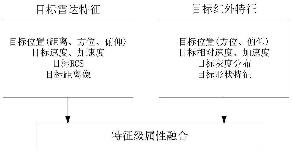
[0083] This embodiment takes the detection station equipment including photoelectric detection station equipment and radar detection equipment as an example to illustrate the low-altitude target tracking information fusion process based on multi-source detectors:

[0084] The photoelectric detection station equipment and radar are distributed in adjacent stations whose straight-line distance is not more than 10m and do not interfere with each other, and the position information LBH (longitude and latitude height) of the measuring station is obtained and converted into geocentric system coordinates S(x, y, z) , perform horizontal leveling and azimuth calibration on the detection equipment, and realize the network communication between the processing backends, which can transmit target detection information in real time and provide prerequisites for information fusion.

[0085] The photoelectric detection station equipment detects and segments the acquired image of the target app...


PUM


Abstract

The invention discloses a low-altitude target tracking information fusion method and system based on a multi-source detector. The method comprises the steps of enabling each detection station device to detect and measure the distance of an obtained image of a target appearing in a view field; obtaining position information of a target relative to each detection station device and feature information of the target; each detection station device uploads detected target position information and target feature information to an information fusion system, and the information fusion system determines a target geocentric coordinate system coordinate according to the target position information uploaded by each detection station device; fusion matching of time data and space data is carried out onthe target position information and the feature information uploaded by each detection station device; and the state information of the target is detected according to the fusion matching result. Themeasurement target information of the active detection station and the passive detection station is fused to realize advantage complementation, and the target accurate position information and the target type are obtained through information fusion calculation.

Description

technical field [0001] The invention relates to the technical field of target imaging information fusion, in particular to a multi-source detector-based low-altitude target tracking information fusion method and system. Background technique [0002] In recent years, drones have been appearing in people's sights. In addition to being widely used in the military, UAVs are also rapidly expanding in the civilian market. Civilian drones are not only widely used in aerial photography, but also in fields such as agriculture, forestry and plant protection, security law enforcement, environmental protection research, mineral resource exploration, disaster emergency rescue, oil pipeline inspection, border defense, and maritime patrol. According to incomplete statistics, there are hundreds of thousands of consumer-grade drones in China at present, showing a doubling growth trend every year. The rapid popularity of drones is bringing unprecedented challenges to the security work of var...

Claims


Application Information

Patent Timeline
Patent Type & Authority Applications(China)
IPC IPC(8): G06T7/70G06T7/292G06K9/00G06K9/62G06F16/29G06F16/245G01S13/86
CPCG06T7/70G06T7/292G06F16/29G06F16/245G01S13/86G06T2207/30232G06T2207/30241G06V20/52G06F18/25
Inventor 宋志蛟杨文佳黄建峰殷亚国李晓平
Owner BEIJING INST OF ENVIRONMENTAL FEATURES
Why Eureka
Try Eureka