Urban multi-source data-based street space quality measurement evaluation method and system

A multi-source data and evaluation method technology, applied in data processing applications, resources, character and pattern recognition, etc., can solve the problem of inaccurate street spatial measurement data, achieve refined measurement and control, improve accuracy, and broaden research range effect

Pending Publication Date: 2021-02-26
CHINA UNIV OF GEOSCIENCES (WUHAN)
View PDF6 Cites 15 Cited by
  • Summary
  • Abstract
  • Description
  • Claims
  • Application Information

AI Technical Summary

Problems solved by technology

[0007] The main purpose of the present invention is to provide a street space quality measurement and evaluation method and system based on urban multi-source data, which solves the technical problem of inaccurate street space measurement data in the prior art

Method used


Image

  • Urban multi-source data-based street space quality measurement evaluation method and system
  • Urban multi-source data-based street space quality measurement evaluation method and system
  • Urban multi-source data-based street space quality measurement evaluation method and system

Examples


Embodiment Construction

[0053] It should be understood that the specific embodiments described here are only used to explain the present invention, not to limit the present invention.

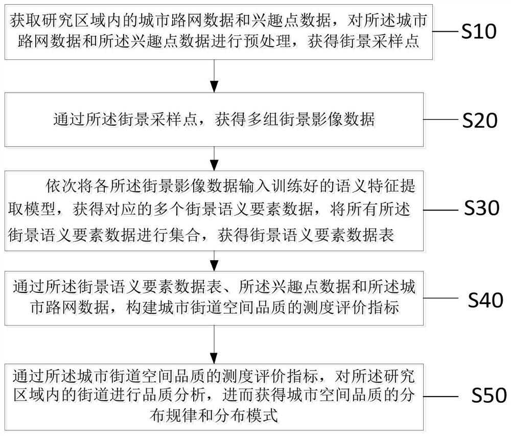
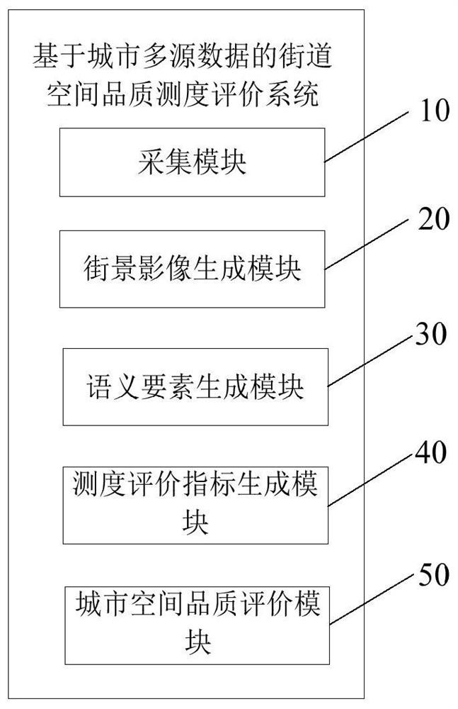
[0054] With the support of crowd-sourced geographic big data, the model-based method evaluates the quality of street space through scientific data analysis and big data mining methods, and provides an operable, scientific and reasonable space optimization model. Crowdsource geographic data has the advantages of large amount of data, strong current situation, abundant sources, and low cost. Based on the bottom-up collection characteristics of crowd-sourced geographic data, researchers can easily obtain city-wide, massive, and personal-based spatio-temporal information, so as to achieve fine geographic analysis and modeling, and provide better insights for the study of street functions. Serve.

[0055] The present invention is an extended application based on the deep learning model. On the basis of the previous space ...


PUM


Abstract

The invention relates to the field of urban planning, and provides an urban multi-source data-based street space quality measurement evaluation method, which comprises the following steps of: obtaining urban road network data and interest point data in a research area, and preprocessing the urban road network data and the interest point data to obtain street view sampling points; obtaining a plurality of groups of streetscape image data through streetscape sampling points; inputting each piece of streetscape image data into the trained semantic feature extraction model to obtain a streetscapesemantic element data table; constructing a measure evaluation index of the urban street space quality through a street view semantic element data table, the interest point data and the urban road network data; and obtaining the distribution rule and the distribution mode of the urban space quality through the measure evaluation index of the urban street space quality. According to the invention,the street quality is researched on the microcosmic scale, the research range is widened, research is carried out on the perspective of the urban macroscopic level, and the accuracy of street space quality measurement can be remarkably improved.

Description

technical field [0001] The invention relates to the field of urban planning, in particular to a method and system for measuring and evaluating street space quality based on urban multi-source data. Background technique [0002] In recent years, my country's urban construction is changing from incremental expansion to stock upgrading and optimization, and the quality of space is becoming an important part of planning and management. Therefore, in future urban construction, we will not only pay attention to incremental development, but also rationally plan and use stock resources. Philosophy is also very important. The focus of urban planning and construction has shifted from "growth priority" to "quality improvement", and gradually shifted from focusing on the speed of urban construction to focusing on the quality of urban development. With the popularization of information and communication technology and the emergence of geographic big data, many experts and scholars have g...

Claims


Application Information

Patent Timeline
Patent Type & Authority Applications(China)
IPC IPC(8): G06Q10/06G06K9/00G06K9/62G06Q50/26
CPCG06Q10/06393G06Q50/26G06V20/46G06V20/41G06F18/253G06F18/214
Inventor 王善霖吴亮张紫微胡胜
Owner CHINA UNIV OF GEOSCIENCES (WUHAN)
Why Eureka
Try Eureka