Multi-star map fused astronomical positioning method

An astronomical positioning and star map technology, which is applied in the field of astronomical positioning of multi-star map fusion, can solve the problems of reduced positioning accuracy, lack of regional star points, and inability to meet the precise positioning requirements of digital zenith instruments, and achieves high positioning accuracy. Effect

Inactive Publication Date: 2021-03-09
ROCKET FORCE UNIV OF ENG
View PDF6 Cites 9 Cited by
  • Summary
  • Abstract
  • Description
  • Claims
  • Application Information

AI Technical Summary

Problems solved by technology

However, the astronomical positioning method of the above-mentioned digital zenith instrument still has certain deficiencies in the positioning calculation. Due to the influence of factors such as the observation environment during shooting, there are regional star points missing in a small number of star maps. Making related corrections will lead to a decrease in the final positioning accuracy, which cannot meet the precise positioning requirements of the digital zenith instrument. Therefore, a multi-star map fusion astronomical positioning method is proposed

Method used


Image

  • Multi-star map fused astronomical positioning method
  • Multi-star map fused astronomical positioning method
  • Multi-star map fused astronomical positioning method

Examples


Embodiment Construction

[0040] The present invention is described in further detail now in conjunction with accompanying drawing.

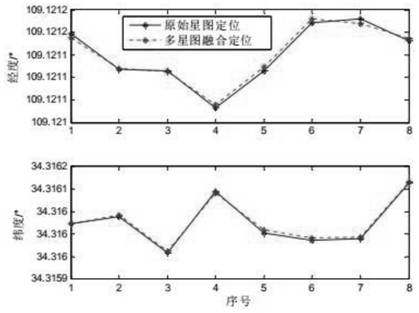
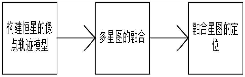
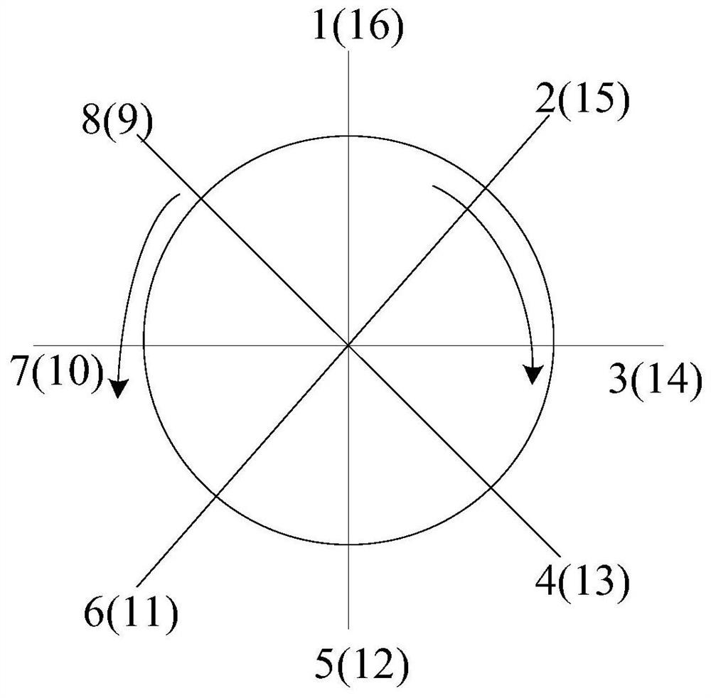
[0041] see figure 1 Summary of the invention: the present invention proposes a kind of astronomical positioning method of multi-star map fusion, comprises three steps of the location of the image point locus model of building star, multi-star map fusion, fusion star map. The working process of the digital zenith instrument is as follows: firstly, set up the digital zenith instrument at the position of the station, and perform rough and fine leveling through the leveling device on the digital zenith instrument; Figure; Next, use the star point centroid extraction algorithm with high precision and less time-consuming to get the barycenter coordinates of the star point on the CCD image plane coordinate system and identify and match these star points in the navigation star catalog, and then solve the astronomical coordinates pointed by the rotation axis Coordinates; Finally...


PUM


Abstract

The invention belongs to the technical field of astronomical navigation, and relates to a multi-star map fused astronomical positioning method. Experimental verification depends on a digital zenith instrument, and a hardware system of the digital zenith instrument comprises an optical imaging system, a high-precision inclinometer and a precision leveling device. The software system comprises starmap processing, zenith instrument positioning calculation and inclination angle compensation. The method is characterized by comprising three steps of fixed star image point track model construction,multi-star map fusion and fused star map positioning. Compared with the prior art, by adopting the method for positioning, when regional star point missing exists in a small number of star maps due tothe fact that star map shooting is affected by external uncertain factors, it can be guaranteed that the digital zenith instrument has high positioning precision through multi-star map fusion.

Description

technical field [0001] The invention belongs to the technical field of astronomical navigation, and relates to an astronomical positioning method for multi-star map fusion. Background technique [0002] The digital zenith instrument is developed from the analog zenith instrument. Its biggest feature is that it can accurately measure the astronomical position of the station. It is widely used in the field of geodesy and celestial navigation. Precision inclinometer, CCD sensitive components, etc. The University of Hannover in Germany first developed a portable zenith system, and then research institutes such as the Zurich Institute of Technology in Switzerland carried out related research one after another. Compared with foreign countries, domestic scientific research institutes are late in research on digital zenith instruments, but the development speed is relatively fast, which is mainly due to the substantial improvement in the industry's software and hardware levels. Th...

Claims


Application Information

Patent Timeline
Patent Type & Authority Applications(China)
IPC IPC(8): G01C21/02
CPCG01C21/02G01C21/025
Inventor 周召发张志利常振军刘先一段辉冯磊
Owner ROCKET FORCE UNIV OF ENG
Why Eureka
Try Eureka