A method for building road depth information model based on vehicle-mounted mobile laser point cloud

A laser point cloud and vehicle-mounted mobile technology, which is applied in 3D modeling, image analysis, image enhancement, etc., can solve the problems of large amount of calculation, blindness, and inaccurate extraction of three-dimensional position and attribute evaluation of diseases, so as to achieve accurate extraction results Effect

Active Publication Date: 2022-04-19
SHANDONG UNIV OF SCI & TECH
View PDF0 Cites 0 Cited by
  • Summary
  • Abstract
  • Description
  • Claims
  • Application Information

AI Technical Summary

Problems solved by technology

This method can effectively find most pavement diseases, but the disease discovery based on the current data is blind and requires a large amount of calculation; and this method cannot obtain road design status information, and the three-dimensional position and attribute evaluation of the extracted diseases are not accurate enough

Method used


Image

  • A method for building road depth information model based on vehicle-mounted mobile laser point cloud
  • A method for building road depth information model based on vehicle-mounted mobile laser point cloud
  • A method for building road depth information model based on vehicle-mounted mobile laser point cloud

Examples


Embodiment 1

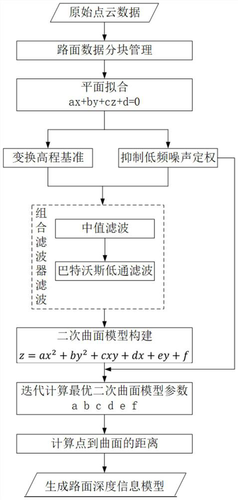
[0106] A road surface depth information model construction method based on vehicle-mounted mobile laser point cloud, such as Figure 1-6 shown, including the following steps:

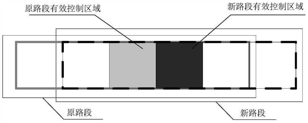
[0107] a. Divide single-lane independent road sections, the overlapping area of ​​two adjacent single-lane independent road sections is 4 / 5, and use single-lane independent road sections as data processing units for data processing;

[0108] The method of dividing single-lane independent road sections is as follows: in the direction of single-lane traffic, it is divided into several parts, and every 5 parts is a single-lane independent road section, and the overlapping area of ​​two adjacent single-lane independent road sections is 4 / 5. The width is the width of a single lane, about 3.5m, and the length and width of each portion are equal.

[0109] Such as figure 2 As shown, the adjacent two single-lane independent road sections are the original road section and the new road section respectively, and...

Embodiment 2

[0115] A method for building a road surface depth information model based on a vehicle-mounted mobile laser point cloud, as described in Embodiment 1, the difference is that step b includes the following sub-steps:

[0116] b1. Calculate the number of iterations according to the ratio relationship between the number n1 of points in the fitting plane and the number n of single-lane independent road section points and the success rate p:

[0117]

[0118] in, Interactive input in the form of a percentage, usually above 80%; p is the expected success rate of interactive input, usually above 90%, which can be determined according to the actual road conditions. The worse the road quality, the smaller the two input parameters, then k An estimate of the number of iterations required to achieve the above requirements;

[0119] Randomly select a three-point series of equations in the single-lane independent road section to solve the plane parameters, and then use the plane as a cons...

Embodiment 3

[0152] A method for building a road surface depth information model based on a vehicle-mounted mobile laser point cloud, as described in Embodiment 2, the difference is that step c includes the following sub-steps:

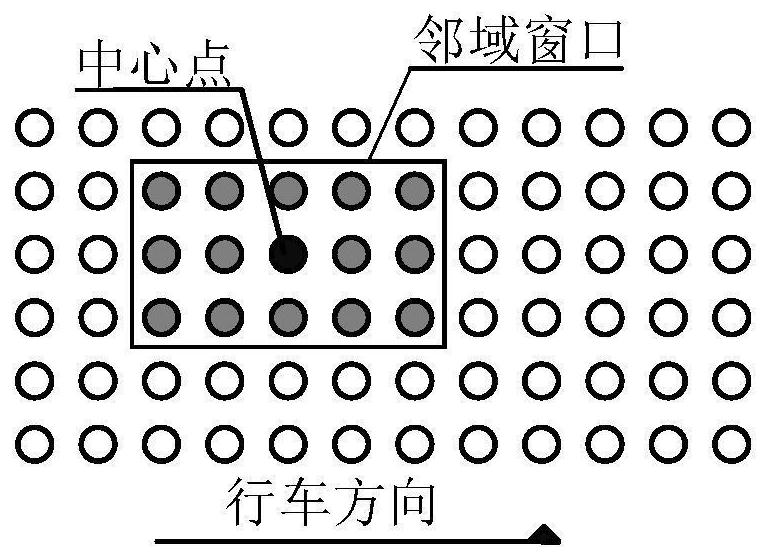
[0153] c1. Perform local median filtering on the road surface point cloud, specifically:

[0154] Use the K-D tree operator to search the neighborhood point set of the target point, and constrain the neighborhood range to a 5×3 long and narrow window distributed along the road direction, such as image 3 shown;

[0155] Sort the 15 points in the neighborhood window from small to large;

[0156] Replace the elevation value of the central point with the median elevation value of the 15 sorted points, and the local median filtering process of the single-lane segmented point cloud is as follows Image 6 shown;

[0157] c2. Perform global Butterworth low-pass filtering on the point cloud after median filtering:

[0158] For the statistical distribution of the relat...


PUM


Abstract

The invention relates to a method for constructing a road surface depth information model based on a vehicle-mounted mobile laser point cloud, which belongs to the technical field of road surface disease detection, and adopts a section division strategy with overlapping single lanes to control the road surface model. First, the RANSAC algorithm is used to obtain the consistent estimation plane of the single-lane road surface point cloud with a certain length, and the height of the original point cloud is normalized based on this plane; then, the combined filtering method of median filtering and Butterworth low-pass filtering is used to smooth Local high-frequency noise and global vibration noise on the road surface; finally, a quadratic surface model is constructed, and the filtered and smoothed vehicle-mounted mobile laser road surface point cloud is used as the observation value, and the iterative least squares fitting method that suppresses low-frequency features is used to obtain the quadratic surface parameters. Unbiased estimation value, using the continuous quadratic surface model as the standard road surface to calculate the distance from the discrete laser point to the surface to obtain the road surface depth information model. The present invention can restore the road surface structure more realistically, and construct the road surface depth information model.

Description

technical field [0001] The invention relates to a method for constructing a road surface depth information model based on a vehicle-mounted mobile laser point cloud, and belongs to the technical field of road surface disease detection. Background technique [0002] Due to the traffic load on the road and natural conditions, such as wind, rain, sunshine and other weathering erosion, the pavement will be plastically deformed or even damaged, which will further evolve into pavement diseases, which will reduce the overall strength of the pavement and affect driving comfort and safety. Moreover, this deformation accumulates over time, and when the deformation reaches a certain amount, the road design state cannot be restored according to the current road structure; collecting the current point cloud information of the road surface alone cannot accurately evaluate the road surface disease, which affects the accuracy of road quality change detection. [0003] At present, the measur...

Claims


Application Information

Patent Timeline
Patent Type & Authority Patents(China)
IPC IPC(8): G06T7/00G06T5/00G06T7/593G06T17/20
CPCG06T7/0002G06T5/002G06T7/593G06T17/20G06T2207/10028G06T2207/30256
Inventor 刘如飞柴永宁杨继奔王飞
Owner SHANDONG UNIV OF SCI & TECH
Why Eureka
Try Eureka