
Gravity satellite east-west direction differential observation data construction and inversion method and system

An observation data, east-west direction technology, applied in the field of gravity satellite east-west differential observation data construction and inversion, can solve the problem that cannot substantially reduce the measurement accuracy, observation mode and spatial resolution of the satellite flight orbit altitude accelerometer and other key loads Ratio north-south strip errors, space-time frequency aliasing and other problems, to achieve the effect of eliminating common errors, improving quality, and simple algorithm implementation

Pending Publication Date: 2021-03-19
中国人民解放军61540部队
View PDF0 Cites 1 Cited by
  • Summary
  • Abstract
  • Description
  • Claims
  • Application Information

AI Technical Summary

Problems solved by technology

Second, there is anisotropy problem of time-varying gravity field
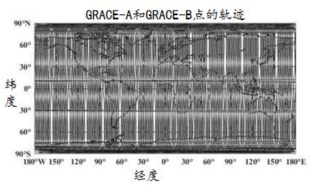
The GRACE satellite adopts the low-satellite tracking satellite observation mode in a near-polar circular orbit. The sub-satellite point trajectory presents the characteristics of dense orbits in the polar region and sparse orbits in the equatorial region. The inter-satellite distance variability observation value is the main observation quantity of the time-varying gravity field, resulting in This shows that the satellite is more sensitive to changes in the gravity field in the north-south direction, resulting in a north-south strip error
[0004] For the steady-state gravity field, the limitations of current gravity satellite missions are mainly reflected in the inability to substantially reduce the altitude of the satellite flight orbit and improve the measurement accuracy of the accelerometer and other key loads
For the time-varying gravity field, it mainly relies on the GRACE satellite mission to realize it. The main disadvantage is that the limitations of the observation mode and spatial resolution cause the north-south strip error and the aliasing of space-time frequency.

Method used


Image

  • Gravity satellite east-west direction differential observation data construction and inversion method and system
  • Gravity satellite east-west direction differential observation data construction and inversion method and system
  • Gravity satellite east-west direction differential observation data construction and inversion method and system

Examples


Embodiment 1

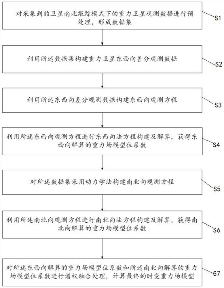
[0064] Such as figure 1 As shown, a gravity satellite east-west direction differential observation data construction and inversion method shown in this embodiment includes:

[0065] S1. Preprocessing the collected gravity satellite observation data under the satellite north-south tracking mode to form a data set.

[0066] Collect the gravity satellite observation data of one month under the satellite north-south tracking mode for preprocessing (including gross error elimination, error correction, time-space reference unification, interpolation filling and down-sampling, etc.), generate satellite orbit data, star sensor data, accelerometer measurement Data, KBR intersatellite rate variability data, form a high-precision data set.

[0067] S2. Using the data set to construct gravity satellite east-west differential observation data.

[0068] Specifically, constructing the gravity satellite east-west differential observation data includes:

[0069] S201 Calculate the average t...

Embodiment 2

[0258] Such as Figure 6 As shown, a gravity satellite east-west direction differential observation data construction and inversion system shown in this embodiment includes:

[0259] The data set acquisition module is used to preprocess the collected gravity satellite observation data under the satellite north-south tracking mode to form a data set;

[0260] The east-west differential observation data building module is used to construct the east-west differential observation data of the gravity satellite using the data set;

[0261] An east-west observation equation building block is used to construct an east-west observation equation using the east-west differential observation data;

[0262] The east-west method equation construction module is used to construct and solve the east-west method equation by using the east-west observation equation, and obtain the gravity field model potential coefficient of the east-west solution;

[0263]The north-south observation equation ...

Embodiment approach

[0273] As an optional implementation, the east-west observation equation construction module includes an east-west observation equation construction unit;

[0274] The east-west observation equation construction unit is used to use the satellite position, satellite average velocity and satellite non-conservative force average value in the east-west observation data to calculate the perturbation force acceleration and partial derivative of the corresponding point, using the perturbation force Acceleration and the east-west differential observation data, calculate the satellite acceleration residual, calculate the satellite acceleration differential residual, use the satellite acceleration differential residual, the partial derivative, and use the accelerometer bias, scale factor and gravity field model bit coefficient For the parameters to be estimated, construct the east-west observation equation based on the acceleration method.


PUM


Abstract

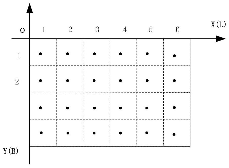
The invention relates to a gravity satellite east-west direction differential observation data construction and inversion method and system. The method comprises the following steps: carrying out datainterpolation and gridding processing on the basis of the observation data measured by a GNSS and the observation data of an accelerometer, carrying out difference processing on the positions, speedsand accelerations of a plurality of adjacent grid points in the east-west direction to obtain east-west differential observation data, further constructing an observation equation based on the east-west differential observation data, performing respective time-varying field calculation on north-south and east-west observation equations, finally performing spectral combination calculation on north-south and east-west gravitational field models, and calculating a final time-varying gravitational field model. The east-west observation data construction and inversion technology can effectively solve the problem of south-north stripes of a satellite inversion gravity field, thereby improving the gravitational field calculation precision. Compared with other methods, the algorithm provided by the invention is simple to implement, and the stability and reliability of the gravitational field calculation result can be ensured on the whole.

Description

technical field [0001] The invention relates to the field of satellite gravity field inversion, in particular to a method and system for constructing and inversion of gravity satellite east-west direction differential observation data. Background technique [0002] The earth's gravitational field is a basic physical field that reflects the distribution, movement, and mass change of the earth's matter. Accurately determining the fine structure of the earth's gravitational field and its temporal and spatial changes is of great importance in the fields of geophysics, geodesy, national defense science, and economic construction. practical value and significance. The use of satellites for gravity field detection is the most effective means to obtain high-quality gravity field models, and it has also become a hot technology for geospace detection. The main methods of retrieving the earth's gravity field using gravity satellite data are energy method, dynamic method and accelerati...

Claims


Application Information

Patent Timeline
Patent Type & Authority Applications(China)
IPC IPC(8): G01V7/00G01V7/06
CPCG01V7/00G01V7/06Y02A90/10
Inventor 肖云赵玉王丽兵刘晓刚
Owner 中国人民解放军61540部队
Learn More