Satellite navigation signal simulation method for low-orbit satellite as terminal carrier

A technology of satellite navigation signals and low-orbit satellites, which is applied in the field of satellite navigation, can solve problems such as inapplicability, and achieve the effects of convenient implementation, simple calculation, and ionospheric delay elimination

Pending Publication Date: 2021-04-02
SPACE STAR TECH CO LTD
View PDF0 Cites 2 Cited by
  • Summary
  • Abstract
  • Description
  • Claims
  • Application Information

AI Technical Summary

Problems solved by technology

Therefore, the GPSKlob, BDSKlob, and BDGIM models are not suitable f

Method used


Image

  • Satellite navigation signal simulation method for low-orbit satellite as terminal carrier
  • Satellite navigation signal simulation method for low-orbit satellite as terminal carrier
  • Satellite navigation signal simulation method for low-orbit satellite as terminal carrier

Examples


Embodiment Construction

[0053] Hereinafter, the present invention will be described in detail based on the drawings.

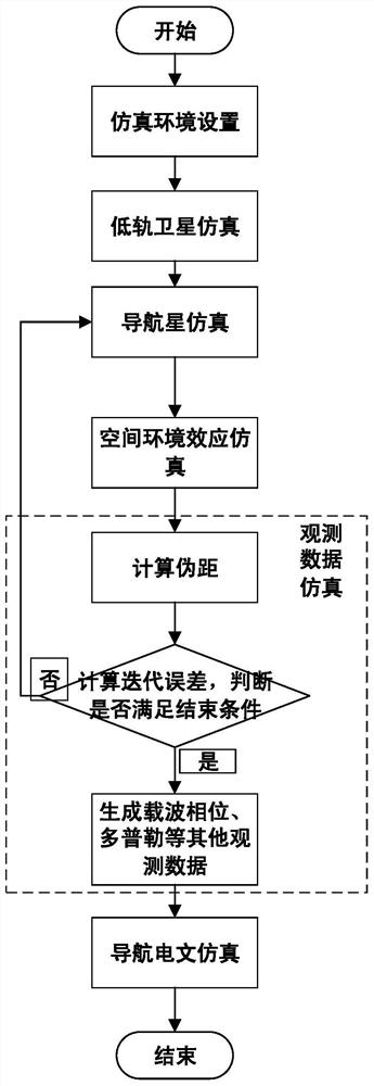
[0054] Such as figure 1 As shown, the satellite navigation signal simulation method for the terminal carrier of the present invention is a low-orbit satellite, and the specific steps are as follows:

[0055] (1) The simulation environment is set, including simulation time, ephemeris, clock difference, ionospheric parameters, low-orbit satellite carrier orbit point file, and the low-orbit satellite carrier orbit point file includes position, speed, Acceleration, jerk information.

[0056] (2) Generate the position of the low-orbit satellite carrier in the ECEF coordinate system (X u ,Y u ,Z u ).

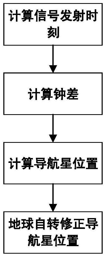
[0057] (3) According to the broadcast ephemeris parameters (namely ephemeris) of the set navigation constellation and the simulation time t, the signal transmission time is calculated, and the satellite position of the navigation star is (X s ,Y s ,Z s ), the specific steps are as ...


PUM


Abstract

The invention provides a satellite navigation signal simulation method for a low-orbit satellite as a terminal carrier, which comprises the steps of correspondingly improving a traditional ionospheremodel by considering the characteristics that the low-orbit satellite is positioned in the middle of an ionosphere and a navigation signal does not completely pass through the ionosphere on the basisof the traditional satellite signal simulation, and multiplying by a scaling factor highly correlated with the low-orbit satellite to obtain an ionosphere layer model suitable for the low orbit. Besides, the ionosphere model cannot completely represent the real ionosphere state, and only 60%-70% of real time delay can be corrected generally, so that the pseudo-range superimposed ionospheric erroris multiplied by a coefficient 1.3 to achieve a state closer to the actual state. When a navigation message is generated, ionosphere parameters are directly set. By means of the method, analogue simulation of satellite navigation signals received by the low-orbit satellite is achieved, and a testing tool is provided for a GNSS receiver carried by the low-orbit satellite and related systems.

Description

technical field [0001] The invention belongs to the field of satellite navigation, and relates to a satellite navigation signal simulation method aimed at a low-orbit satellite as a terminal carrier. Background technique [0002] The global satellite navigation and positioning system has the characteristics of global, all-weather, continuous and high precision. At present, it is widely used in land, ocean, aerospace and other fields. Low earth orbit (LEO) satellites (low earth orbit, LEO) are usually used in the fields of military detection and mobile communication due to their low orbit altitude, generally between 200 and 1000 km, with the characteristics of short transmission delay and small path loss. [0003] The atmosphere, usually about 70-1000 km above the ground, is called the ionosphere. As electromagnetic waves pass through the electron-filled ionosphere, their propagation speed and direction change, causing ionospheric delay errors in satellite navigation measur...

Claims


Application Information

Patent Timeline
IPC IPC(8): G01S19/20G01S19/23
CPCG01S19/20G01S19/23
Inventor 万程程邹国际马文聪蔡霞吉扬蕾张晓敏
Owner SPACE STAR TECH CO LTD
Why Eureka
Try Eureka