Vision-based indoor unmanned aerial vehicle path planning method

A path planning and unmanned aerial vehicle technology, applied in image analysis, image enhancement, navigation and other directions, can solve the problems of difficulty in obtaining a global map in advance, large amount of calculation, poor real-time performance, etc., to save memory overhead, strong real-time performance, and computational small amount of effect

Active Publication Date: 2021-05-04
NORTHWESTERN POLYTECHNICAL UNIV
View PDF12 Cites 16 Cited by
  • Summary
  • Abstract
  • Description
  • Claims
  • Application Information

AI Technical Summary

Problems solved by technology

[0003] Traditional path planning algorithms, such as RRT* algorithm and ant colony algorithm, often require a large amount of computation and poor real-time performance, so they are not suitable for platforms with weak computing power such as drones, while A*, Global path planning algorithms such as D* and the artificial potential field method usually have a corresponding bottleneck in the indoor environment because it is difficult to obtain a global map in advance.

Method used


Image

  • Vision-based indoor unmanned aerial vehicle path planning method
  • Vision-based indoor unmanned aerial vehicle path planning method
  • Vision-based indoor unmanned aerial vehicle path planning method

Examples


specific Embodiment

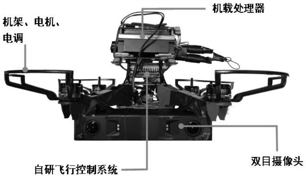
[0211] The platform adopted in the present invention is as attached image 3 As shown, the surrounding environment information is obtained through the binocular camera, the obstacle position is obtained through the onboard processor calculation and the safe flight trajectory of the drone is planned, and finally the self-developed flight control autopilot is used to make the drone fly safely according to the planned flight trajectory. Finally, the indoor autonomous flight mission was realized.

[0212] The present invention takes the indoor actual test flight as the result display, and the indoor task flow is as attached Figure 4 As shown, the artificially set main target points and their key orientations in this experiment include the target point ABCDE, where the dots of each color represent the position of the target point, and the arrows represent the target nose orientation corresponding to each target point. Target point A is the initial target point, which mainly reali...


PUM


Abstract

The invention discloses a vision-based indoor unmanned aerial vehicle path planning method, which comprises the following steps of: firstly, constructing a point cloud map, and then carrying out point cloud filtering and downsampling to improve the precision of the point cloud map; then constructing an octree map and an exploration map, and carrying out terrain value calculation; then planning a real-time path, finally forming an exploration map required by the real-time path planning through the construction of the map, and ensuring the correctness of a path planning algorithm through the conversion of the position and the path point of the unmanned aerial vehicle between a navigation coordinate system and an exploration map coordinate system; and finally, conducting real-time path smoothing. The method has the advantages of small calculation amount, high real-time performance, capability of unknown environment exploration and path planning at the same time and the like. Precise local path planning can be carried out in an explored area, and global path direction guidance can be carried out in an unexplored area; and rapid response to sudden obstacles can be realized.

Description

technical field [0001] The invention belongs to the technical field of drones, and in particular relates to a path planning method for drones. Background technique [0002] Traditional UAVs usually rely on artificially set flight waypoints and their virtual waypoints to achieve path planning and guidance in open outdoor areas. The ability to perform missions has put forward higher and higher requirements, and the path planning algorithm is a very important step in the process of UAV intelligence. Since the indoor environment is more complex than the outdoor environment, there are prominent technical problems such as difficulty in obtaining navigation maps in advance, narrow flight space, and many sudden obstacles. This kind of technical problem puts forward higher requirements for the real-time performance, re-planning ability of the path planning algorithm, and the security of the path. [0003] Traditional path planning algorithms, such as RRT* algorithm and ant colony a...

Claims


Application Information

Patent Timeline
Patent Type & Authority Applications(China)
IPC IPC(8): G01C21/00G06T7/50G06T7/73
CPCG01C21/005G06T7/50G06T7/73G06T2207/10028G06T2207/20024
Inventor 刘小雄黄剑雄高鹏程张兴旺梁晨
Owner NORTHWESTERN POLYTECHNICAL UNIV
Why Eureka
Try Eureka