Unmanned aerial vehicle navigation control system and method based on big data analysis

A control system and UAV technology, applied in the field of UAV navigation, can solve the problems of increased error accumulation and easy to receive interference.

Pending Publication Date: 2021-05-14
陈南方
View PDF0 Cites 8 Cited by
  • Summary
  • Abstract
  • Description
  • Claims
  • Application Information

AI Technical Summary

Problems solved by technology

[0002] Common methods of drone navigation include: inertial navigation, satellite navigation, integrated navigation, terrain-assisted navigation, and Doppler navigation. The navigation control system of drones is equivalent to the "eyes" of drones. The combination of multiple technologies is the future The direction of development, the navigation system of the UAV is responsible for providing the UAV with vector information such as the position, speed, and flight attitude of the reference coordinate system, and then guiding the UAV to fly according to the specified route, which is ...

Method used


Image

  • Unmanned aerial vehicle navigation control system and method based on big data analysis
  • Unmanned aerial vehicle navigation control system and method based on big data analysis

Examples


Embodiment Construction

[0027] The following will clearly and completely describe the technical solutions in the embodiments of the present invention with reference to the accompanying drawings in the embodiments of the present invention. Obviously, the described embodiments are only some, not all, embodiments of the present invention. Based on the embodiments of the present invention, all other embodiments obtained by persons of ordinary skill in the art without making creative efforts belong to the protection scope of the present invention.

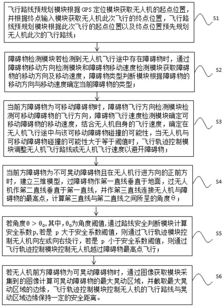
[0028] see Figure 1-2 , the present invention provides technical solutions:

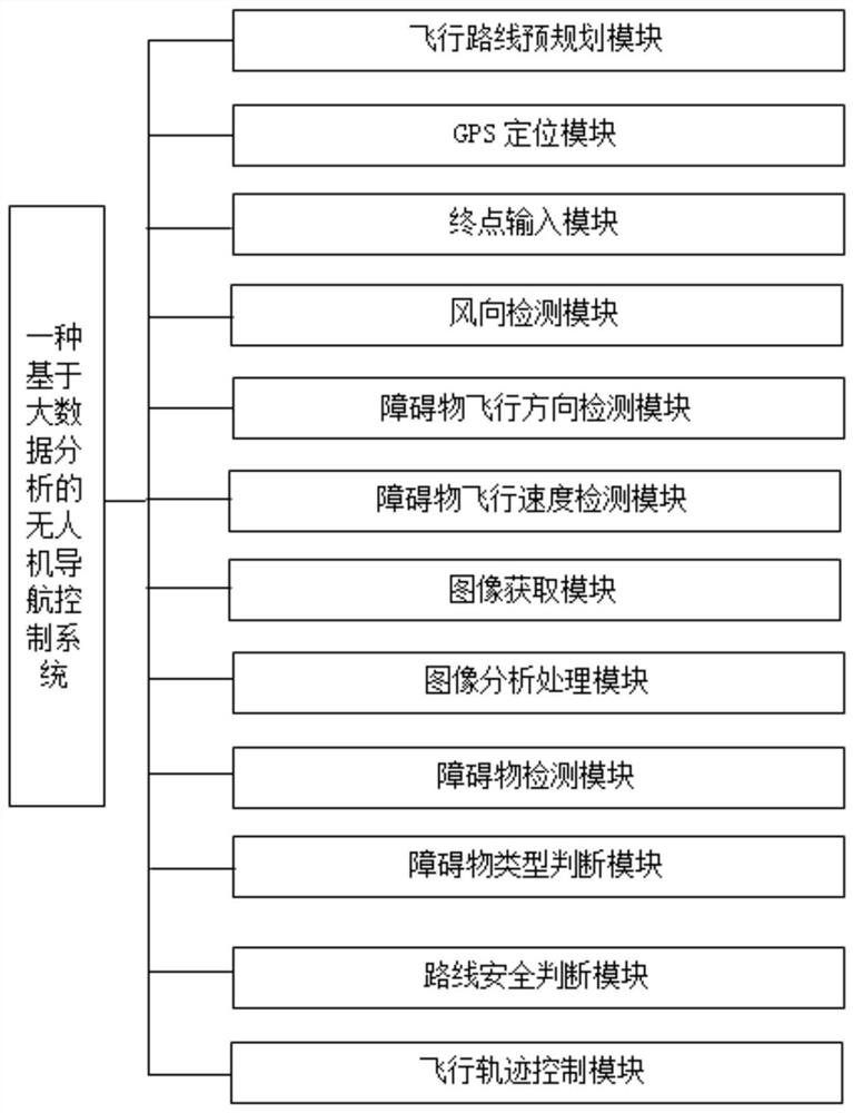
[0029] A UAV navigation control system based on big data analysis, including flight route pre-planning module, GPS positioning module, terminal input module, wind direction detection module, obstacle flight direction detection module, obstacle flight speed detection module, image acquisition module , image analysis and processing module, obstacle detection module, obstacle type jud...


PUM


Abstract

The invention discloses an unmanned aerial vehicle navigation control system and method based on big data analysis. The system comprises a flight route pre-planning module, a GPS positioning module, an end point input module, a wind direction detection module, an obstacle flight direction detection module, an obstacle flight speed detection module, an image acquisition module, an image analysis processing module, an obstacle detection module, an obstacle type judgment module, a route safety judgment module and a flight track control module. The system has the advantages that the flight route is preset according to the starting point position and the terminal point position of the unmanned aerial vehicle, in the flight process of the unmanned aerial vehicle, obstacles in a certain range in front are detected, the types of the obstacles are determined according to the moving direction and the moving speed of the obstacles, and different processing modes are selected according to the types of the obstacles; thus, the flight route of the unmanned aerial vehicle is adjusted, the flight efficiency of the unmanned aerial vehicle is improved, the flight safety of the unmanned aerial vehicle in the flight process is guaranteed, and the collision probability is reduced.

Description

technical field [0001] The invention relates to the field of unmanned aerial vehicle navigation technology, in particular to a system and method for unmanned aerial vehicle navigation control based on big data analysis. Background technique [0002] Common methods of drone navigation include: inertial navigation, satellite navigation, integrated navigation, terrain-assisted navigation, and Doppler navigation. The navigation control system of drones is equivalent to the "eyes" of drones. The combination of multiple technologies is the future The direction of development, the navigation system of the UAV is responsible for providing the UAV with vector information such as the position, speed, and flight attitude of the reference coordinate system, and then guiding the UAV to fly according to the specified route, which is equivalent to the navigator in the man-machine system , UAV navigation systems are mainly divided into two types: non-autonomous (GPS, etc.) and autonomous (i...

Claims


Application Information

Patent Timeline
IPC IPC(8): G05D1/10G01C21/20
CPCG05D1/101G01C21/20
Inventor 陈南方
Owner 陈南方
Why Eureka
Try Eureka