Remote sensing image semantic segmentation method based on parallel cavity convolution

A technology of remote sensing image and semantic segmentation, which is applied in the field of remote sensing image to achieve good pixel-level classification effect, expand the receptive field, and save video memory

Pending Publication Date: 2021-05-25
HUAZHONG UNIV OF SCI & TECH
View PDF12 Cites 4 Cited by
  • Summary
  • Abstract
  • Description
  • Claims
  • Application Information

AI Technical Summary

Problems solved by technology

These methods are all based on standard convolution, and the receptive field of standard convolution has limitations. Therefore, expanding the receptive field has important research and application value for semantic segmentation of remote sensing images.

Method used


Image

  • Remote sensing image semantic segmentation method based on parallel cavity convolution
  • Remote sensing image semantic segmentation method based on parallel cavity convolution
  • Remote sensing image semantic segmentation method based on parallel cavity convolution

Examples


Embodiment Construction

[0037] The technical solutions in the embodiments of the present invention will be clearly and completely described below with reference to the accompanying drawings in the embodiments of the present invention. Obviously, the described embodiments are only a part of the embodiments of the present invention, but not all of the embodiments. Based on the embodiments in the present invention, all other embodiments obtained by those of ordinary skill in the art fall within the protection scope of the present invention.

[0038] According to an embodiment of the present invention, a method for semantic segmentation of remote sensing images based on parallel hole convolution is provided.

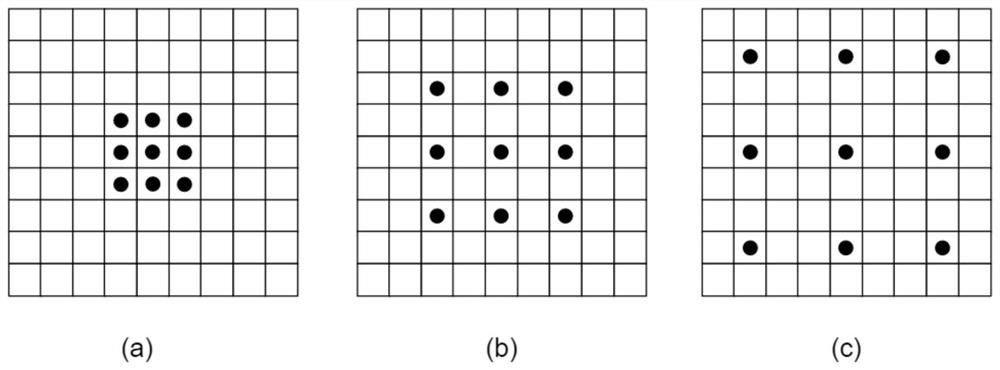
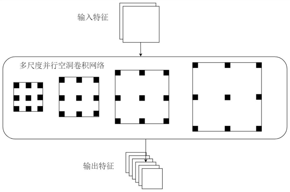
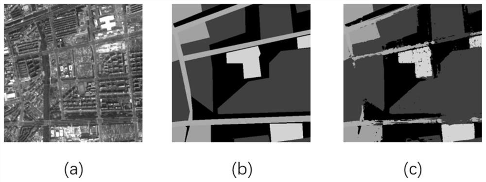
[0039] like Figure 1-Figure 3 As shown, the method for semantic segmentation of remote sensing images based on parallel hole convolution according to an embodiment of the present invention includes the following steps:

[0040] Acquire high-resolution remote sensing images in advance, and slice, ...


PUM


Abstract

The invention discloses a remote sensing image semantic segmentation method based on parallel cavity convolution, and relates to the technical field of remote sensing images, and the method comprises the following steps: obtaining a high-resolution remote sensing image in advance, and carrying out the slicing, normalization and standardization of the high-resolution remote sensing image, and obtaining a source high-resolution remote sensing image; initializing a low-layer network of a feature extraction network resnet101 based on a resnet101 parameter pre-trained on an ImageNet, constructing a parallel cavity convolutional network, and extracting a shallow-layer feature of a source high-resolution remote sensing image; inputting the shallow layer features into a parallel dilated convolutional network to obtain multi-scale information, and fusing the multi-scale information; and fusing the fused features with the shallow features again, and repairing image-level information by using a full-connection conditional random field to obtain a semantic segmentation result. Under the condition that extra parameters are not increased, the receptive field of convolution is expanded, and compared with standard convolution achieving the same receptive field, the parallel cavity convolution method can save more video memories.

Description

technical field [0001] The invention relates to the technical field of remote sensing images, in particular to a method for semantic segmentation of remote sensing images based on parallel hole convolution. Background technique [0002] With the maturity of satellite remote sensing technology, the advancement of commercialization, and the encouragement and promotion of governments around the world, satellite remote sensing has developed rapidly and has been applied in more and more fields. Semantic segmentation of remote sensing images is an important part of satellite remote sensing applications. Semantic segmentation of remote sensing images is widely used in urban planning, road planning, object extraction, and even pattern recognition in autonomous driving. Improving the accuracy of semantic segmentation is of great significance in the processing of remote sensing images. [0003] The ground object information in remote sensing images is complex and diverse. In order t...

Claims


Application Information

Patent Timeline
Patent Type & Authority Applications(China)
IPC IPC(8): G06T7/10G06K9/62G06N3/08G06T5/30G06T5/50
CPCG06T7/10G06T5/30G06T5/50G06N3/08G06T2207/10032G06T2207/20081G06T2207/20084G06T2207/20221G06T2207/10024G06F18/241G06F18/253
Inventor 张东映唐振超罗蔚然洪志明梁忠壮刘震
Owner HUAZHONG UNIV OF SCI & TECH
Why Eureka
Try Eureka