Debris flow disaster early warning method based on landform information entropy and rainfall

A technology for debris flow and rainfall, which is applied in forecasting, alarms, resources, etc., can solve the problems of single early warning model indicators and inability to fully reflect landform information, and achieve the effect of high early warning accuracy

Pending Publication Date: 2021-05-28
CHINA RAILWAY SIYUAN SURVEY & DESIGN GRP
View PDF4 Cites 11 Cited by
  • Summary
  • Abstract
  • Description
  • Claims
  • Application Information

AI Technical Summary

Problems solved by technology

Therefore, the existing early warning methods for debris flow disasters, the early warning model indicators based on trigger factor i...

Method used


Image

  • Debris flow disaster early warning method based on landform information entropy and rainfall
  • Debris flow disaster early warning method based on landform information entropy and rainfall
  • Debris flow disaster early warning method based on landform information entropy and rainfall

Examples


Embodiment 1

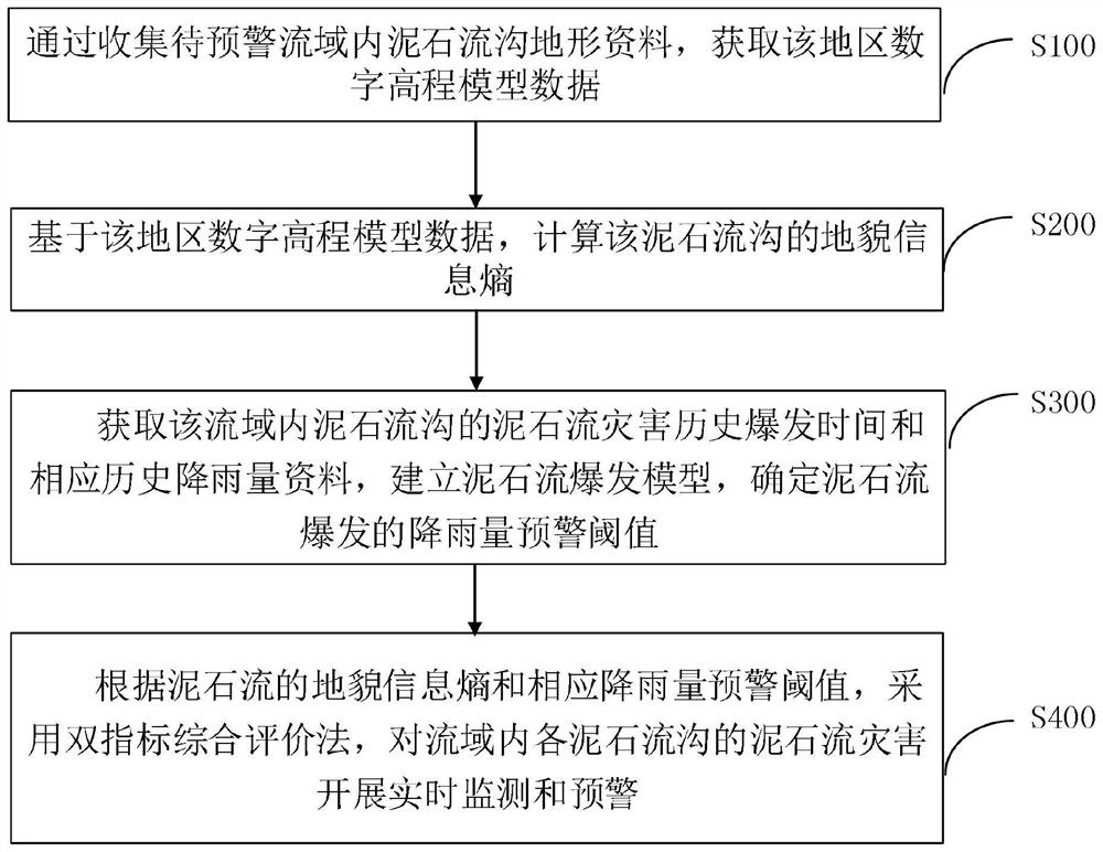
[0035]The present invention discloses a method based on debris flow disaster prevention method based on geomorphological information entropy and rainfall, such asfigure 1 ,include:

[0036]S100. A digital elevation model data is acquired by collecting mudstone terrain in the warning basin.

[0037]S200. Based on the number of digital elevation model data, the landform information entropy of the debris flow ditch is calculated. Specifically, in this embodiment, the specific method of S200 is:

[0038]S201. Use the digital elevation model data acquired to determine its basin area, import it into the ArcGIS software;
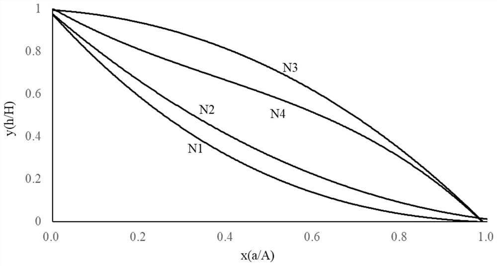
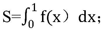
[0039]S202. According to the area of ​​the river basin, the area A above a contour line in this basin, the high difference H of the lowest point in the basin, and the maximum relative high difference H in the basin is a series of at the right angle coordinate axis. X = A / A and Y = H / H composition points to fit, to obtain an area-elegant integrated curve y = f (x), the area-elega...

Embodiment 2

[0059]In order to better, in the following, the mudstone gave ditch in the Niufu River Basin in Yunnan Province, such asfigure 2 N1, N2 mudslide and N3, N4 mudslide is located in the Niufu River Basin, Yunnan Province, N1, N2 mudslide located in the north bank of Niu Konghe, N1 watershed area 0.19km2, N2 watershed area 0.17km2These two mudslide grooves are stable, no newly stacked fan production, the stability of the debris gantou, high vegetation coverage, basic non-deposits in the river, low burst of mudslides, no eruption records in recent years; N3, N4 mudslide Located in the south shore of Niu Kong, N3 mudslide basin area 0.15km2, N4 mudslide basin area 0.14km2These two mudslide grooves are stacked, and the stacked fans are gradually expanding. The mainstream of the front edge of the N4 mudslide is obviously crushed. There are a large amount of gravel accumulation in the river. The groove can be seen a large amount of stuffing stone, mudslide outbreak High frequency.

[0060]Calcu...


PUM


Abstract

A debris flow disaster early warning method based on landform information entropy and rainfall comprises the following steps: acquiring digital elevation model data of a region by collecting debris flow gully topographic data in a drainage basin to be early warned; calculating the landform information entropy of the debris flow gully based on the digital elevation model data of the region; obtaining historical debris flow disaster outbreak time and corresponding historical rainfall data of the debris flow gullies in the drainage basin, establishing a debris flow outbreak model, and determining a rainfall early warning threshold value of debris flow outbreak; and according to the landform information entropy of the debris flow and the corresponding rainfall early warning threshold value, carrying out real-time monitoring and early warning on the debris flow disaster of each debris flow gully in the drainage basin by adopting a double-index comprehensive evaluation method. According to the method, on the basis of the landform information entropy of the debris flow gully, the landform factors and the rainfall factors are combined, the problem that in a traditional early warning method, early warning is conducted with induction factors as main indexes, and topographic element indexes are not considered is solved, and compared with the prior art, the debris flow disaster early warning accuracy is higher.

Description

Technical field[0001]The present invention relates to the field of disaster monitoring and early warning, and more particularly to mudslide disaster prevention methods based on geomorphological information entropy and rainfall.Background technique[0002]At present, there have been some patents based on rainfall, such as patent CN106652361A, which disclose a mudflow warning method based on rainfall-probability, which is based on the critical rainfall of mudslides based on the conditional probability theory of mudslide. The calculation of the experiment, theoretical calculation, and the probability of rainfall conditions, realizing the construction method of the early warning index system in combination with the probability of mudslide uncertainty and rainfall in the formation of mudslide formation.[0003]Patent CN110148284A discloses a mudslide warning method based on rainfall, which is to install a rainfall monitoring station near the mudslide, and then determine the critical value of...

Claims


Application Information

Patent Timeline
IPC IPC(8): G06Q10/04G06Q10/06G06Q50/26G08B21/10
CPCG06Q10/04G06Q10/063114G06Q10/0635G06Q50/265G08B21/10Y02A90/10
Inventor 李浩陈爱云秦绍清朱孟君王哲柏威伟张云明付敬宏杨可雄
Owner CHINA RAILWAY SIYUAN SURVEY & DESIGN GRP
Why Eureka
Try Eureka