Satellite navigation dynamic multi-path real-time correction method and device and computing equipment

A satellite navigation and multi-path technology, applied in the field of global satellite navigation, can solve the problems of computing efficiency and positioning performance to be improved, and achieve the effect of improving observation accuracy and positioning accuracy

Pending Publication Date: 2021-06-04
BEIJING UNIV OF CIVIL ENG & ARCHITECTURE
View PDF2 Cites 0 Cited by
  • Summary
  • Abstract
  • Description
  • Claims
  • Application Information

AI Technical Summary

Problems solved by technology

These processing methods, computational efficiency and positioning performance need to be improved

Method used


Image

  • Satellite navigation dynamic multi-path real-time correction method and device and computing equipment
  • Satellite navigation dynamic multi-path real-time correction method and device and computing equipment
  • Satellite navigation dynamic multi-path real-time correction method and device and computing equipment

Examples


Embodiment Construction

[0022] It should be understood that the specific embodiments described here are only used to explain the present invention, not to limit the present invention.

[0023] In the following description, use of suffixes such as 'module', 'part' or 'unit' for denoting elements is only for facilitating description of the present invention, and has no specific meaning by itself. Therefore, 'module', 'part' or 'unit' may be used in combination.

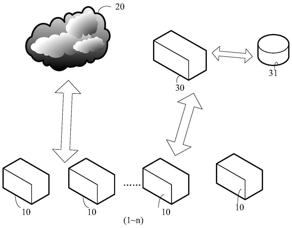
[0024] figure 1 It is a hardware schematic diagram of an implementation mode of the satellite navigation dynamic multi-path real-time correction system of the embodiment of the present application, as shown in figure 1 As shown, the system includes a vehicle navigation system 10 , a satellite navigation positioning system 20 and a computing device 30 .

[0025] In some embodiments, a plurality of car navigation systems 10 are distributed in various locations on urban roads, figure 1 1 to n in. The multiple vehicle navigation systems 10 may...


PUM


Abstract

The invention relates to a satellite navigation dynamic multi-path real-time correction method and device and computing equipment, and the method comprises the steps: receiving a first satellite signal collected by a current fixed star calendar through a vehicle-mounted navigation positioning system in real time; based on a corresponding relation between second satellite signals of multiple positions of a previous fixed star calendar at multiple moments and multi-path error correction values of the second satellite signals, utilizing weekly-day repetitive matching to obtain multi-path error correction values corresponding to the first satellite signals; based on the first satellite signals, collected by the current fixed star calendar, of the multiple positions at the multiple moments, calculating multi-path error correction values of the corresponding positions at the corresponding moments through a multi-path calculation model; and storing a corresponding relation between the first satellite signals of the plurality of positions of the current fixed star calendar at the plurality of moments and the multipath error correction values of the first satellite signals so as to determine the multipath error correction value corresponding to a third satellite signal acquired by the next fixed star calendar in real time. The method improves the calculation efficiency.

Description

technical field [0001] The present application relates to the technical field of global satellite navigation, in particular to a satellite navigation dynamic multi-path real-time correction method, device and computing equipment. Background technique [0002] The global satellite navigation system can provide global users with all-weather, continuous real-time, high-precision three-dimensional position and three-dimensional velocity information, and has the advantages of not accumulating errors over time. However, it also has disadvantages such as poor autonomy, susceptibility to interference, poor accuracy in application environments with occlusions, and low receiver data update frequency, making it difficult to meet the requirements of real-time navigation in complex environments. [0003] In an urban environment, multipath error is a source of error that cannot be ignored because satellite signals are reflected multiple times due to the influence of tall buildings, overpa...

Claims


Application Information

Patent Timeline
Patent Type & Authority Applications(China)
IPC IPC(8): G01S19/22G01S19/37G01S19/40
CPCG01S19/22G01S19/37G01S19/40
Inventor 韩厚增刘培原王坚
Owner BEIJING UNIV OF CIVIL ENG & ARCHITECTURE
Why Eureka
Try Eureka