Satellite navigation high-precision relative positioning method based on ranging information assistance

A satellite navigation and relative positioning technology, which is applied in the field of satellite navigation relative positioning, can solve problems such as increased computation, complex algorithm implementation, and complex models, and achieve the effects of small computing resources, simple algorithm model, and increased computation

Pending Publication Date: 2021-06-18
NO 20 RES INST OF CHINA ELECTRONICS TECH GRP
View PDF0 Cites 1 Cited by
  • Summary
  • Abstract
  • Description
  • Claims
  • Application Information

AI Technical Summary

Problems solved by technology

However, due to the increase in the number of satellites, the amount of calculation has increased sharply, and it involves the detection and identification of multi-satellite navigation observation faults, the algorithm implementation is more complicated; the method of multi-frequency point combination uses multiple observations of different frequency points in a single system The combined observations are generated by linear combination to fix the ambiguity. Although the ambiguity fixing performance is greatly improved, it is necessary to solve the single-frequency ambiguity fixed solution step by step, and the operation is complicated.
Moreover, it is necessary to consider the problem of algorithm switching when a certain frequency point or multiple frequency points in multiple frequency points are missing, and the algorithm logic is complex
The above two methods do not need to introduce external information, but the reliability of satellite navigation relative positioning calculation cannot be guaranteed when the satellite navigation signal is blocked or the geometric configuration is degraded.
The inertial navigation assistance method uses the short-term high-precision characteristics of inertial navigation to assist the relative positioning calculation of satellite navigation, which can greatly improve the reliability of satellite navigation relative positioning, but the cost of inertial navigation system is high and the model is relatively complicated.

Method used


Image

  • Satellite navigation high-precision relative positioning method based on ranging information assistance
  • Satellite navigation high-precision relative positioning method based on ranging information assistance
  • Satellite navigation high-precision relative positioning method based on ranging information assistance

Examples


Embodiment Construction

[0040] The present invention will be further described below in conjunction with the accompanying drawings and embodiments.

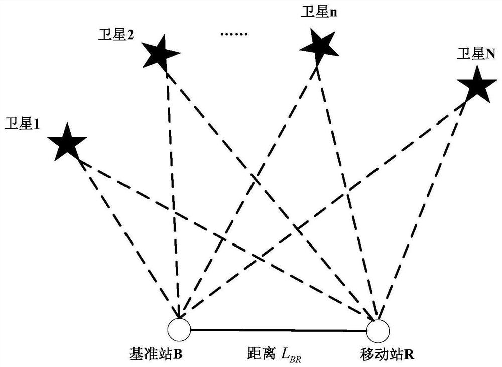
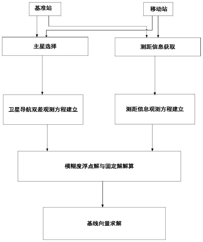
[0041] The present invention is a method for monitoring the integrity of a satellite navigation and landing system using fixed baseline vectors between multiple reference receiver antennas in a ground reference station as constraint information. The specific steps are as follows: figure 2 Shown:

[0042] Step 1: Main star selection

[0043] The overall block diagram of the method of satellite navigation high-precision relative positioning based on ranging information is as follows: figure 1 As shown, select a satellite in the common-view satellite set Q (a total of L satellites) of the base station B and the mobile station R as the main star, denoted as M; in order to ensure that the selected M main star has better data quality, it is required that the M star The carrier-to-noise ratio is the largest among all common-view satellites and the elevation...


PUM


Abstract

The invention provides a satellite navigation high-precision relative positioning method based on ranging information assistance. The method comprises the following steps of selecting a primary satellite, establishing a satellite navigation double-difference observation equation, acquiring ranging information, establishing a ranging information observation equation, solving a baseline vector after an ambiguity floating solution and a fixed solution and completing satellite navigation relative solution. According to the method, the ranging information is introduced, strong constraint information of the distance between the base station and the mobile station is provided for satellite navigation relative positioning, and the reliability of satellite navigation relative positioning can still be guaranteed by using the information when the number of satellites is insufficient or the geometric configuration is poor. The method provided by the invention is simple in algorithm model, has no obvious increase in operand compared with the original algorithm, and occupies less operation resources. A ranging information error model is simple, complex modeling is not needed, and implementation is easy.

Description

technical field [0001] The invention relates to the field of satellite navigation relative positioning, and relates to a satellite navigation high-precision relative positioning method assisted by ranging information in a satellite navigation relative positioning system. Background technique [0002] In surveying and mapping, precision agriculture and other high-precision relative positioning applications, relative positioning based on satellite navigation pseudo-range observations has low precision and cannot meet its high-precision positioning requirements, so it must rely on real-time dynamic relative positioning technology based on satellite navigation carrier phase . In the real-time dynamic relative positioning technology based on satellite navigation carrier phase, the mobile station uses the satellite navigation observation information provided by the reference station and combines its own observation information to perform double difference calculation. At the same...

Claims


Application Information

Patent Timeline
Patent Type & Authority Applications(China)
IPC IPC(8): G01S19/51G01S19/25G01S19/28G01S19/29G01S19/44G01S19/45G01S19/41
CPCG01S19/258G01S19/28G01S19/29G01S19/41G01S19/44G01S19/45G01S19/51
Inventor 原彬李洋蔡悟洋庄皓玥冯泽
Owner NO 20 RES INST OF CHINA ELECTRONICS TECH GRP
Why Eureka
Try Eureka