Laser mileage calculation method based on point cloud multi-view projection drawing

A projection map and multi-view technology, applied in the field of laser odometer, can solve the problem of loss of local feature information of point cloud, and achieve the effect of overcoming the loss of accuracy, efficient operation, and strong portability

Active Publication Date: 2021-06-22
UNIV OF SCI & TECH OF CHINA
View PDF11 Cites 1 Cited by
  • Summary
  • Abstract
  • Description
  • Claims
  • Application Information

AI Technical Summary

Problems solved by technology

Therefore, when feature extraction is performed on point clouds, only features whose order is unchanged can be extracted. At present, the common practice is to use maxpooling to extract the global features of point clouds, but this leads to the loss of local feature information of point clouds.

Method used


Image

  • Laser mileage calculation method based on point cloud multi-view projection drawing
  • Laser mileage calculation method based on point cloud multi-view projection drawing
  • Laser mileage calculation method based on point cloud multi-view projection drawing

Examples


Embodiment Construction

[0042] The technical solutions in the embodiments of the present invention will be clearly and completely described below in conjunction with the accompanying drawings in the embodiments of the present invention. Obviously, the described embodiments are only part of the embodiments of the present invention, not all of them. Based on the embodiments of the present invention, all other embodiments obtained by persons of ordinary skill in the art without making creative efforts belong to the protection scope of the present invention.

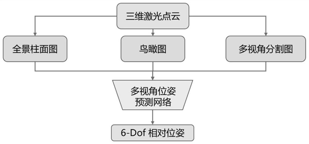
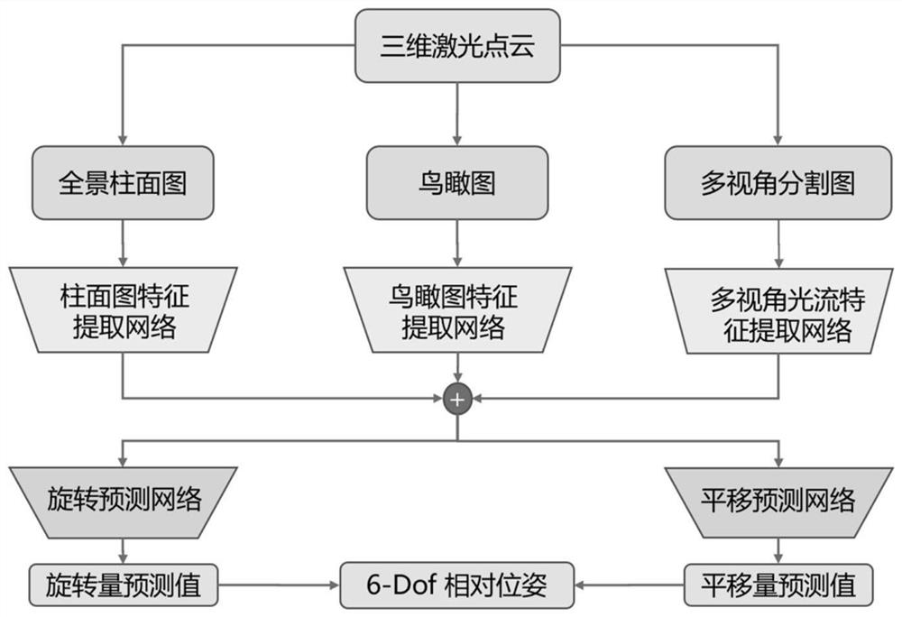
[0043] According to the embodiments of the present invention, in order to overcome the defects in the existing technical solutions, a laser mileage calculation method based on three-dimensional point cloud multi-view projection is proposed for complex traffic scenes and mobile robot platforms. This algorithm fully considers the cost and To meet the requirements of precision, a robust, low-cost, and high-precision mileage calculation method is design...


PUM


Abstract

The invention provides a laser mileage calculation method based on a point cloud multi-view projection drawing, and the method is applied to a mobile robot and an automatic driving platform, and comprises the following steps: 1, carrying out multi-view two-dimensional projection on three-dimensional laser point cloud data to obtain a cylindrical panoramic projection view and an aerial view of an environment, and further segmenting the projection to obtain a multi-view point cloud projection drawing; 2, constructing a multi-view pose estimation network, and extracting environmental geometric structure features on the point cloud projection drawing; 3, calculating a pose loss function based on a pose absolute value and a luminosity reprojection error loss function based on a stable point region; 4, training a neural network model according to the pose loss function, wherein the neural network model can estimate relative pose transformation according to the input point cloud data of the front and back frames.

Description

technical field [0001] The invention relates to the field of mobile robot technology and automatic driving, in particular to the field of deep learning methods and laser odometers in the framework of SLAM (Synchronous Positioning and Mapping). Background technique [0002] With the improvement of manufacturing technology and the increasing attention paid to safety issues, lidar has great application potential in cutting-edge applications such as autonomous driving and unmanned logistics. Therefore, a series of 3D vision tasks based on laser point cloud target detection, semantic segmentation, odometry, and relocalization have become research hotspots in related fields. However, due to the disorder and sparsity of laser point cloud, the following problems need to be solved before it can be widely used in the field of unmanned driving and robotics: [0003] 1) In a traffic scene, one scan data of 64-line lidar contains 10 ^5 Any point-by-point retrieval operation will cause ...

Claims


Application Information

Patent Timeline
Patent Type & Authority Applications(China)
IPC IPC(8): G06T7/215G06T7/246G06T7/269G06N3/04G06N3/08
CPCG06T7/215G06T7/246G06T7/269G06N3/08G06T2207/10028G06T2207/20081G06T2207/20084G06N3/045
Inventor 陈宗海裴浩渊王纪凯戴德云徐萌林士琪
Owner UNIV OF SCI & TECH OF CHINA
Why Eureka
Try Eureka