
Remote sensing identification method and system suitable for crop types in landscape fragmentation area

A technology for remote sensing recognition and broken areas, applied in neural learning methods, character and pattern recognition, biological neural network models, etc., can solve the problems of CNN model limitations, simple structure, etc., achieve good visual effects, and the trend of accuracy changes is small , the effect of high recognition accuracy

Active Publication Date: 2021-06-25
北京艾尔思时代科技有限公司
View PDF5 Cites 3 Cited by
  • Summary
  • Abstract
  • Description
  • Claims
  • Application Information

AI Technical Summary

Problems solved by technology

[0007] In view of the above situation, the present invention proposes a method and system suitable for remote sensing identification of crop types in landscape fragmented areas, which can solve the shortcomings of traditional classification methods and the limitations of CNN models with simple structure and single module in land fragmented areas

Method used


Image

  • Remote sensing identification method and system suitable for crop types in landscape fragmentation area
  • Remote sensing identification method and system suitable for crop types in landscape fragmentation area
  • Remote sensing identification method and system suitable for crop types in landscape fragmentation area

Examples


Embodiment Construction

[0052] Exemplary embodiments of the present disclosure will be described in more detail below with reference to the accompanying drawings. Although exemplary embodiments of the present disclosure are shown in the drawings, it should be understood that the present disclosure may be embodied in various forms and should not be limited by the embodiments set forth herein. Rather, these embodiments are provided for more thorough understanding of the present disclosure and to fully convey the scope of the present disclosure to those skilled in the art.

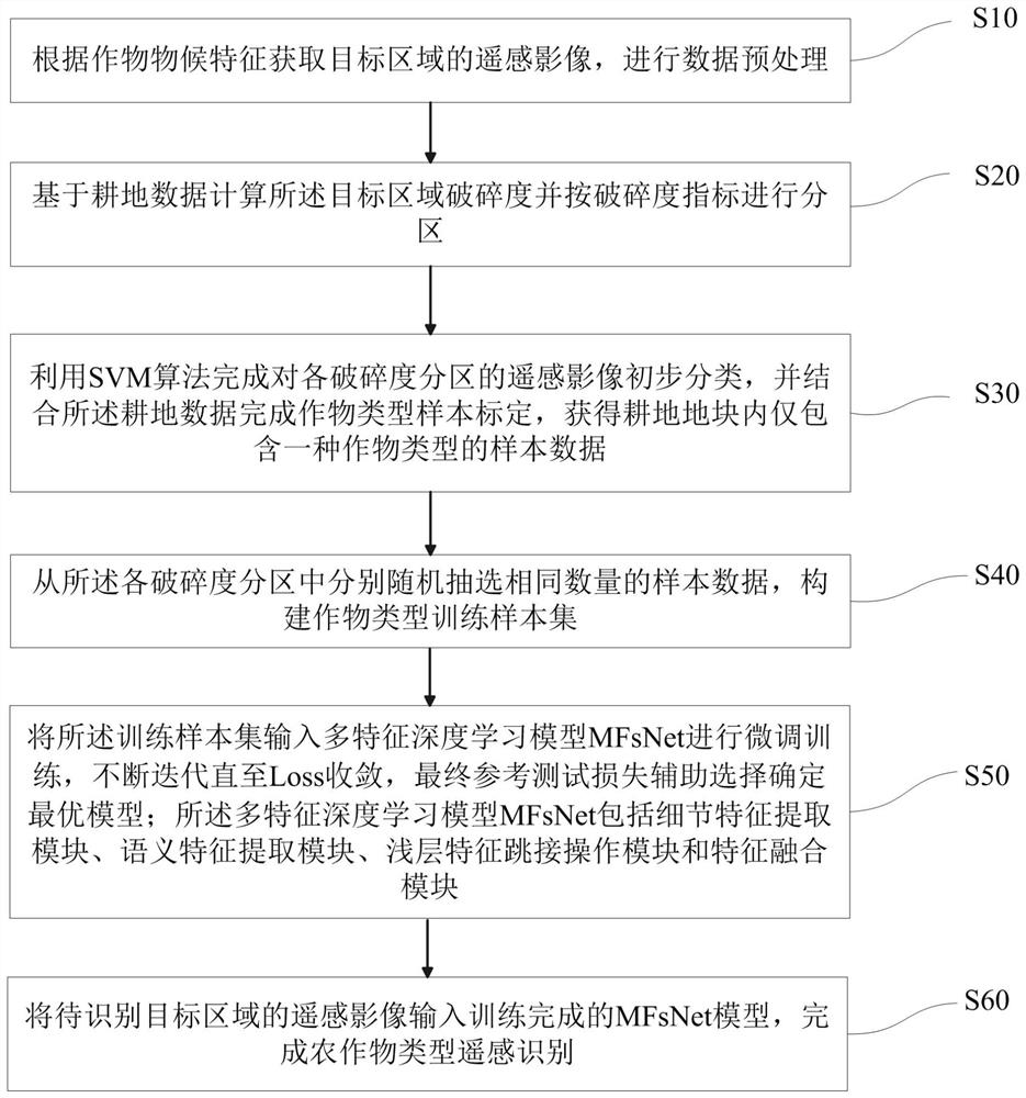
[0053] The invention provides a method suitable for remote sensing identification of crop types in landscape broken areas, such as figure 1 As shown, wherein, the method includes:

[0054] S10: Obtain remote sensing images of the target area according to the phenological characteristics of the crops, and perform data preprocessing;

[0055] S20: Calculate the fragmentation degree of the target area based on the cultivated land dat...


PUM


Abstract

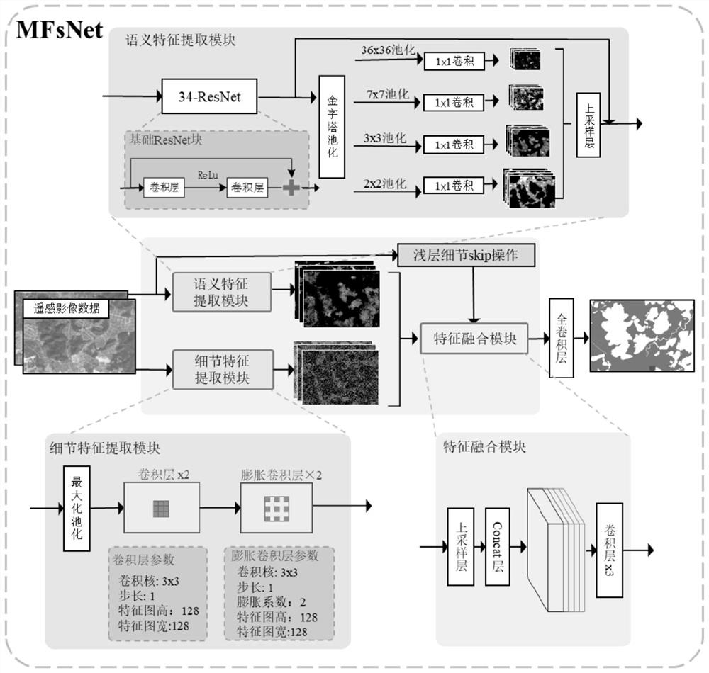
The invention discloses a remote sensing identification method and system suitable for crop types in a landscape fragmentation area, and the method comprises the steps: obtaining a remote sensing image of a target area according to the phenological characteristics of crops, and carrying out the data preprocessing; calculating the crushing degree of the target area based on the cultivated land data and partitioning; combining cultivated land data and crop distribution data obtained through SVM algorithm identification to construct a sample set; randomly selecting a training sample set and a test set from each fragmentation subarea, and inputting the training sample set and the test set as samples to a multi-feature deep learning model MFsNet comprising a detail feature extraction module, a semantic feature extraction module, a shallow feature jump operation module and a feature fusion module to complete the construction of a crop identification model; and inputting the to-be-identified target area image into the model to obtain a crop type identification result. According to the method, the training samples are selected from the partitions with different fragmentation degrees, so that the representativeness of the training samples is ensured, and the model training result can realize relatively high crop type identification precision in the landscape fragmentation area.

Description

technical field [0001] The invention belongs to the technical field of remote sensing image processing and crop type identification, in particular to a method and system suitable for remote sensing identification of crop types in landscape fragmentation areas. Background technique [0002] Based on the advantages of short detection period, large coverage, and strong current potential, remote sensing technology can support accurate and rapid identification of crop types. The process of distinguishing different crops and other types of ground objects. The extraction of remote sensing recognition and classification methods and features will directly affect the accuracy of crop recognition, requiring a large amount of manual intervention, such as manual feature extraction, which is difficult to achieve automatic classification; it is difficult to extract deep-level features, and the extracted features are all low-level A single or a small number of shallow features, resulting i...

Claims


Application Information

Patent Timeline
Patent Type & Authority Applications(China)
IPC IPC(8): G06K9/00G06K9/62G06N3/04G06N3/08
CPCG06N3/08G06V20/188G06N3/048G06N3/045G06F18/241
Inventor 梁治华丁志平朱爽
Owner 北京艾尔思时代科技有限公司
Learn More