
Memory, and control method and device for airborne laser radar system

An airborne laser radar and control method technology, applied in the field of geographic information, can solve problems affecting positioning accuracy, large errors, poor pitch and heading correction effects, etc., and achieve the effect of improving measurement accuracy

Pending Publication Date: 2021-07-16
CHINA PETROLEUM & CHEM CORP +1
View PDF0 Cites 2 Cited by
  • Summary
  • Abstract
  • Description
  • Claims
  • Application Information

AI Technical Summary

Problems solved by technology

[0004] In order to eliminate the installation angle error, in many commercial laser data processing software; such as Optech, the cross-track method is commonly used; this method can estimate the installation angle in the roll direction very well; but the correction effect on pitch and heading is not good ; As a result, the error is large and affects the positioning accuracy

Method used


Image

  • Memory, and control method and device for airborne laser radar system
  • Memory, and control method and device for airborne laser radar system
  • Memory, and control method and device for airborne laser radar system

Examples


Embodiment Construction

[0058] The specific embodiments of the present invention will be described in detail below in conjunction with the accompanying drawings, but it should be understood that the protection scope of the present invention is not limited by the specific embodiments.

[0059] Unless expressly stated otherwise, throughout the specification and claims, the term "comprise" or variations thereof such as "includes" or "includes" and the like will be understood to include the stated elements or constituents, and not Other elements or other components are not excluded.

[0060] In this document, for the convenience of description, spatially relative terms, such as "below", "below", "lower", "above", "above", "upper", etc., may be used to describe the relationship between one element or feature and another. The relationship of elements or features in the drawings. It will be understood that the spatially relative terms are intended to encompass different orientations of the item in use or o...


PUM


Abstract

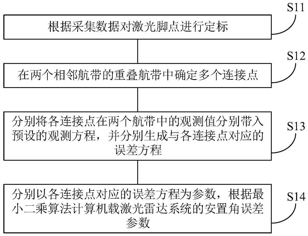
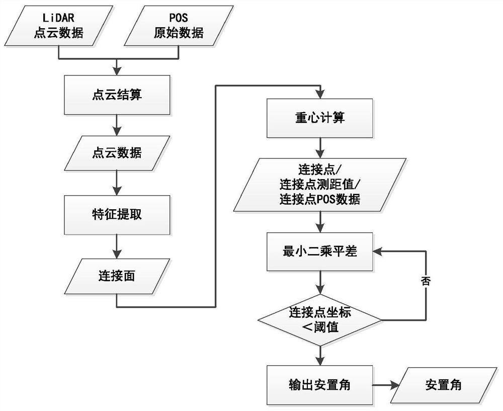
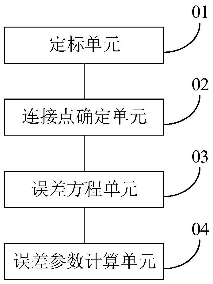
The invention discloses a memory, and a control method and device for an airborne laser radar system. The method comprises the following steps of: calibrating a laser foot point according to the spatial position information of an unmanned aerial vehicle acquired by a GPS, the attitude information of the unmanned aerial vehicle in space measured by an IN, the distance from a laser emission point to the laser foot point and an angle of a laser beam measured by a laser scanner, and the acquired data of a placement error of the system; determining a plurality of connection points in an overlapped air strip of the two adjacent air strips; respectively substituting the observation values of the connection points in the two air strips into a preset observation equation, and respectively generating error equations corresponding to the connection points; and calculating a placement angle error parameter of the onboard laser radar system according to a least square algorithm by taking the error equation corresponding to each connection point as a parameter. According to the memory, the control method and the control device, the placement angle error can be accurately obtained, so that the overall measurement precision of the system can be improved.

Description

technical field [0001] The invention relates to the technical field of geographical information, in particular to a memory, a control method and a device for an airborne laser radar system. Background technique [0002] Airborne lidar (also known as airborne LiDAR measurement system) is a tight integration of laser ranging equipment, GNSS equipment, INS and other equipment, using the flight platform as a carrier, and recording the attitude, position and reflection intensity of the target by scanning the ground and other information, obtain the three-dimensional information of the surface, and in-depth processing to obtain the required spatial information technology. [0003] In the process of ground positioning of the airborne LiDAR measurement system, its accuracy will be affected by various system errors from ranging, angle measuring, positioning, and integration. The research shows that the installation angle error in the integrated error is the largest system error sour...

Claims


Application Information

Patent Timeline
Patent Type & Authority Applications(China)
IPC IPC(8): G01S7/48G01S7/497
CPCG01S7/4802G01S7/497
Inventor 王晓霖王佳楠石磊李明黄梓健
Owner CHINA PETROLEUM & CHEM CORP
Learn More