
Full-automatic approaching landing monitoring method for military and civil aviation airport

A fully automatic, civil aviation technology, applied in the direction of reflection/re-radiation of radio waves, use of re-radiation, measurement devices, etc., can solve the problems of unintuitive system display, limited support capability, and increase the risk of aircraft landing, and achieve intuitive display. and clear effect

Active Publication Date: 2021-07-20
THE 28TH RES INST OF CHINA ELECTRONICS TECH GROUP CORP
View PDF10 Cites 0 Cited by
  • Summary
  • Abstract
  • Description
  • Claims
  • Application Information

AI Technical Summary

Problems solved by technology

The existing airport approach and landing surveillance methods and systems have the following disadvantages: (1) Civil aviation airports rely on broadcast automatic dependent surveillance system equipment, and military aviation airports rely on landing radars to monitor landing routes, with single surveillance methods and insufficient information and automation levels; (2) The controller uses binoculars to visually observe the flight attitude of the aircraft during the landing stage and the retractable state of the landing gear. The duty pressure is high, and the system display is not intuitive; (3) In bad weather conditions (such as haze, night and other visibility weather) , the support capability is limited, which increases the landing risk of the aircraft

Method used


Image

  • Full-automatic approaching landing monitoring method for military and civil aviation airport
  • Full-automatic approaching landing monitoring method for military and civil aviation airport
  • Full-automatic approaching landing monitoring method for military and civil aviation airport

Examples


Embodiment Construction

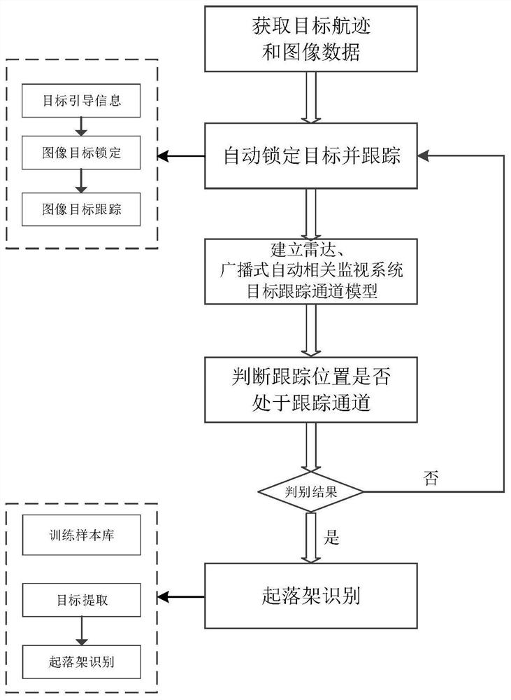
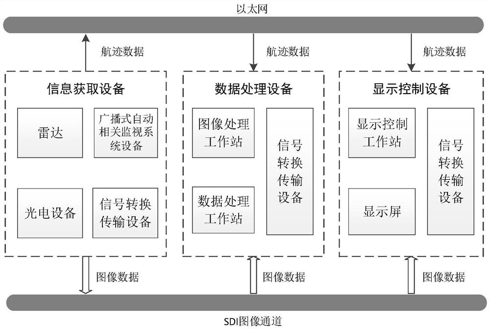
[0071] Such as figure 1 , figure 2 , The present invention provides a military civil airport landing approach automatic monitoring method comprising the steps of:

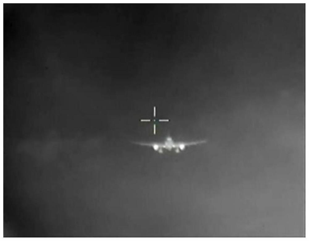
[0072] (1) track and a photoelectric image data acquisition target, such as Figure 3A Indicated;

[0073] Radar track data comprises target azimuth, elevation, distance and secondary code;

[0074] Automatic dependent surveillance-broadcast output device longitude, latitude, altitude, secondary code (5707) and the destination address code information (FF085D91), transferred by geographical coordinates spherical coordinates, to obtain the target track data, including azimuth, elevation, distance information secondary code 5707;

[0075] Target track data optoelectronic device comprises azimuth, elevation, distance, size, gradation and other information.

[0076] (2) According to the data track, photovoltaic device is automatically locked boot target, based on the image data in real time with high precision tracking begi...


PUM


Abstract

The invention provides a full-automatic approaching landing monitoring method for a military and civil aviation airport, which is used for meeting user requirements of visual guidance and full-automatic monitoring in an approaching landing stage of an airplane and comprises the following steps: 1) acquiring a track and image data of a target; 2) guiding a photoelectric device to automatically lock a target according to the track data, and starting real-time high-precision tracking based on image data; 3) establishing a target tracking channel model of the radar and broadcast type automatic correlation monitoring system; 4) judging whether the image tracking position is in a target tracking channel, and if so, continuing tracking; otherwise, returning to the step 2; and 5) according to the image tracking position, calculating a target area, and using the deep convolutional neural network to identify the folding and unfolding state of the target undercarriage.

Description

Technical field [0001] The present invention belongs to the field of multi-source information processing, in particular, involving a process of automatic in-landing monitoring methods for military civil aviation airports. Background technique [0002] Air traffic control is used to prevent the aircraft from colliding with aircraft, aircraft and obstacles collision, achieving the purpose of maintaining and accelerating aerial traffic, including tower control, access to regional control. Regional control guarantees route flight safety; tower control and approachable control mainly guarantee flight safety during the aircraft. [0003] At present, military and civilian airports are mainly configured in the II blind system, a small number of large civil aviation airports (Capital Airport, Guangzhou Baiyun Airport, Shanghai Pudong Airport, etc.) have II-type blind system, mainly including pointing beacons, MLS (microwave landing System), ILS (instrument landing system), Tacan (Tacon), ...

Claims


Application Information

Patent Timeline
IPC IPC(8): G01S13/86G01S13/72G01S7/41
CPCG01S7/415G01S7/417G01S13/72G01S13/86G01S13/867
Inventor 白俊奇刘文石林陈平苗锋孙宜斌章林朱伟
Owner THE 28TH RES INST OF CHINA ELECTRONICS TECH GROUP CORP
Learn More