Geographic position searching method and device, electronic equipment and storage medium

A technology of geographical location and search method, which is applied in the field of automatic program design, can solve the problems of slow response, difficulty in meeting real-time query requirements, low efficiency, etc., and achieve the effect of improving user experience, increasing query speed, and reducing query volume

Pending Publication Date: 2021-07-20
CHINA CONSTRUCTION BANK
View PDF0 Cites 1 Cited by
  • Summary
  • Abstract
  • Description
  • Claims
  • Application Information

AI Technical Summary

Problems solved by technology

This method, if the data points are relatively sparse and involves a large-scale search of hundreds or even thousands of kilometers, is inefficient and slow to respond to real-time query requirements; if the data points are very dense, the block contains There are a lot of data points, which greatly exceeds the single-page display capacity of the display page, and there is a problem of a large number of redundant calculations

Method used


Image

  • Geographic position searching method and device, electronic equipment and storage medium
  • Geographic position searching method and device, electronic equipment and storage medium
  • Geographic position searching method and device, electronic equipment and storage medium

Examples


Embodiment 1

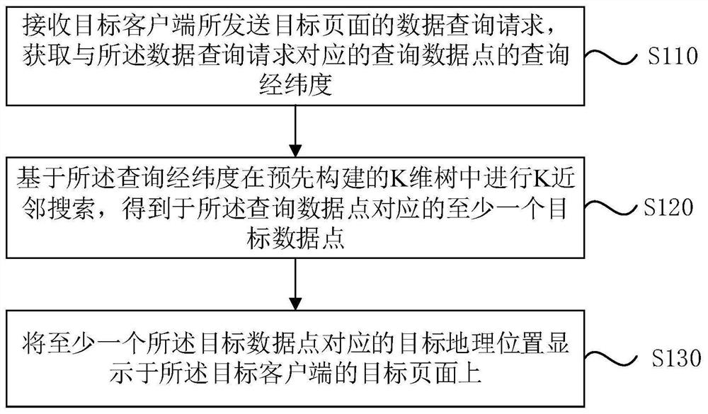
[0027] figure 1 It is a schematic flow chart of a geographical location search method provided by Embodiment 1 of the present invention. This embodiment is applicable to the situation of searching a geographic location. The method can be executed by a geographic location search device. The device can pass implemented by software and / or hardware.

[0028] Such as figure 1 As shown, the method in this embodiment may specifically include the following steps:

[0029] S110. Receive the data query request of the target page sent by the target client, and acquire the query latitude and longitude of the query data point corresponding to the data query request.

[0030] Among them, the query data point needs to calculate its nearest neighbor position point. In the embodiment of the present invention, the query data point can be understood as the geographic location of the query request. The geographic location of the query data point can be represented by the query latitude and lo...

Embodiment 2

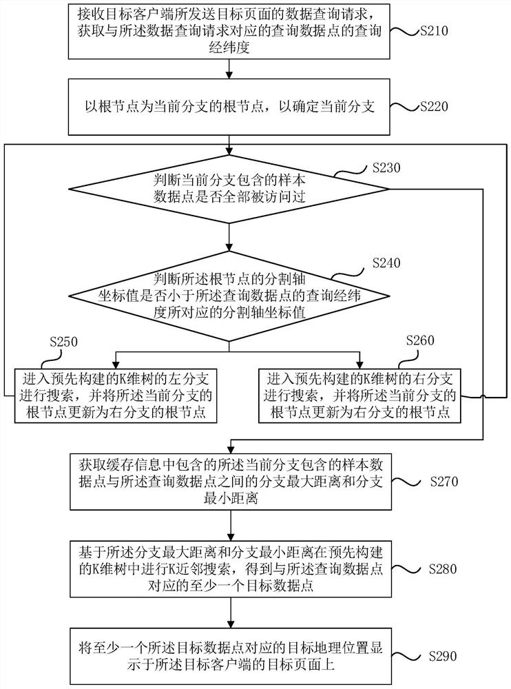
[0070] figure 2 It is a schematic flowchart of a geographical location search method provided in Embodiment 2 of the present invention. This embodiment is based on any optional technical solution in the embodiment of the present invention. Optionally, the query based on the latitude and longitude Carry out K-nearest neighbor search in the pre-built K-dimensional tree, including: taking the root node as the root node of the current branch to determine the current branch; judging whether all the sample data points contained in the current branch have been visited; if the samples contained in the current branch If all the data points have not been visited, it is judged whether the split axis coordinate value of the root node is less than the split axis coordinate value corresponding to the query latitude and longitude of the query data point; if so, enter the left side of the pre-built K-dimensional tree branch to search, and update the root node of the current branch to the roo...

Embodiment 3

[0107] This embodiment provides an optional example of performing geographic location search based on the geographic location search method in the embodiment of the present invention. Its specific implementation process is as follows:

[0108] 1. Create a data index

[0109] Before K-dimensional tree (K-Dimensional tree, KDTree) is used for K-neighborhood search, it is necessary to establish a data index based on KDTree. Specifically can include:

[0110] 1) Convert latitude and longitude to Cartesian coordinate system

[0111] Obtain the data latitude and longitude (lon, lat) of each sample data point collected, convert the data latitude and longitude (lon, lat) into the data point coordinates (x, y, z) of the spatial Cartesian coordinate system, and based on the following formula Convert the latitude and longitude of the data into the data point coordinates of the spatial Cartesian coordinate system:

[0112] lon=lon / 180*π

[0113] lat=lat / 180*π

[0114] x=R*cos(lat)*c...


PUM


Abstract

The embodiment of the invention relates to the technical field of automatic programming, and discloses a geographic position searching method and device, electronic equipment and a storage medium. The method comprises the following steps of receiving a data query request, sent by a target client, of a target page, and obtaining query longitude and latitude of a query data point corresponding to the data query request, based on the query longitude and latitude, conducting K-nearest neighbor search in a pre-constructed K-dimensional tree, acquiring at least one target data point corresponding to the query data point, wherein the K-dimensional tree is constructed based on the data longitude and latitude of each sample data point, and displaying the target geographic position corresponding to the at least one target data point on a target page of the target client. According to the technical scheme provided by the embodiment of the invention, the K-nearest neighbor search is carried out in the pre-constructed K-dimensional tree, so that not only is the distance range not limited, but also the query quantity can be reduced, the query speed can be improved, the client request can be responded more quickly, and the user experience can be improved.

Description

technical field [0001] The embodiments of the present invention relate to the technical field of automatic program design, and in particular to a geographical location search method, device, electronic equipment and storage medium. Background technique [0002] At present, banks have a large number of outlets, employees, equipment, customers, etc. across the country. In terms of business, they need to query specific objects across the country according to the latitude and longitude of the designated location, and sort them from near to far. On the client side Visual display provides data support for resource scheduling and decision-making. [0003] The existing technology is based on dividing the map into small blocks of basically the same size, and then calculating the block to which each data point belongs. When querying, first find out all the data points in the block where the query data point is located, and then query the outer block layer by layer. This method, if t...

Claims


Application Information

Patent Timeline
Patent Type & Authority Applications(China)
IPC IPC(8): G06F16/29G06F16/909G06F16/9537G06F16/901
CPCG06F16/29G06F16/9027G06F16/909G06F16/9537
Inventor 周康
Owner CHINA CONSTRUCTION BANK
Why Eureka
Try Eureka