Remote sensing image water body automatic extraction method and device

A remote sensing image and extraction method technology, applied in image analysis, image data processing, character and pattern recognition, etc., can solve problems such as misclassification of water bodies, improve accuracy and efficiency, increase extraction speed, and reduce uncertain boundary errors Effect

Active Publication Date: 2021-07-27
MINISTRY OF ECOLOGY & ENVIRONMENT CENT FOR SATELLITE APPL ON ECOLOGY ENVIRONMENT
View PDF19 Cites 2 Cited by
  • Summary
  • Abstract
  • Description
  • Claims
  • Application Information

AI Technical Summary

Problems solved by technology

[0007] In order to solve the above technical problems, the present invention provides a method and device for automatically extracting water bodies from remote sensing images. The present invention solves the problem of misclassification of water bodies caused by shadows of buildings, mountains, etc. Leakage of abnormal water bodies such as trophication, overcome the limitations of traditional single threshold and water body information extraction under the background of complex ground features

Method used


Image

  • Remote sensing image water body automatic extraction method and device
  • Remote sensing image water body automatic extraction method and device
  • Remote sensing image water body automatic extraction method and device

Examples


Embodiment 1

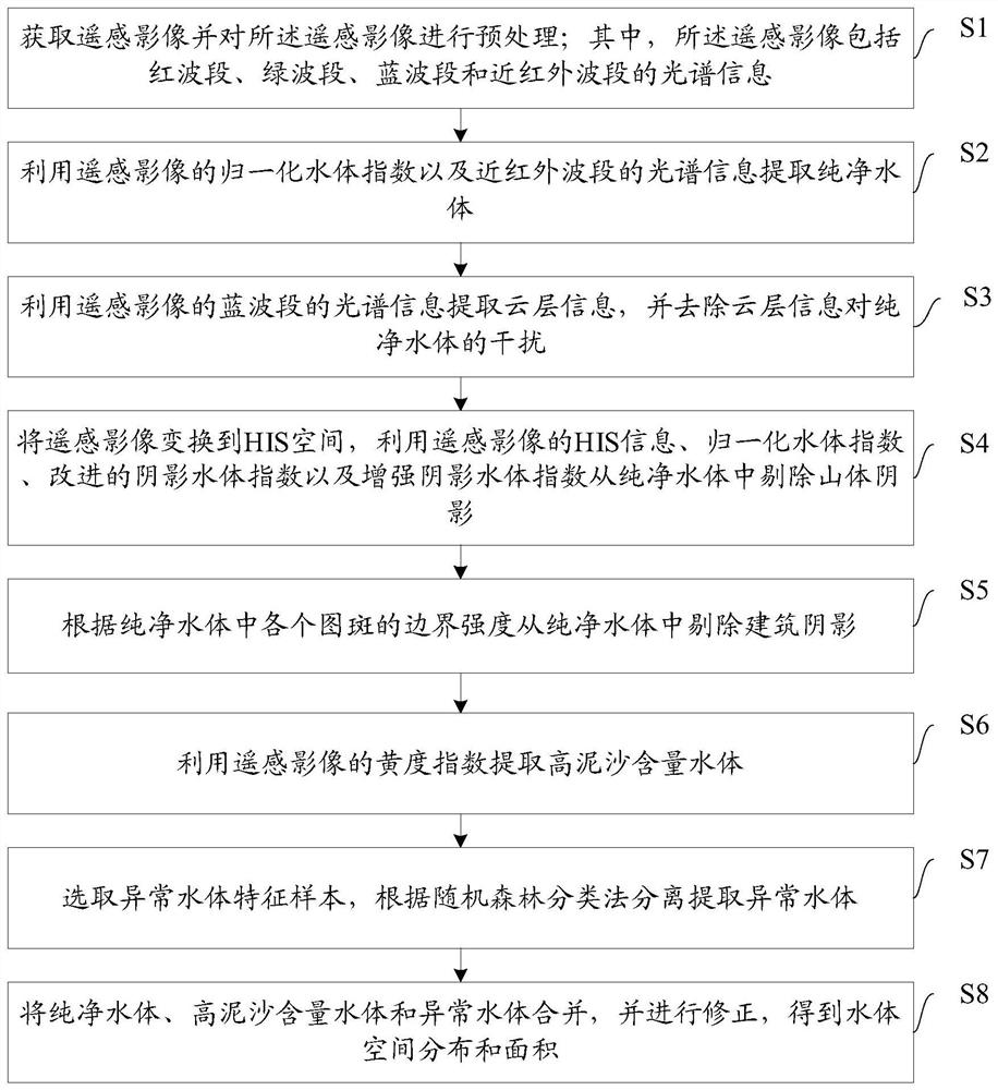
[0146] An embodiment of the present invention provides a method for automatically extracting water bodies from remote sensing images, such as figure 1 As shown, the method includes:

[0147] S1: Obtain remote sensing images and preprocess the remote sensing images; wherein, the remote sensing images include spectral information of red band, green band, blue band and near-infrared band.

[0148] This step is used to obtain the satellite remote sensing image containing the water body to be extracted and obtain the basic parameter information of the satellite remote sensing image, including spatial scale (resolution), number of bands, spectral range, projected coordinates, non-imaging area value, etc. The remote sensing image contains at least "Red (red), Green (rate), Blue (blue), Near Infrared (near infrared)" 4 spectral bands. The remote sensing image can be an original image, or a high-level image processed by radiometric calibration, atmospheric correction, geometric correc...

Embodiment 2

[0246] An embodiment of the present invention provides a remote sensing image water automatic extraction device, such as Figure 8 As shown, the device includes:

[0247] The image acquisition module 1 is used to acquire remote sensing images and preprocess the remote sensing images; wherein, the remote sensing images include spectral information of red band, green band, blue band and near infrared band.

[0248] The pure water extraction module 2 is used to extract pure water by using the normalized water index of the remote sensing image and the spectral information in the near-infrared band.

[0249] The cloud layer interference removal module 3 is used to extract cloud layer information by using the spectral information of the blue band of the remote sensing image, and remove the interference of the cloud layer information on the pure water body.

[0250] The hill shadow removal module 4 is used to transform the remote sensing image into HIS space, and remove the hill sha...


PUM


Abstract

The invention discloses a remote sensing image water body automatic extraction method and device, and belongs to the field of water body monitoring. According to the method, satellite remote sensing images and imaging parameters are obtained and preprocessed, and then, feature information such as NDWI, MSWI, ESWI, Yellow and Canny of a water body is constructed based on spectrum, gradient, statistical features and the like of the images; NDWI and p(NIR) features are utilized to identify a purified water body, then feature information is coupled, and misclassification of clouds, buildings and mountain shadows is comprehensively removed; a yellowness characteristic and a characteristic water body sample are constructed to supplement a high-sand-content water body and other abnormal water bodies; and finally, boundary processing and minimum pattern spot adjustment are carried out to obtain the spatial distribution of the pervasive water body. According to the invention, the problem of wrong division of the water body caused by shadows and clouds of buildings, mountains and the like is solved, the problem of division leakage of abnormal water bodies such as high-sediment-content water bodies and eutrophication is solved, and the limitation of water body information extraction under the background of a traditional single threshold value and complex ground features is overcome.

Description

technical field [0001] The invention relates to the field of water body monitoring, in particular to a method and device for automatically extracting water bodies from remote sensing images. Background technique [0002] Water body information is an important basic geographic information data in water conservancy planning, water resource investigation, protection and monitoring, flood disaster emergency rescue, dynamic changes in water storage, etc. Mastering the coverage of water body information is important for dynamic monitoring of water resources and ensuring water source safety , reasonable planning and protection play a huge role. [0003] Remote sensing has strong advantages in the extraction of water body information in large-scale spatial ranges, such as short-period observations, wide coverage, rich spatial resolution and scale information, and large spectral information. Quality monitoring, inspection of black and odorous water bodies in cities, monitoring of tu...

Claims


Application Information

Patent Timeline
Patent Type & Authority Applications(China)
IPC IPC(8): G06K9/00G06K9/20G06T7/11G06T7/136G06T7/168G06T7/507
CPCG06T7/11G06T7/136G06T7/168G06T7/507G06V20/13G06V10/143
Inventor 毕京鹏马万栋申文明陈绪慧郭艳玲肖桐李静张新胜史雪威毕晓玲史园莉申振张雪吴玲王丽霞任致华蔡明勇张宏伟邰文飞
Owner MINISTRY OF ECOLOGY & ENVIRONMENT CENT FOR SATELLITE APPL ON ECOLOGY ENVIRONMENT
Why Eureka
Try Eureka