Big data-based topographic section cutting parallel computing method and system

A parallel computing and cutting-plane technology, applied in database design/maintenance, computing, structured data retrieval, etc., can solve the problems of large data volume, difficult retrieval, and low repetition rate.

Inactive Publication Date: 2021-07-30
CHINA RAILWAY DESIGN GRP CO LTD
View PDF5 Cites 0 Cited by
  • Summary
  • Abstract
  • Description
  • Claims
  • Application Information

AI Technical Summary

Problems solved by technology

Compared with the traditional two-dimensional design, the application of engineering digitalization has produced massive and diverse information data on the one hand, and the existing relational database and text storage methods can no longer meet the needs for efficient storage and utilization of data; on the other hand, the traditional The data processing method has become a constraint on production efficiency in the processing of massive data
Terrain data is an important supporting data for engineering digital applications, and the amount of data is large, especially when it takes a long time to process the cut surface of terrain data. At present, there is no better solution
[0003] At present, in the field of survey and design, the calculation efficiency of topographic data section can no longer meet the requirements of engineering digital application. On the one hand, a large amount of data is stored in the computer folder in the form of files, resulting in difficult retrieval and low reuse rate; on the other hand On the one hand, the traditional stand-alone mode is used to calculate the section of a large amount of terrain data, which is inefficient and time-consuming. Therefore, it is an urgent technical problem to be solved in this field to design a parallel calculation method of terrain section based on big data.
[0004] Difficulty in solving the above-mentioned technical problems: At present, in the field of survey and design, it takes a long time to process the cut-off surface of terrain data, which cannot meet the requirements of engineering digital application. There is no good solution yet, and there are many technical difficulties. Including high-efficiency access to massive data, block model establishment of terrain data, parallel processing of section algorithm and merging of distributed processing results, etc., all of which have great research difficulties

Method used


Image

  • Big data-based topographic section cutting parallel computing method and system
  • Big data-based topographic section cutting parallel computing method and system
  • Big data-based topographic section cutting parallel computing method and system

Examples


Embodiment Construction

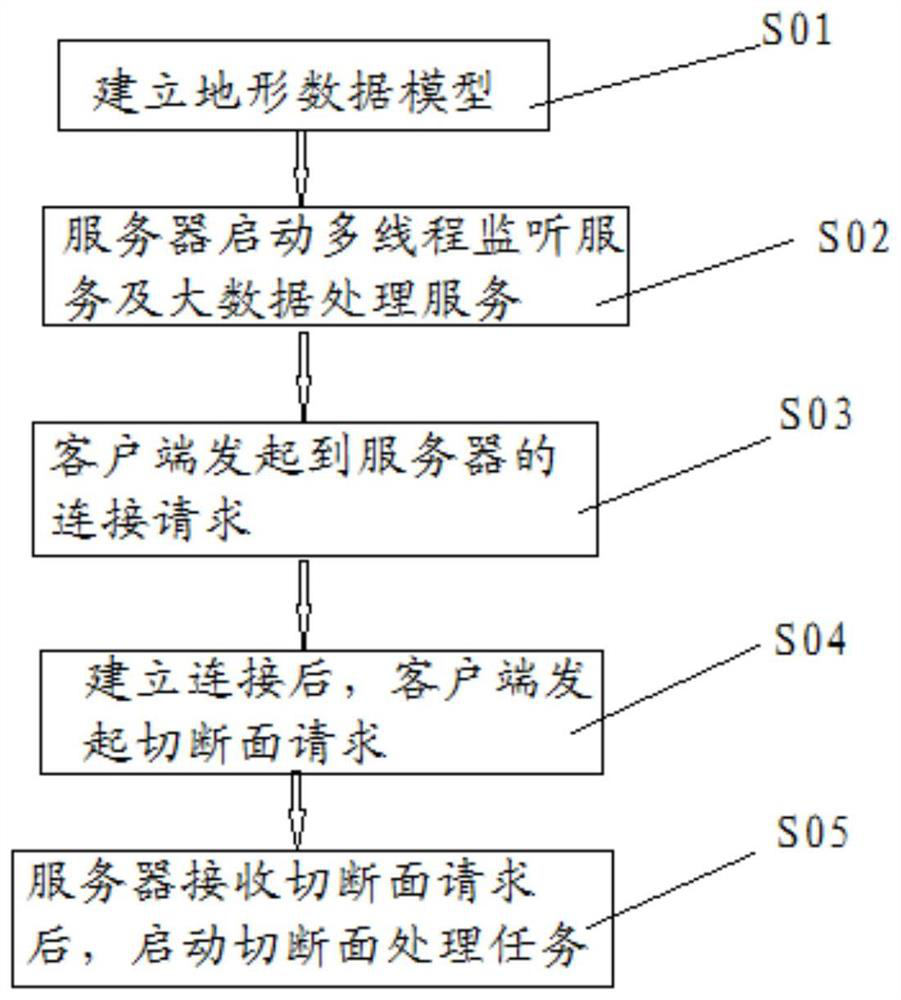
[0050] Reference will now be made in detail to the exemplary embodiments, examples of which are illustrated in the accompanying drawings. When the following description refers to the accompanying drawings, the same numerals in different drawings refer to the same or similar elements unless otherwise indicated. The implementations described in the following exemplary examples do not represent all implementations consistent with the present disclosure. Rather, they are merely examples of apparatuses and methods consistent with aspects of the present disclosure as recited in the appended claims.

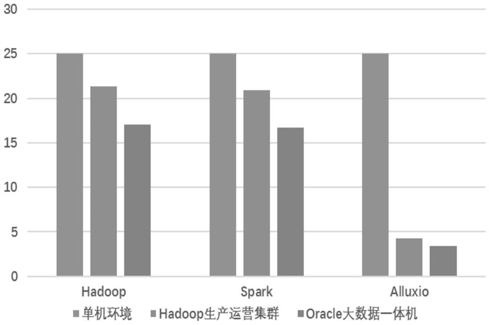
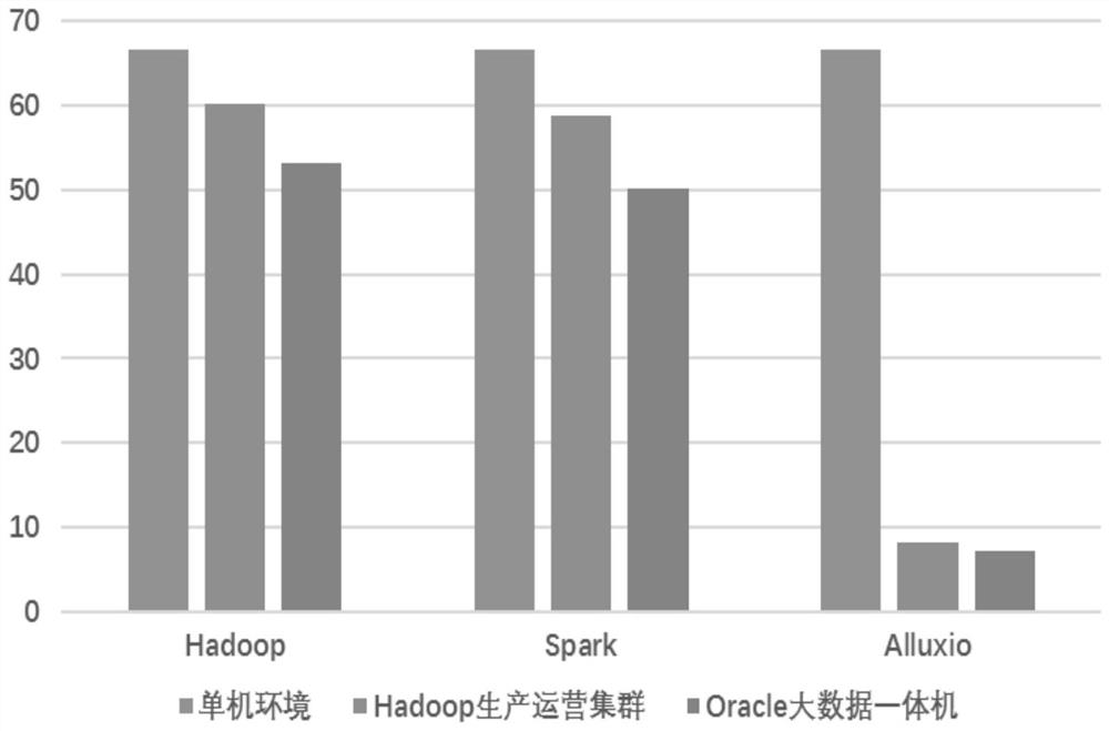
[0051]The technical solution provided by the disclosed embodiments of the present invention relates to a method and system for parallel computing of topographic section based on big data, especially to the field of survey and design. In related technologies, in the field of survey and design, the calculation efficiency of topographic data cross-sections can no longer meet the requireme...


PUM


Abstract

The invention discloses a big data-based topographic section cutting parallel computing method and system, and relates to the field of investigation design, wherein the method comprises the following steps: step 1, a topographic data model is built; step 2, a server starts a multi-thread monitoring service and a big data processing service; step 3, a client initiates a connection request to the server; step 4, after the connection is established, the client initiates a section cutting request; and step 5, after the server receives the section cutting request, a section cutting processing task is started. According to the technical scheme, the production efficiency is greatly improved, and particularly, the method is suitable for section cutting calculation of massive topographic data. According to the method, the functions of topographic data distributed storage, data fragmentation, data parallel processing and data preloading to a memory are realized by utilizing a big data processing technology, the problems of disordered storage of traditional topographic data and low section cutting calculation efficiency are solved, retrieval and reutilization of the topographic data are effectively promoted, and the section cutting calculation performance is improved.

Description

technical field [0001] The disclosure of the present invention relates to the field of survey and design, and in particular to a method and system for parallel computing of topographic section based on big data. Background technique [0002] With the development of survey and design business, the application of engineering digital technology has become more and more extensive, and GIS, BIM and 3D collaborative technology have been rapidly promoted. Compared with the traditional two-dimensional design, the application of engineering digitalization has produced massive and diverse information data on the one hand, and the existing relational database and text storage methods can no longer meet the needs for efficient storage and utilization of data; on the other hand, the traditional Data processing methods have become a constraint on production efficiency in the processing of massive data. Terrain data is an important supporting data for engineering digital applications, and...

Claims


Application Information

Patent Timeline
Patent Type & Authority Applications(China)
IPC IPC(8): G06F16/182G06F16/21G06F16/29
CPCG06F16/182G06F16/212G06F16/29
Inventor 张振京陈志军郭容昱侯继伟于煬陈昕宇
Owner CHINA RAILWAY DESIGN GRP CO LTD
Why Eureka
Try Eureka