Aerial remote sensing image splicing method assisted by pose information

A pose information, aerial remote sensing technology, applied in the field of aerial remote sensing image stitching aided by pose information, can solve the problems of easy failure of remote sensing image stitching, and achieve the effects of improving stitching performance, reducing stitching errors, and improving speed.

Pending Publication Date: 2021-08-06
BEIHANG UNIV
View PDF0 Cites 5 Cited by
  • Summary
  • Abstract
  • Description
  • Claims
  • Application Information

AI Technical Summary

Problems solved by technology

[0003] The present invention provides an aerial remote sensing image splicing method assisted by pose information to increase the speed of aerial remote sensing image splicing and solve the problem that remote sensing image splicing with single landform and few features is prone to failure

Method used


Image

  • Aerial remote sensing image splicing method assisted by pose information
  • Aerial remote sensing image splicing method assisted by pose information
  • Aerial remote sensing image splicing method assisted by pose information

Examples


Embodiment 1

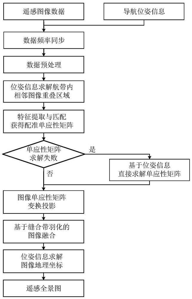
[0089] A pose information-assisted aerial remote sensing image mosaic method, the specific flow chart is as follows figure 1 As shown, the steps are as follows:

[0090] S1: Job acquisition and preprocessing of remote sensing image data and navigation pose data;

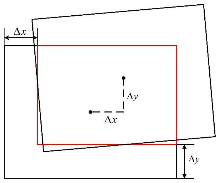
[0091] S2: Calculate the displacement of the adjacent images of the flight belt according to the pose information, and solve the overlapping area of ​​the images;

[0092] S3: Extract image features of overlapping areas, locate feature points and generate feature descriptors, perform feature matching, solve image transformation homography matrix, and realize image registration;

[0093] S4: Analyze the registration quality of the image registration results based on overlapping region features. If the registration fails, convert the navigation system pose information into the rotation matrix and translation vector of the camera, and directly solve the homography matrix between images to realize the image Registratio...

Embodiment 2

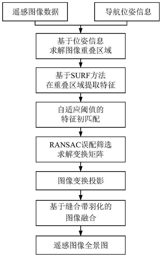
[0162] The invention provides a pose information-assisted aerial remote sensing image mosaic method, comprising the following steps:

[0163] First of all, design the shooting time and route of the operation experiment; do the calibration experiment of the camera sensor and the navigation system in advance, including calibrating the time difference between the camera and the navigation system, and obtaining the internal parameters of the camera through calibration; conduct the operation experiment to obtain remote sensing image data and navigation Calculate the pose data; enhance and distort the acquired image.

[0164] Secondly, calculate the displacement of the flight belt image according to the pose information, and then solve the overlapping area of ​​adjacent images; perform feature extraction through SURF in the overlapping area, and use adaptive threshold and RANSAC for feature matching to solve the homography matrix of image transformation ;

[0165] Thirdly, the qual...


PUM


Abstract

The invention discloses an aerial remote sensing image splicing method assisted by pose information, and relates to the field of aerial photography remote sensing and image splicing. Firstly, aerial remote sensing image data and navigation pose data are obtained and preprocessed; then, the image displacement in the air strip is solved according to the pose information, and an adjacent image overlapping region is obtained; image features are extracted in the image overlapping area for matching, and an image homography matrix is solved for image registration; the image registration quality is analyzed, if registration is judged to be invalid, a homography matrix is directly solved according to the camera pose converted from the navigation data, and image registration is carried out; and finally, fusion is carried out by adopting a suture band feathering fusion method, and panorama geographic positioning is carried out according to the pose information. The pose information of the airborne navigation system is used for assisting in aerial remote sensing image splicing, the remote sensing image splicing speed is increased, splicing of images with rare features can be achieved, the remote sensing panorama with geographic information is finally obtained, and the method has high practical value.

Description

technical field [0001] The invention relates to the fields of aerial photographic remote sensing and image splicing, in particular to an aerial remote sensing image splicing method assisted by pose information. The main application of the present invention is the mosaic of aerial remote sensing photographic images of multiple scenes, including the rapid mosaic of remote sensing images with single landform and few features. Background technique [0002] With the maturity of aerial remote sensing technology and the continuous improvement of camera sensor performance, aerial photographic remote sensing images are widely used in the fields of ecological environment monitoring, urban planning and construction, comprehensive land utilization, and geographic information system construction. Limited by the contradiction between high resolution and large viewing angle, remote sensing images must be spliced ​​before they can be used in follow-up research, and the splicing quality dire...

Claims


Application Information

Patent Timeline
Patent Type & Authority Applications(China)
IPC IPC(8): G06T3/40G06T7/33
CPCG06T3/4038G06T2207/10032G06T2207/20221G06T7/33
Inventor 吴发林纪滢琳何嘉琪周国鹏杨功流
Owner BEIHANG UNIV
Why Eureka
Try Eureka