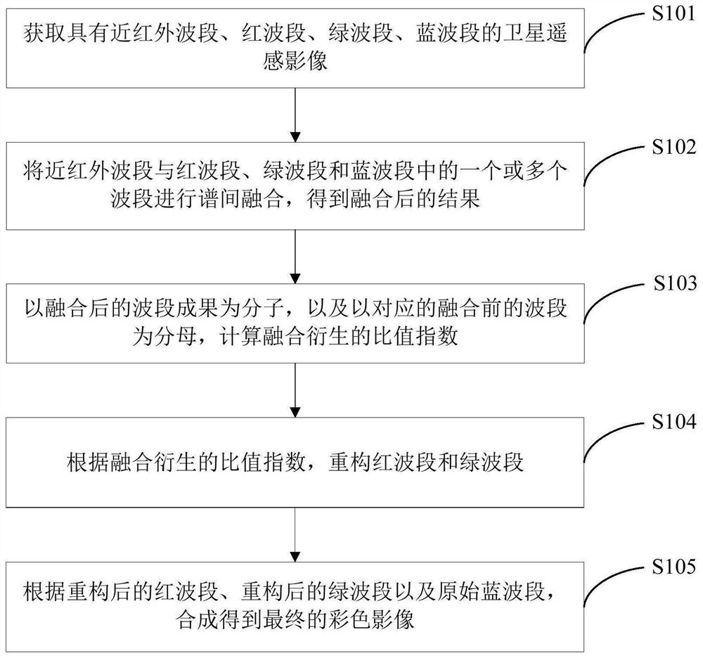
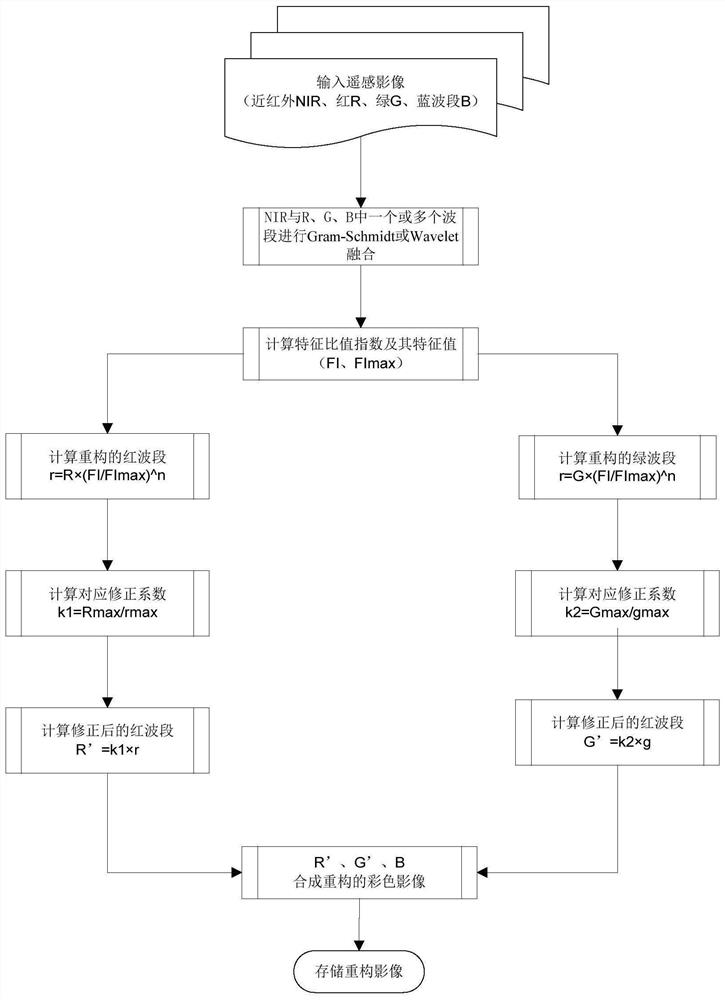
Remote sensing image fusion method, system and device based on fusion derivative index and medium
A remote sensing image and fusion method technology, which is applied in the field of satellite remote sensing image fusion, can solve the problems of weak layering, low efficiency, and spectral response distortion of image ground objects in true color combined images, so as to improve the visual resolution of true color remote sensing images. Force and computer analytical power, clear physical meaning, and the effect of expanding application space
- Summary
- Abstract
- Description
- Claims
- Application Information
AI Technical Summary
Problems solved by technology
Method used
Image
Examples
Embodiment 1
[0145] The color reconstruction effect evaluation technology includes visual evaluation and quantitative evaluation, the specific description is as follows:
[0146] 1) Visual evaluation: As we all know, although the original remote sensing true-color image has the same color as the ground features on the water body and bare land, but the color is dim and the layers are unclear in the vegetation area. Generally, true-color images need to obtain true-color images in which the above-mentioned ground features are consistent with the ground color by enhancing the vegetation. That is to say, the vegetation is based on green, and vegetation of different types and coverages presents various shades and shades of green; the water body is based on blue, except for components such as vegetation coverage on the water surface, high concentration of sand, and high pollution. In addition to different green, yellow, black, etc., the main body is various shades of blue; other exposed land such...
Embodiment 2
[0236] Steps S101 and S102 in this embodiment are the same as in Embodiment 1, except for steps S103 and S104.
[0237] Such as Figure 13 As shown, in this embodiment, step S103 specifically includes:
[0238] 1) According to the ratio index derived from fusion, its maximum value and average value are obtained statistically.
[0239] 2) Calculate the normalized index, the maximum value of the normalized index, and the normalized index value corresponding to the average value of the ratio index according to the fusion-derived ratio index and its maximum value and average value.
[0240] For a specific satellite remote sensing image, the fusion-derived ratio index FI has a corresponding statistical maximum value and a statistical minimum value, respectively denoted as: FI min ,FI max . The corresponding normalized index When constructing the power function of the normalized index according to the ratio index, it is necessary to ensure that the base of the power function...
Embodiment 3
[0291] Steps S101 and S102 in this embodiment are the same as in Embodiment 1, except for steps S103 and S104.
[0292] Such as Figure 21As shown, in this embodiment, step S103 specifically includes:
[0293] 1) According to the ratio index derived from the fusion, its maximum value is obtained statistically.
[0294] For a specific satellite remote sensing image, the fusion-derived ratio index FI has a corresponding statistical maximum value and a statistical minimum value, respectively denoted as: FI min ,FI max . Then the expression of the color reconstruction function f(FI) is as follows:
[0295]
[0296] Among them, 0≤1. Its minimum value is maximum f max =2. In the [0,+∞) interval, the first derivative is greater than or equal to 0, and the second derivative is less than or equal to 0, so no matter what value n takes on the domain, the color reconstruction function is a monotonically increasing convex curve. Such a function has the same monotonicity as the...
PUM
 Abstract
Description
Claims
Application Information
 - R&D
- Intellectual Property
- Life Sciences
- Materials
- Tech Scout
- Unparalleled Data Quality
- Higher Quality Content
- 60% Fewer Hallucinations
Browse by: Latest US Patents, China's latest patents, Technical Efficacy Thesaurus, Application Domain, Technology Topic, Popular Technical Reports.
© 2025 PatSnap. All rights reserved.Legal|Privacy policy|Modern Slavery Act Transparency Statement|Sitemap|About US| Contact US: help@patsnap.com


