Method for producing digital elevation model by using three-line array three-dimensional satellite image

A digital elevation model, stereo image technology, applied in height/level measurement, photogrammetry/video measurement, measurement devices, etc., can solve problems such as great influence of matching effect, low DEM quality, and difficulty in detecting occlusions. , to achieve strong applicability and scalability, improve the matching success rate, and the method is simple and reliable.

Active Publication Date: 2021-09-07
自然资源部国土卫星遥感应用中心
View PDF5 Cites 4 Cited by
  • Summary
  • Abstract
  • Description
  • Claims
  • Application Information

AI Technical Summary

Problems solved by technology

However, the algorithm of this method has high complexity and low maturity, and it is not easy to detect suspicious areas such as occlusion. When there are large differences in phase, radiation and geometry between different images that constitute a stereoscopic image, it will have a great impact on the matching effect. The quality of the DEM generated by the match is not high
In short, the current methods of generating DEM using three-view (or multi-view) stereo images with multiple overlapping coverages have relatively large limitations, and it is urgent to find other new technical methods in order to make full use of three-view (or multi-view) stereo images. information advantages, more effectively realize the production of high-quality DEM products

Method used


Image

  • Method for producing digital elevation model by using three-line array three-dimensional satellite image
  • Method for producing digital elevation model by using three-line array three-dimensional satellite image
  • Method for producing digital elevation model by using three-line array three-dimensional satellite image

Examples


Embodiment Construction

[0019] In order to make the object, technical solution and advantages of the present invention clearer, the present invention will be further described in detail below in conjunction with the embodiments and accompanying drawings.

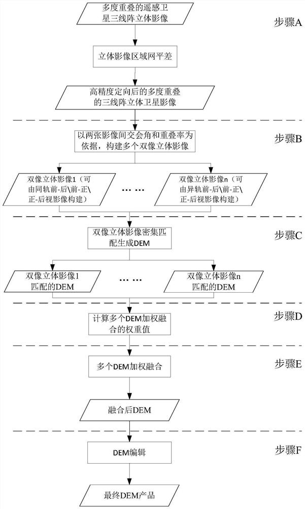
[0020] Such as figure 1 As shown, the method for producing a digital elevation model using three-line array stereo satellite images includes the following steps:

[0021] Step 1) Construct the adjustment area network of three-line array stereoscopic images of remote sensing satellites with multiple overlaps in the production task area, measure the dense connection points and measure the appropriate amount of image control points as needed, select the appropriate block adjustment model, Iterative adjustment calculations are performed uniformly in the region until the adjustment accuracy requirements are met, all image imaging geometric model error compensation parameters are obtained, and a new image imaging geometric model is output to complete the...


PUM


Abstract

The invention discloses a method for producing a digital elevation model by using three-line array three-dimensional satellite images, which comprises the following steps of: constructing an adjustment block for multi-degree overlapped and covered remote sensing satellite three-line array three-dimensional images in a production area, finishing block adjustment, and realizing high-precision orientation of all the images; then, according to index values such as an overlapping ratio and a same-name light intersection angle between any two images, constructing a plurality of pairs of double-image stereoscopic images from the multi-degree overlapped and covered three-line-array stereoscopic images, and respectively extracting a digital elevation model (DEM) by adopting an image dense matching algorithm; and finally, calculating a weight value of each double-image stereoscopic image according to indexes such as an intersection angle and relative precision of the double-image stereoscopic images, time phase difference forming the images and the like, and carrying out weighted fusion on DEMs extracted from all the double-image stereoscopic images in the region based on the weight values to generate a final DEM product. According to the method, the information advantage of the three-linear-array stereo image is fully utilized, and the matching success rate, the resolution ratio and the product quality of the DEM can be effectively improved.

Description

technical field [0001] The invention relates to the technical field of digital elevation model production in surveying and mapping geographic information products, in particular to a digital elevation model production method based on multi-degree overlapping coverage of three-dimensional satellite images of remote sensing satellites. Background technique [0002] Surveying and mapping geographic information resource is a national basic and strategic information resource, which plays an increasingly important role in government management decision-making, industrial development, and people's life. Digital elevation model (Digital Elevation Model, DEM) is a digital simulation of ground terrain through limited terrain elevation data. It is a solid ground model that expresses ground elevation in the form of a set of ordered numerical arrays. As an important form of surveying and mapping geographic information results, DEM is widely used in surveying and mapping, hydrology, meteo...

Claims


Application Information

Patent Timeline
Patent Type & Authority Applications(China)
IPC IPC(8): G01C5/00G01C11/00G01C15/00
CPCG01C5/00G01C15/00G01C11/00
Inventor 周平郭莉张振华薛白陈颖刘昌儒岳明宇王艺颖
Owner 自然资源部国土卫星遥感应用中心
Why Eureka
Try Eureka