Bridge pier foundation scour area terrain three-dimensional reconstruction method based on scanning sonar imaging

A scanning sonar and three-dimensional reconstruction technology, which is applied in the direction of sound wave re-radiation, measuring instruments, instruments, etc., can solve problems such as low detection efficiency, discrete measured data, and device failure

Active Publication Date: 2021-09-10
FUZHOU UNIV
View PDF9 Cites 0 Cited by
  • Summary
  • Abstract
  • Description
  • Claims
  • Application Information

AI Technical Summary

Problems solved by technology

[0003] The traditional foundation scour detection device has high installation and maintenance costs, and it is easily affected by debris during floods, causing the device to fail, and the measured data is relatively discrete, and the detection efficiency is low
Compared with traditional detection devices, sonar equipment is easier to install. A single scan of the foundation scour can obtain multiple scour depth data. The detection efficiency is high, and the found...

Method used


Image

  • Bridge pier foundation scour area terrain three-dimensional reconstruction method based on scanning sonar imaging
  • Bridge pier foundation scour area terrain three-dimensional reconstruction method based on scanning sonar imaging
  • Bridge pier foundation scour area terrain three-dimensional reconstruction method based on scanning sonar imaging

Examples


Embodiment Construction

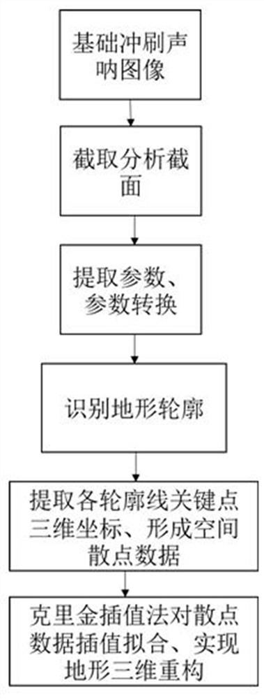
[0030] As shown in the figure, the three-dimensional reconstruction method of the topography of the scoured area of ​​the pier foundation based on scanning sonar imaging, the method includes the following steps;

[0031] Step S1, using mechanical scanning sonar equipment to scan and image the topography of the scoured area of ​​the pier foundation from different azimuths, and collect n groups of foundation scoured terrain acoustic images in different azimuths;

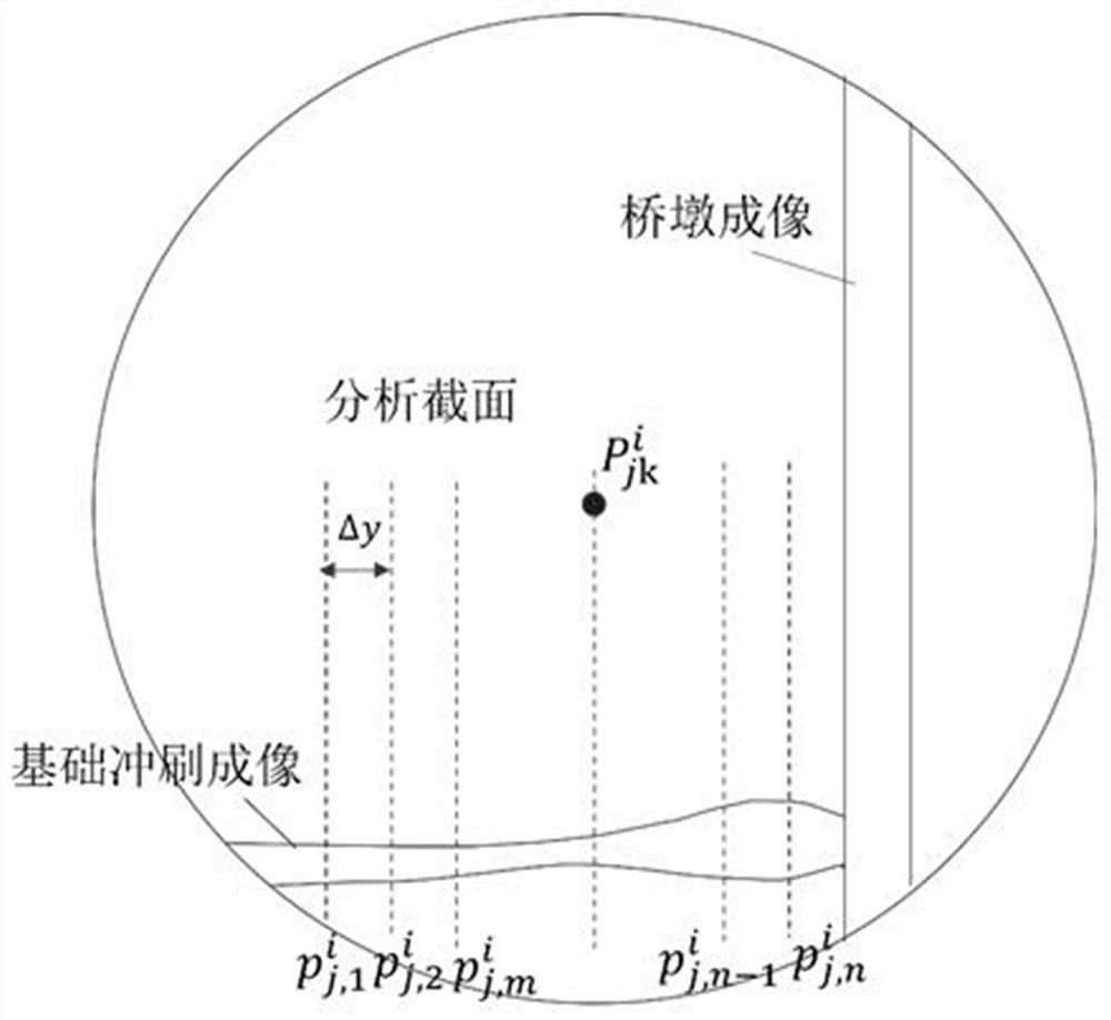
[0032] Step S2, intercepting multiple analysis sections at the same interval for each group of collected acoustic images;

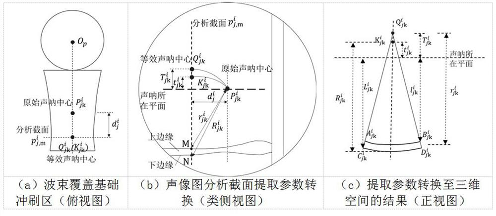
[0033] Step S3, extracting the key parameters of the upper and lower edges of the terrain imaging strip in the analysis section in the figure, converting the extracted parameters into three-dimensional space according to the principle of acoustic imaging, and expressing the sonar beam fan plane with a fan arc;

[0034] Step S4, according to the relative positional relationship of a group of measur...


PUM


Abstract

The invention provides a bridge pier foundation scour area terrain three-dimensional reconstruction method based on scanning sonar imaging. The method comprises the steps: S1, using sonar to carry out complete scanning imaging on the topography of a pier foundation scour area from different directions, and collecting n groups of foundation scour topography acoustic images; s2, intercepting a plurality of analysis sections from the collected acoustic image at the same interval; s3, extracting key parameters of the upper edge and the lower edge of a geographic imaging strip in an analysis section in the image, and converting the key parameters into a three-dimensional space, and expressing a sonar beam sector by a sector arc; s4, according to the sector arc relative position relation of a group of measuring points in the same analysis section, identifying the scouring terrain contour form; s5, identifying each terrain contour form one by one, and respectively extracting spatial scatter three-dimensional coordinate data; and s6, performing interpolation fitting on the spatial scatter data by adopting a Kriging interpolation method to complete three-dimensional reconstruction of the basic scoured terrain. According to the invention, the purpose of three-dimensional restoration of the topography of the pier foundation scouring area can be realized.

Description

technical field [0001] The invention relates to the technical field of detection of underwater pier foundation scour topography, in particular to a method for three-dimensional reconstruction of the topography of pier foundation scour areas based on scanning sonar imaging. Background technique [0002] The pier foundation has been in a complex water environment for a long time. Under the action of scour, the river bed is continuously cut down, the buried depth of the foundation is reduced, and the scour disease of the foundation is formed. When encountering floods, the scouring effect is more intense. Under the long-term local scouring action, old bridges have major safety hazards, and they are prone to overturning under severe flood erosion. Therefore, regular detection of pier foundation scour and mastering the scour condition of bridge pier foundation can provide information and support for the structural state safety assessment of bridge engineering and the prevention an...

Claims


Application Information

Patent Timeline
IPC IPC(8): G01S15/89G01S7/539G01C15/00
CPCG01S15/89G01S7/539G01C15/00G01S7/6245G01S7/53G06T17/05G01S7/403G01S15/8993G06T17/20G06T2207/10028G06T2215/16
Inventor 沈圣陈建腾姜绍飞曹峥李明贤
Owner FUZHOU UNIV
Why Eureka
Try Eureka