
A UAV Navigation Method Based on Semantic vslam

A navigation method and unmanned aerial vehicle technology, applied in navigation, surveying and mapping and navigation, navigation computing tools, etc., can solve the problems of high cost of lidar, complex indoor environment, complex placement of low-light objects, etc., to improve accuracy and pan- The effect of optimizing ability, increasing planning speed, and reducing loss of accuracy

Active Publication Date: 2022-03-22
HANGZHOU DIANZI UNIV
View PDF7 Cites 0 Cited by
  • Summary
  • Abstract
  • Description
  • Claims
  • Application Information

AI Technical Summary

Problems solved by technology

The traditional positioning method can only provide a relative coordinate position for positioning and navigation, while most of the maps generated by lidar SLAM are 2D grid maps, which can only be applied to positioning and navigation on one plane, but the cost of multi-dimensional lidar is very high. Expensive, complex indoor environment, low light and complex placement of objects

Method used


Image

  • A UAV Navigation Method Based on Semantic vslam
  • A UAV Navigation Method Based on Semantic vslam
  • A UAV Navigation Method Based on Semantic vslam

Examples


Embodiment Construction

[0032] The present invention will be further described below in conjunction with the accompanying drawings and specific embodiments.

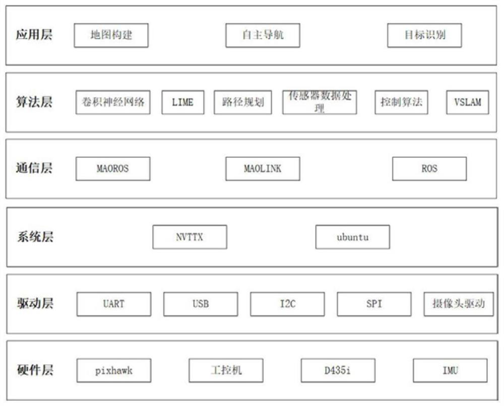
[0033] like figure 1 As shown, the present invention is divided into application layer, algorithm layer, communication layer, software driver layer and hardware layer five parts, and application layer is the existing function realized by the present invention, considers expansibility during design, leaves software extension interface , and other functions can be developed on the present invention. The main functions include visual map construction, autonomous navigation and target recognition, fixed-point altitude determination, track flight, etc.; the algorithm layer is the core layer of the present invention, which is divided into upper-level perception algorithm layer and lower-level control Algorithmic layer. The upper layer mainly includes target detection convolutional neural network Yolov4-tiny, path planning algorithm FAST-planner, A*,...


PUM


Abstract

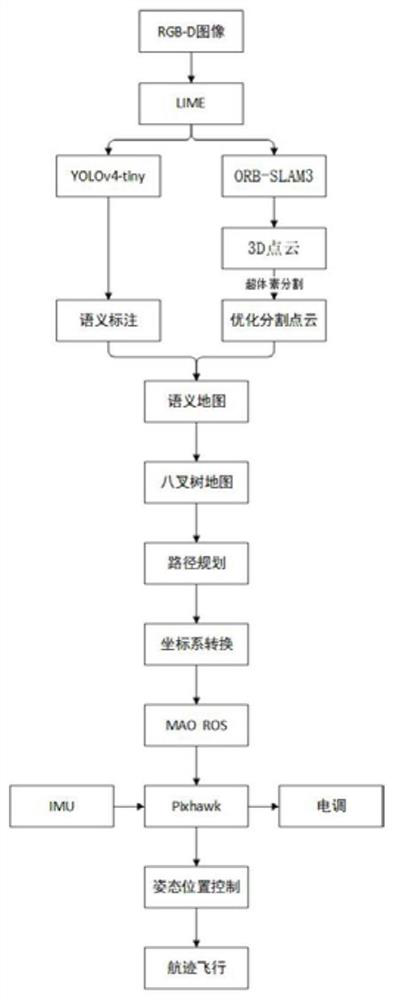
The invention discloses an unmanned aerial vehicle navigation method based on semantic VSLAM. The invention combines the LIME photometric enhancement algorithm to preprocess the input image, so that the SLAM system is more robust in the low-light environment. On the basis of the lightweight neural network Yolov4-Tiny, it is optimized by combining data enhancement, transfer learning, initial learning rate setting and cosine learning rate adjustment strategy to further improve the accuracy and generalization ability of the network model. Combining with super-voxel pre-segmentation of 3D dense point cloud, and then mapping the 2D object annotation to the segmented point cloud, it is more efficient to realize 3D annotation to form a semantic map. Combining local planning algorithm, global planning algorithm and Fast-planner algorithm for trajectory optimization to adapt to complex environments and increase planning speed.

Description

technical field [0001] The invention belongs to the technical field of computer indoor positioning, and in particular relates to a navigation method for unmanned aerial vehicles based on semantic VSLAM. Background technique [0002] As a type of robot, drones are widely used in crop detection, transportation, logistics distribution, exploration of natural resources, smart city applications and other fields. [0003] Most of the outdoor automatic positioning systems of drones now use Global Positioning System (GPS), or even ultra-high-precision Real-time kinematic (RTK), so drones can achieve better positioning and navigation effects outdoors. But indoors or where there is no GPS, you need to rely on other methods for positioning and navigation. Traditional indoor positioning solutions include ultra-wideband technology, Bluetooth, two-dimensional codes, radio frequency identification, optical capture systems, etc., as well as the more advanced laser radar real-time positioni...

Claims


Application Information

Patent Timeline
Patent Type & Authority Patents(China)
IPC IPC(8): G01C21/16G01C21/20G06T17/00G06T17/05G06T17/20G06N3/04G06N3/08
CPCG01C21/16G01C21/206G06T17/005G06T17/05G06T17/20G06N3/08G06N3/045
Inventor 岳晨曦孙浩孙玲玲李郑慧胡莉英
Owner HANGZHOU DIANZI UNIV
Learn More