A real-time mapping system and mapping method based on v2x

A map and coordinate system technology, applied in the field of real-time mapping system based on V2X, can solve the maintenance burden of the Internet of Vehicles center, affect the communication between the vehicle terminal and the Internet of Vehicles center, etc., to ensure safe operation, improve driving safety, reduce The effect of incidence

Active Publication Date: 2022-05-31
CHANGCHUN YIHANG INTELLIGENT TECH CO LTD
View PDF3 Cites 0 Cited by
  • Summary
  • Abstract
  • Description
  • Claims
  • Application Information

AI Technical Summary

Problems solved by technology

However, this solution is only applicable to the situation where the vehicle terminals all belong to the same vehicle networking center
The vehicle-mounted terminals all belong to the same IoV center. This situation is only suitable for local areas. If only one IOV center is used for a large-scale IOV center, it will affect the communication between the vehicle-mounted terminal and the IOV center, and it will affect the maintenance of the IOV center. cause a burden

Method used


Image

  • A real-time mapping system and mapping method based on v2x
  • A real-time mapping system and mapping method based on v2x
  • A real-time mapping system and mapping method based on v2x

Examples


Embodiment 1

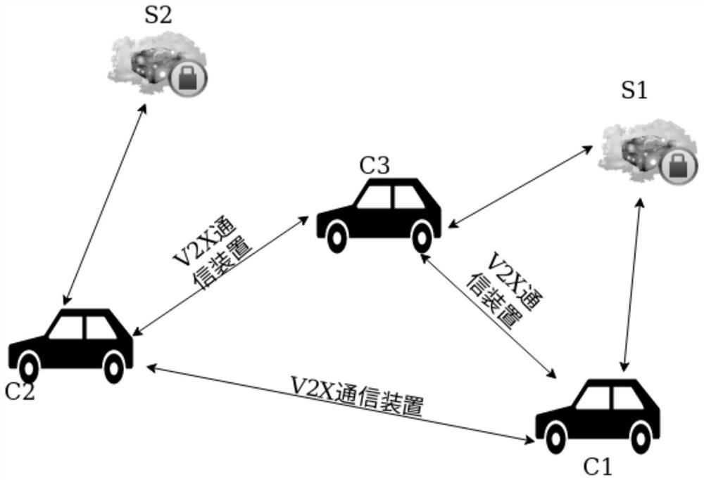
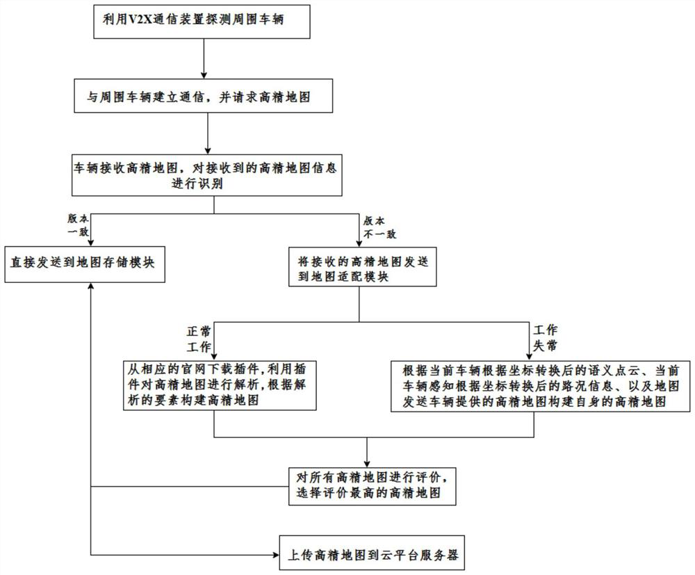
[0086] If the current vehicle does not establish communication with the surrounding vehicles, the surrounding environment is monitored according to the sensors installed in the current vehicle.

Embodiment 2

[0104] 1.2) If no information sent by other vehicles is received, the surrounding environment will be monitored according to the sensors installed in the vehicle C1.

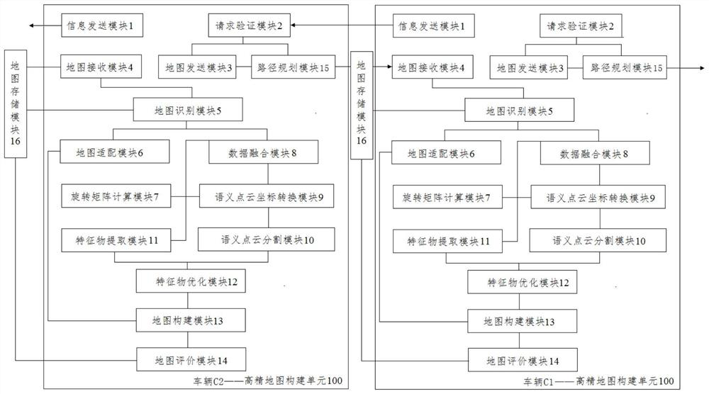
[0117] According to the high-precision map version information sent by the vehicle C2, extract the feature of the object level in the positioning layer; extract

[0119] The fusion of point cloud data and image data can enrich the information of the point cloud, which is beneficial to the subsequent processing and extraction of the point cloud data.

[0120] The lidar space rectangular coordinate system is based on the lidar center of gravity as the origin, the Y axis points to the direction of the car, and the Z axis

[0123] 4.5) For 4.1) Object-level features in locating layers and 4.4) Segmentation semantics after coordinate transformation

[0124] 4.6) According to the transformation matrix calculated in 4.5), coordinate transformation is performed on the semantic point cloud obtained in 4.4) to improve the

[0...


PUM


Abstract

A V2X-based real-time mapping system and mapping method, the system includes a vehicle, a V2X communication device, and a cloud platform server; sensors are installed on the vehicle to sense the surrounding environment of the vehicle; the vehicles communicate with each other through the V2X communication device, and the vehicle A high-precision map construction unit and a map storage module are installed; the high-precision map construction unit is used to construct a high-precision map based on the data perceived by the sensor and the map information of the surrounding vehicles, including an information sending module, a request verification module, a map sending module, a map Receiving module, map recognition module, map adaptation module, rotation matrix calculation module, data fusion module, semantic point cloud coordinate conversion module, semantic point cloud segmentation module, feature extraction module, feature optimization module, map construction module, map evaluation module. The system improves the accuracy of its own vehicle positioning by processing the obtained high-precision maps of other nearby vehicles, and makes the constructed high-precision map more accurate.

Description

A real-time mapping system and mapping method based on V2X technical field The invention belongs to the technical field of automatic driving, be specifically related to a kind of real-time mapping system and mapping method based on V2X Law. Background technique High-precision electronic map, referred to as high-precision map, also known as high-resolution map (HDMap, HighDefinitionMap), is a map dedicated to driverless services. Different from traditional navigation maps, high-precision Maps can provide lane-level navigation information, featuring high precision, high dynamics, and multi-dimensionality. HD maps are reality The cornerstone of unmanned driving. [0003] At present, autonomous vehicles mainly rely on the sensors installed on the vehicle for localization and path planning. The sensor may be blocked, resulting in a blind spot of the field of view, and the sensor may have unstable performance or be caused by environmental influences. The phenomenon o...

Claims


Application Information

Patent Timeline
Patent Type & Authority Patents(China)
IPC IPC(8): G01S13/931G01S13/89G01S13/86G01S17/931G01S17/89G01S17/86G01S19/46G01S19/47H04W4/40
CPCG01S13/931G01S13/89G01S13/865G01S17/931G01S17/89G01S17/86G01S19/46G01S19/47H04W4/40
Inventor 刘立金凌鸽
Owner CHANGCHUN YIHANG INTELLIGENT TECH CO LTD
Why Eureka
Try Eureka