GNSS-based satellite celestial navigation system error autonomous calibration method and system

A technology of celestial navigation and system error, which is applied in the field of satellite autonomous navigation research, can solve the problems of large system error of celestial navigation system and the reliability of GNSS on-orbit intermittent navigation, etc., so as to improve the ability of autonomous operation, improve autonomy, and the method is correct and reliable Effect

Active Publication Date: 2021-09-28
BEIJING INST OF CONTROL ENG
View PDF13 Cites 3 Cited by
  • Summary
  • Abstract
  • Description
  • Claims
  • Application Information

AI Technical Summary

Problems solved by technology

[0004] The technical problem solved by the present invention is: Aiming at the problems of large system error of celestial navigation system, GNSS on-orbit discontinuity and low navigation reliability, a GNSS-based satellite celestial navigation system error self-calibration method is proposed, making full use of GNSS real-time The orbit determination data calibrates the system error of the celestial navigation system, so that the celestial navigation system can obtain higher navigation accuracy, ensure that the two sets of navigation systems can be used at the same time, and the availability conditions and real-time accuracy of GNSS are not high, further improving the autonomy Overall accuracy and reliability of the navigation system

Method used


Image

  • GNSS-based satellite celestial navigation system error autonomous calibration method and system
  • GNSS-based satellite celestial navigation system error autonomous calibration method and system
  • GNSS-based satellite celestial navigation system error autonomous calibration method and system

Examples


Embodiment 1

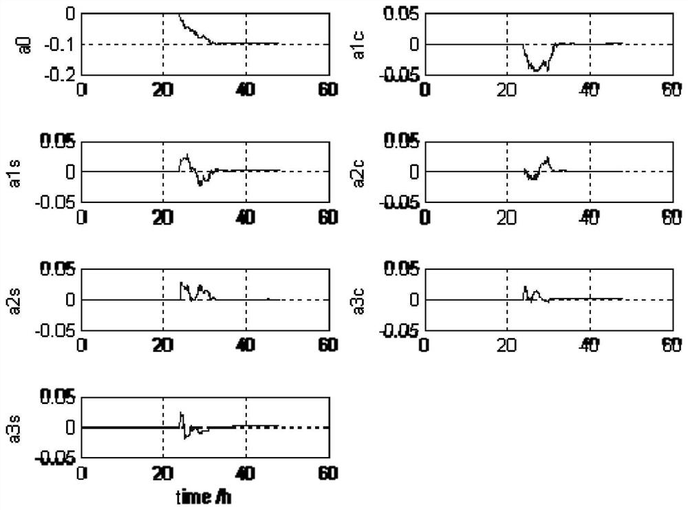
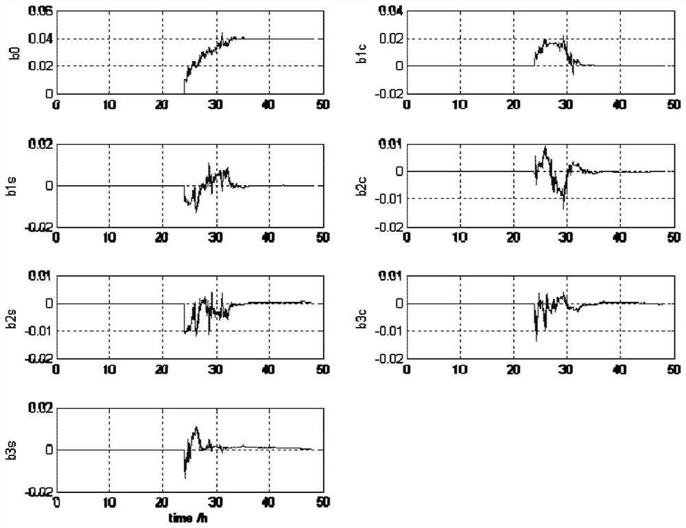
[0084] Consider that the earth sensor has a constant systematic error, such as Δθ es =-0.04°, and also has a random error of 0.02° (3σ), and at the same time, without considering the measurement error of the star sensor and GNSS, the estimated result is as follows figure 2 and image 3 As shown, the error self-calibration starts from the 24th hour, and the calibration convergence time is about 8 hours. The variables starting with a and b in the figure are respectively related to the error parameter vector in the calibration method One-to-one correspondence with the internal variables of pθ, the results show that the errors a0 and b0 of the constant value items converge to -0.1° and 0.04° respectively, which is opposite to the polarity of the set value, which is consistent with the information calculation θ ge -θ es Correlation; other parameters converge to 0.

Embodiment 2

[0086] Considering that the star sensor has a constant system error, the attitude error of the star body coordinate system relative to the inertial system is projected onto the Z axis of the body coordinate system, which is also reflected in the roll and pitch errors, and the third-order Fu The Liye basis function is used as the expression form, and the corresponding error parameters are as follows:

[0087] Px=[0.1° 0.05° 0.04° 0.03° 0.02° 0.01° 0.01°];

[0088] Py=[-0.04° -0.05° -0.04° -0.03° -0.02° -0.01° -0.01°];

[0089] At the same time, without considering the measurement errors of the earth sensor and GNSS, the estimated results are as follows Figure 4 and Figure 5 As shown, the error self-calibration starts from the 24th hour, and all the calibration results are consistent with the setting results.

[0090] Under the conditions of Example 2, two results of the celestial navigation method without error parameter compensation and with error parameter compensation w...


PUM


Abstract

According to the GNSS-based satellite celestial navigation system error autonomous calibration method and system provided by the invention, on the basis of earth center direction measurement meeting the requirement of an autonomous celestial navigation system, GNSS orbit determination data can be directly adopted, and high-precision orbit determination data can be utilized to calibrate system errors caused by installation, thermal alternation and the like in a celestial navigation measurement system in real time. The calibration method provided by the invention can be operated autonomously, the advantages and characteristics of different types of autonomous navigation systems are utilized, the precision of independent operation of the celestial navigation method is ensured through error calibration, the reliability and adaptability of the navigation system are improved, and the calibration method is also simple and feasible, and has relatively high engineering guidance significance and practical value.

Description

technical field [0001] The invention relates to a GNSS-based satellite astronomical navigation system error autonomous calibration method and system, which belongs to the research field of satellite autonomous navigation and can be applied to satellite autonomous navigation tasks. Background technique [0002] The accuracy of astronomical autonomous navigation based on the measurement of the direction of the center of the earth is mainly restricted by the measurement error of the center of the earth vector. The measurement error of the center vector mainly includes installation deviation, measurement error caused by asynchronous observation time, error caused by optical system deformation, sensor The relative reference error caused by the combination, and the measurement deviation caused by the non-spherical shape of the earth, etc. These errors are often time-varying. Based on the current experience in orbit, there are both constant value items and items closely related to t...

Claims


Application Information

Patent Timeline
Patent Type & Authority Applications(China)
IPC IPC(8): G01C25/00G01C21/24G01C21/02
CPCG01C25/00G01C21/24G01C21/02
Inventor 郭建新林波范炜常建松张春青刘新彦
Owner BEIJING INST OF CONTROL ENG
Why Eureka
Try Eureka