Evaluation method, device and storage medium for state of land system

A system state and land technology, applied in the field of data processing, can solve problems such as poor data updateability, poor estimation accuracy, inability to evaluate the state of soil organic carbon content and land system state

Active Publication Date: 2021-12-07
CHINA AGRI UNIV
View PDF6 Cites 0 Cited by
  • Summary
  • Abstract
  • Description
  • Claims
  • Application Information

AI Technical Summary

Problems solved by technology

[0004] Embodiments of the present disclosure provide a method, device, and storage medium for assessing the status of a land system, so as to at least solve the existing method for estimating soil organic carbon content in the prior art due to poor data updateability resulting in poor estimation result accuracy and the technical problem of not being able to assess the state of organic carbon in soils and the state of land systems

Method used


Image

  • Evaluation method, device and storage medium for state of land system
  • Evaluation method, device and storage medium for state of land system
  • Evaluation method, device and storage medium for state of land system

Examples


Embodiment 1

[0027] According to this embodiment, an embodiment of a method for assessing the state of a land system is provided. It should be noted that the steps shown in the flowcharts of the accompanying drawings can be executed in a computer system such as a set of computer-executable instructions, and, Although a logical order is shown in the flowcharts, in some cases the steps shown or described may be performed in an order different from that shown or described herein.

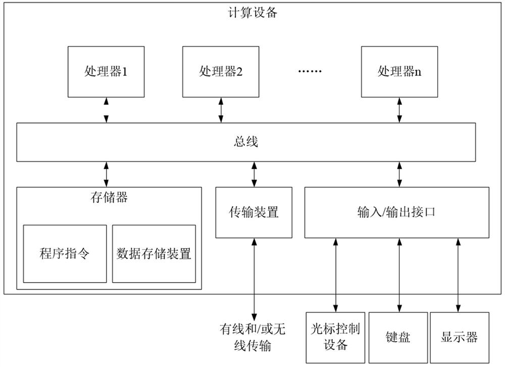
[0028] The method embodiments provided in this embodiment can be executed in mobile terminals, computer terminals, servers or similar computing devices. figure 1 A block diagram of a hardware structure of a computing device for implementing a method for assessing the state of a land system is shown. Such as figure 1 As shown, the computing device may include one or more processors (processors may include but not limited to processing devices such as microprocessors MCUs or programmable logic devices FPGAs), memory...

Embodiment 2

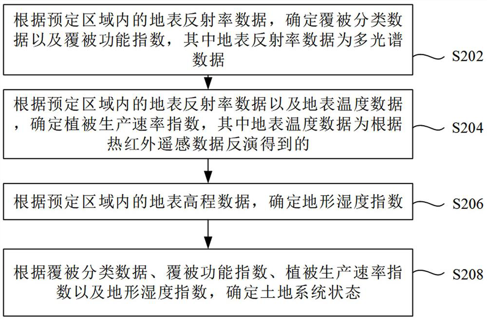
[0149] Figure 7 The apparatus 700 for assessing the state of the land system according to this embodiment is shown, and the apparatus 700 corresponds to the method described in the first aspect of Embodiment 1. refer to Figure 7 As shown, the device 700 includes: a first determination module 710, configured to determine the coverage classification data and the coverage function index according to the surface reflectance data in a predetermined area, wherein the surface reflectance data is multi-spectral data; the second determination module 710 The module 720 is used to determine the vegetation production rate index according to the surface albedo data and the surface temperature data in the predetermined area, wherein the surface temperature data is obtained from the inversion of the thermal infrared remote sensing data; the third determination module 730 is used to determine the index according to the predetermined The land surface elevation data in the area is used to de...

Embodiment 3

[0160] Figure 8 The apparatus 800 for assessing the state of the land system according to this embodiment is shown, and the apparatus 800 corresponds to the method described in the first aspect of Embodiment 1. refer to Figure 8 As shown, the device 800 includes: a processor 810; and a memory 820, connected to the processor 810, used to provide the processor 810 with instructions for processing the following processing steps: according to the surface albedo data in a predetermined area, determine the cover classification Data and cover function index, wherein the surface reflectance data is multi-spectral data; according to the surface reflectance data and surface temperature data in a predetermined area, the vegetation production rate index is determined, and the surface temperature data is obtained by inversion based on thermal infrared remote sensing data determining the topographic moisture index according to the surface elevation data in the predetermined area; and det...


PUM


Abstract

The application discloses a land system status evaluation method, device and storage medium. Among them, the evaluation method of land system status is used to evaluate the status of land system in a predetermined area, including: according to the surface albedo data in the predetermined area, determine the cover classification data and the cover function index, wherein the surface albedo data is Multi-spectral data; determine the vegetation production rate index according to the surface reflectance data and surface temperature data in the predetermined area, where the surface temperature data is obtained from the inversion of thermal infrared remote sensing data; determine the terrain according to the surface elevation data in the predetermined area Moisture Index; and Determining Land System Status from Cover Classification Data, Cover Function Index, Vegetation Production Rate Index, and Topographic Moisture Index.

Description

technical field [0001] The present application relates to the technical field of data processing, in particular to a method, device and storage medium for assessing the state of a land system. Background technique [0002] Existing soil organic carbon estimation models and methods mostly select characteristic variables from the perspective of data mining and mathematical statistics. The interpretability of the results and the comparison of model results between different regions are poor, which is not conducive to the implementation of soil organic carbon management measures. practice. Second, the reliance on historical achievement data hinders the universality of the method, and the difficulty of updating historical achievement data also reduces the accuracy of estimation results. [0003] In view of the technical problems of the existing methods for estimating soil organic carbon content in the above-mentioned prior art due to poor data renewability, poor accuracy of esti...

Claims


Application Information

Patent Timeline
Patent Type & Authority Patents(China)
IPC IPC(8): G06Q10/06G01D21/02
CPCG06Q10/0639G06Q10/06393G01D21/02
Inventor 孙丹峰焦心孙强强孙敏轩
Owner CHINA AGRI UNIV
Why Eureka
Try Eureka