
River flow velocity and water level inversion method of land-based GNSS reflectometer

A reflectometer, river technology, applied in engine lubrication, liquid/fluid solid measurement, satellite radio beacon positioning system, etc., can solve the problems of poor real-time performance, high cost and power consumption, low time sampling rate, etc. Low, rich in signal sources, providing the effect of inversion accuracy

Pending Publication Date: 2021-11-19
BEIHANG UNIV
View PDF0 Cites 0 Cited by
  • Summary
  • Abstract
  • Description
  • Claims
  • Application Information

AI Technical Summary

Problems solved by technology

Although the above-mentioned non-contact monitoring methods supplement the observation of hydrological information of rivers in larger scales and underdeveloped areas to a certain extent, they have the following deficiencies: 1) They are all targeted monitoring of single parameters such as river boundaries, water levels, and flow rates ( For example, VHF ground wave radar is only used for flow rate monitoring); 2) All parameters such as river boundary, water level, flow rate and measured river flow are used to establish empirical relationship to realize river monitoring; 3) Space-borne altimeter, SAR, multi-spectral and other remote sensing means Due to the influence of resolution and atmosphere, it is restricted in narrow river areas, rainfall and other harsh conditions, and has low time sampling rate, poor real-time performance, high cost and power consumption

Method used


Image

  • River flow velocity and water level inversion method of land-based GNSS reflectometer
  • River flow velocity and water level inversion method of land-based GNSS reflectometer
  • River flow velocity and water level inversion method of land-based GNSS reflectometer

Examples


Embodiment Construction

[0051] The following will clearly and completely describe the technical solutions in the embodiments of the present invention with reference to the accompanying drawings in the embodiments of the present invention. Obviously, the described embodiments are only some, not all, embodiments of the present invention. Based on the embodiments of the present invention, all other embodiments obtained by persons of ordinary skill in the art without making creative efforts belong to the protection scope of the present invention.

[0052] The purpose of the present invention is to provide a river flow velocity and water level inversion method of a land-based GNSS reflectometer, so as to realize low-cost and high-precision detection of river flow velocity and water level.

[0053] In order to make the above objects, features and advantages of the present invention more comprehensible, the present invention will be further described in detail below in conjunction with the accompanying drawi...


PUM


Abstract

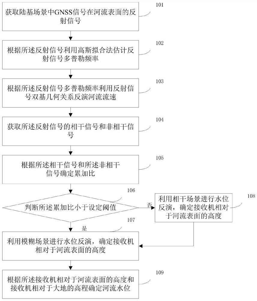
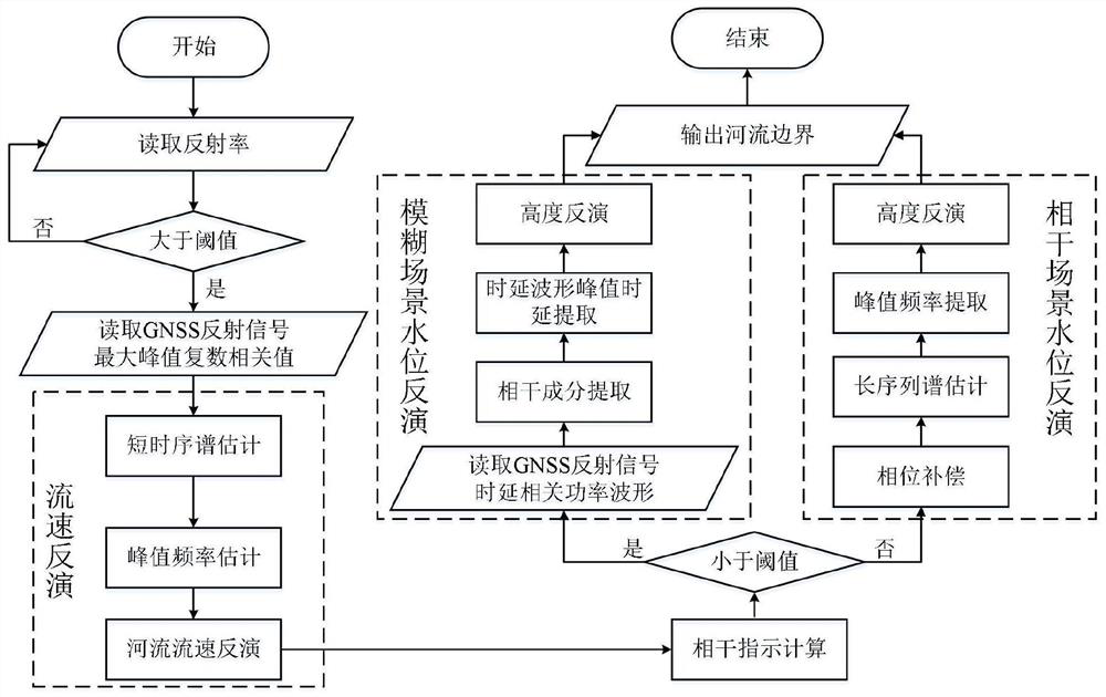
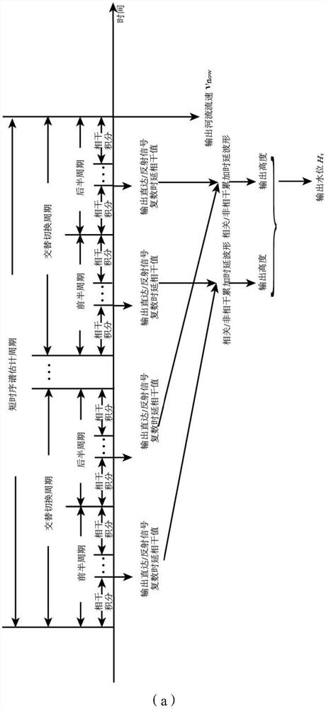
The invention relates to a river flow velocity and water level inversion method of a land-based GNSS reflectometer. The river flow velocity and water level inversion method comprises the following steps: acquiring a reflection signal of a GNSS signal on a river surface in a land-based scene; estimating the Doppler frequency of the reflected signal by using a Gaussian fitting method according to the reflected signal; according to the reflected signal Doppler frequency, inversing the river flow velocity by using a reflected signal bistatic geometrical relationship; obtaining a coherent signal and an incoherent signal of the reflected signal; determining an accumulation ratio according to the coherent signal and the incoherent signal; when the accumulation ratio is smaller than a set threshold value, using the fuzzy scene for water level inversion, and determining the height of the receiver relative to the river surface; when the accumulation ratio is greater than or equal to a set threshold value, performing water level inversion by using the coherent scene, and determining the height of the receiver relative to the river surface; and determining the river level according to the height of the receiver relative to the river surface and the elevation of the receiver relative to the ground. According to the invention, low-cost and high-precision detection of the flow velocity and the water level of the river can be realized.

Description

technical field [0001] The invention relates to the field of river measurement, in particular to a river velocity and water level inversion method of a land-based GNSS reflectometer. Background technique [0002] GNSS reflection signal (Global Navigation Satellite System-Reflection), which utilizes existing navigation satellite signals to realize inversion and monitoring of surface physical parameters through cooperative reception and processing of direct and ground-reflected navigation satellite signals, is a dual-base opportunity source The detection method has the advantages of low cost, low power consumption and light weight. Its L-band signal attenuation is small under rainfall conditions, which is suitable for monitoring under severe conditions such as rainfall. In addition, land-based detection can use mature multi-channel navigation radio frequency and correlator chips to complete signal processing to achieve rapid processing and monitoring. [0003] The current co...

Claims


Application Information

Patent Timeline
Patent Type & Authority Applications(China)
IPC IPC(8): G01S19/52G01S19/42G01F23/284
CPCG01S19/52G01S19/42G01F23/284Y02A90/30
Inventor 王峰邢进杨东凯张波
Owner BEIHANG UNIV
Learn More