Surveying instrument with GPS positioning module

A technology of GPS positioning and surveying and mapping instruments, which is applied in the field of surveying and mapping instruments, can solve the problems of cumbersome leveling of surveying and mapping instruments, delay of surveying and mapping time, unfavorable accuracy of staff, etc., and achieve the effects of auxiliary portability, convenient and quick assembly, quick connection and disassembly

Pending Publication Date: 2021-12-28
武汉鸿规勘测设计有限公司
View PDF0 Cites 0 Cited by
  • Summary
  • Abstract
  • Description
  • Claims
  • Application Information

AI Technical Summary

Problems solved by technology

[0004] The purpose of the present invention is to provide a surveying and mapping instrument with a GPS positioning module, so as to solve the cumbersome leveling of existing surveying and mappi

Method used


Image

  • Surveying instrument with GPS positioning module
  • Surveying instrument with GPS positioning module
  • Surveying instrument with GPS positioning module

Examples


Embodiment Construction

[0021] The following will clearly and completely describe the technical solutions in the embodiments of the present invention with reference to the accompanying drawings in the embodiments of the present invention. Obviously, the described embodiments are only some, not all, embodiments of the present invention. Based on the embodiments of the present invention, all other embodiments obtained by persons of ordinary skill in the art without making creative efforts belong to the protection scope of the present invention.

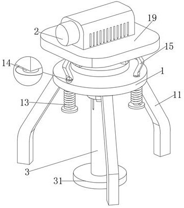
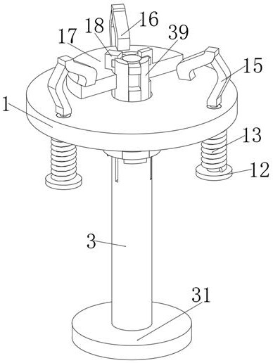
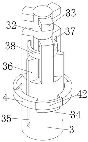
[0022] see Figure 1 to Figure 5 , the present invention provides a technical solution: the lower end of the central support disc 1 is uniformly provided with hinged support feet 11, and the middle support disc 1 is uniformly provided with a T-shaped adjustment column 12, and one end of the T-shaped adjustment column 12 is covered There is a tension spring 13, and a threaded connection column 14 welded to the middle side of the upper end of the T-shaped adjust...


PUM


Abstract

The invention relates to the technical field of surveying instruments, in particular to a surveying instrument with a GPS (global positioning system) positioning module, which is provided with a central stable column, so that a supporting point of the surveying instrument can be focused on a flat bottom, a worker can make a placement flat ground more conveniently in a complex environment; and meanwhile, under the action of adjustable supporting ground feet, the surveying instrument in a complex terrain can be supported; and further, the leveling time of the surveying instrument is greatly shorter than the time required by leveling the surveying instrument through a screw rod by virtue of the central stable column; through the structural arrangement of the center stable column, the center stable column and the surveying instrument can be quickly connected and disassembled, so that the portability of the surveying instrument is facilitated; and meanwhile, a worker can conveniently and quickly assemble the surveying instrument on a surveying and mapping site.

Description

technical field [0001] The invention relates to the technical field of surveying and mapping instruments, in particular to a surveying and mapping instrument with a GPS positioning module. Background technique [0002] The surveying and mapping instrument is a combination of light, machinery and electricity, which takes the workpiece into the computer and magnifies it by 18 to 230 times, and displays it on the screen. It can directly take pictures for archiving or do surface observation, measurement, and drawing. The measurement data can be used for SPC statistics. Create an EXCEL report, and the drawing file can be converted into an AUTOCAD application. The AUTOCAD graphics can also be transferred to the computer software to compare with the workpiece, and the data can be stored and printed on the computer, and can be transmitted through the network. At present, in order to better improve the measurement accuracy of the surveying instrument, the staff will install GPS insid...

Claims


Application Information

Patent Timeline
IPC IPC(8): F16M11/04F16M11/16F16M11/32G01C15/00
CPCF16M11/041F16M11/16F16M11/32G01C15/00
Inventor 郭慧娟
Owner 武汉鸿规勘测设计有限公司
Why Eureka
Try Eureka