Method for quickly and effectively judging crop area

A crop and area technology, applied in image data processing, measuring devices, instruments, etc., can solve the problems of affecting the calculation results, misreporting, omission, accuracy and authenticity cannot be guaranteed, etc., to improve the fault tolerance rate and improve the accuracy. Effect

Pending Publication Date: 2022-01-28
江苏天汇空间信息研究院有限公司
View PDF0 Cites 1 Cited by
  • Summary
  • Abstract
  • Description
  • Claims
  • Application Information

AI Technical Summary

Problems solved by technology

[0003] However, the traditional sampling measurement method is interfered by human factors in the process of data acquisition, and problems such as misreporting and missing reporting will inevitably occur. Since the overall calculation is obtained through sampling surveys, the deviations in the investigation process will directly affect the final calculation results. , the accuracy of the general sample survey area is between 60% and 90%;
[0004] In addition, the influence of satellite remote sensing weather and operation cycle will make it impossible to accurately obtain remote sensing images covering the entire survey area during the crop growth period. In addition, the accuracy is low due to the limitation of resolution; the high cost of aerial remote sensing makes it limited to a small area area, and it is difficult to obtain periodic aerial photos; the uncertainty of remote sensing image extraction technology also makes it impossible to independently complete the area measurement work with perfect statistical significance. Between 50% and 85%; there is no scientific and effective method for how to determine the sample size;
[0005] Finally, the traditional sampling survey relies on the data reported by the grassroots units, and the accuracy and authenticity cannot be guaranteed. The optical resolution of the current mainstream commercial satellite images is generally 0.5 meters, and the positioning accuracy is 0.5 to 1 meter, which cannot identify small crops. Area, the area below 0.5 mu is basically unrecognizable, and the accurate measurement of the sown area of ​​crops is also slightly lacking. However, the use of RTK with a centimeter-level positioning accuracy for on-the-spot measurement has too much workload and the area to be measured Due to terrain constraints, it is impossible to guarantee that all operations will be completed within the specified time

Method used


Image

  • Method for quickly and effectively judging crop area
  • Method for quickly and effectively judging crop area
  • Method for quickly and effectively judging crop area

Examples


Embodiment Construction

[0056] The following will clearly and completely describe the technical solutions in the embodiments of the present invention with reference to the accompanying drawings in the embodiments of the present invention. Obviously, the described embodiments are only some, not all, embodiments of the present invention. Based on the embodiments of the present invention, all other embodiments obtained by persons of ordinary skill in the art without making creative efforts belong to the protection scope of the present invention.

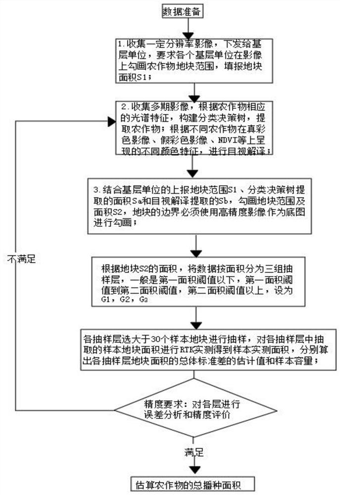
[0057] see figure 1 , the present invention provides a technical solution: a method for quickly and effectively judging the area of ​​crops, comprising the following steps:

[0058] Step S100: Collect data to be processed, the data to be processed includes panoramic images of crop areas and distinguishing features of crops; process the panoramic images of crop areas to obtain images of crop plots;

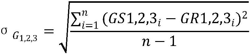
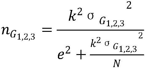
[0059] Step S110: Collect images of crop plots with a certai...


PUM


Abstract

The invention discloses a method for quickly and effectively judging the area of a crop. The method comprises the following steps of: collecting data, namely collecting an image with a certain resolution ratio, filling and reporting the area S1 of a land parcel, acquiring an area Sa and an area Sb visually interpreted by corresponding spectral characteristics through a classification decision tree, and acquiring an area set {S2} by combining the S1, the Sa and the Sb; layering the area set {S2} the land parcel, sampling each layer after layering, calculating sample capacity, and then randomly extracting sample land parcels for RTK actual measurement; and carrying out precision evaluation, respectively calculating the error rate of each layer, judging whether a result is within an allowable error rate, and if not, carrying out reprocessing to obtain an area set {S2}', and carrying out verification until the result is qualified; and finally, estimating the total sowing area of crops. According to the method, remote sensing and sampling investigation are integrated, and the accuracy of the land parcel area and the land parcel position is improved.

Description

technical field [0001] The invention relates to the technical field of remote sensing data measurement, in particular to a method for quickly and effectively judging the area of ​​crops. Background technique [0002] At present, two methods are mainly used for the statistics of the sown area of ​​crops: one is to use provinces, municipalities, and autonomous regions as the scope, and according to the principle of randomness, select survey outlets in multiple stages, conduct sampling and measurement of the sown area of ​​crops, and then go up step by step according to the sampling stage Calculate the sowing area; the second is to use remote sensing images to classify and extract the crops to obtain the sowing area of ​​the crops; [0003] However, the traditional sampling measurement method is interfered by human factors in the process of data acquisition, and problems such as misreporting and missing reporting will inevitably occur. Since the overall calculation is obtained ...

Claims


Application Information

Patent Timeline
Patent Type & Authority Applications(China)
IPC IPC(8): G06T7/62G01B11/28
CPCG06T7/62G01B11/28G06T2207/30188
Inventor 张业红顾行发刘向东黄祥志马紫玄陈键阳朱玉婷
Owner 江苏天汇空间信息研究院有限公司
Why Eureka
Try Eureka