Non-static 3D map view

A non-static, map technology, applied in the field of geological survey, can solve the problems of loose map box, unfavorable staff planning work concentration, unfavorable land use, etc., to avoid loosening and falling off.

Inactive Publication Date: 2022-02-15
陈健
View PDF0 Cites 0 Cited by
  • Summary
  • Abstract
  • Description
  • Claims
  • Application Information

AI Technical Summary

Problems solved by technology

[0002] Geological survey refers to the measurement of the area, altitude and other dimensions of a certain area through surveying and mapping, and finally through planning for subsequent development or environmental protection. At the same time, military research, teaching, geological rescue and mine display work are carried out. Sometimes it is necessary to use 3D map view. When it is necessary to use 3D map view, the existing 3D map view can only observe comprehensively due to the integrity of the plate when observing, and cannot carefully observe the particularity of a certain plate. , then it is easy to ignore the particularity of a certain place when planning, which is not conducive to the land use after planning, and the traditional 3D map view only has natural light or light on the top of the device for illumination when observing, so when targeting a certain place It is easy to be affected by the geological topography of other plates when observing the ground, which is not conducive to the concentration of the staff in planning work. At the same time, the topographic map plate in the traditional 3D map view will loosen with the map box after being used for a long time , is not conducive to long-term planning problems

Method used


Image

  • Non-static 3D map view
  • Non-static 3D map view
  • Non-static 3D map view

Examples


Embodiment Construction

[0033] The following will clearly and completely describe the technical solutions in the embodiments of the present invention with reference to the accompanying drawings in the embodiments of the present invention. Obviously, the described embodiments are only some, not all, embodiments of the present invention. Based on the embodiments of the present invention, all other embodiments obtained by persons of ordinary skill in the art without making creative efforts belong to the protection scope of the present invention.

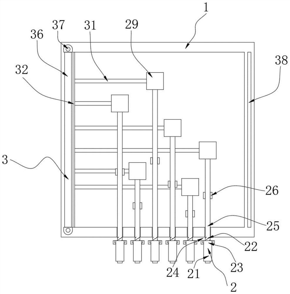
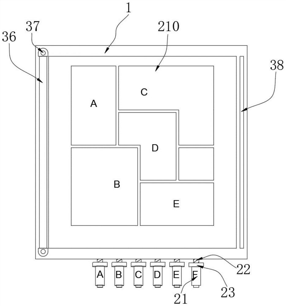
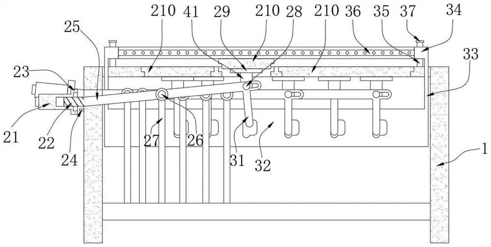
[0034] Such as figure 1 Shown:

[0035] A non-static 3D map view, including a map box 1 .

[0036] In this implementation plan: the existing 3D map view can only observe comprehensively due to the integrity of the plate when observing, and cannot carefully observe the particularity of a certain plate, so it is easy to ignore the particularity of a certain place when planning It is not conducive to land use after planning, and the traditional 3D map view only...


PUM


Abstract

The invention belongs to the technical field of geological survey, and particularly relates to a non-static 3D map view which comprises a map box body and further comprises a lifting assembly arranged on one side of the map box body, and the lifting assembly comprises a handle, a threaded rod, a ring cylinder, a positioning strip, a lever, a rotating shaft, a stabilizing rod, a connecting shaft, a connecting plate and map plates. The map plates can be separated and lifted by the lifting assembly , workers can effectively observe topographic features of a certain place, effective illumination work can be carried out on the lifted map plates through cooperative work of the illumination assembly and the lifting assembly, the workers can concentrate on planning work of the place, through the connection work of a clamping head arranged on a connecting assembly and a connecting column, the connecting assembly and the lifting assembly can be stably connected, and the situation that the map plate looses and falls off in a long-term planning project is avoided.

Description

technical field [0001] The invention belongs to the technical field of geological survey, and in particular relates to a non-static 3D map view. Background technique [0002] Geological survey refers to the measurement of the area, altitude and other dimensions of a certain area through surveying and mapping, and finally through planning for subsequent development or environmental protection. At the same time, military research, teaching, geological rescue and mine display work are carried out. Sometimes it is necessary to use 3D map view. When it is necessary to use 3D map view, the existing 3D map view can only observe comprehensively due to the integrity of the plate when observing, and cannot carefully observe the particularity of a certain plate. , then it is easy to ignore the particularity of a certain place when planning, which is not conducive to the land use after planning, and the traditional 3D map view only has natural light or light on the top of the device for...

Claims


Application Information

Patent Timeline
Patent Type & Authority Applications(China)
IPC IPC(8): G09B29/00
CPCG09B29/005
Inventor 陈健崔凤孙彩虹
Owner 陈健
Why Eureka
Try Eureka