Three-dimensional digital road network construction method based on BIM and GIS technologies

A three-dimensional digital and road network technology, applied in the field of three-dimensional road network, can solve the problems of integrated processing and analysis of difficult road attributes and spatial data, slow construction speed, and high error rate, so as to facilitate browsing and post-processing, and improve reliability. and fault tolerance, improving accuracy and efficiency

Pending Publication Date: 2022-03-01
YUNNAN YUNLING HIGHWAY ENG CONSULTING CO LTD
View PDF0 Cites 0 Cited by
  • Summary
  • Abstract
  • Description
  • Claims
  • Application Information

AI Technical Summary

Problems solved by technology

[0003] The traditional use of computers to manage highways is limited to text table processing, and a large amount of information query and information processing, especially the analysis and processing of spatial information, still stays on traditional drawings, and it is difficult to realize the integration of highway attributes and spatial data. Comprehensive processing and analysis, let alone visualization and virtual reality, the establishment of a 3D digital road network can improve the convenience of planning, design and management of the road network, but the existing 3D digital road network construction speed based on BIM and GIS technology is relatively slow, The efficiency is low, the fusion and connection between models cannot be well realized, and it is difficult to meet the requirements of visual observation. At the same time, the error rate is high in the complicated process, and the quality cannot be guaranteed. Therefore, a technology based on BIM and GIS is designed. 3D digital road network construction method to solve the above problems

Method used


Image

  • Three-dimensional digital road network construction method based on BIM and GIS technologies
  • Three-dimensional digital road network construction method based on BIM and GIS technologies

Examples


Embodiment Construction

[0023] In order to make the object, technical solution and advantages of the present invention clearer, the present invention will be further described in detail below in conjunction with the accompanying drawings and embodiments. It should be understood that the specific embodiments described here are only used to explain the present invention, not to limit the present invention.

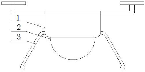
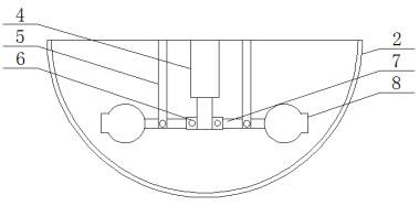
[0024] refer to Figure 1-2 , a three-dimensional digital road network construction method based on BIM and GIS technology, including a multi-camera drone, the multi-camera drone includes a body 1, a transparent protective cover 2 is fixed on the lower end of the body 1, and the transparent protective cover 2 is made of acrylic material Made, the transparent protective cover 2 plays the role of protecting the camera 8 and helping to take pictures, five cameras 8 are arranged in the transparent protective cover, one end of the camera 8 is provided with an angle adjustment device, and both sides of t...


PUM


Abstract

The invention discloses a three-dimensional digital road network construction method based on BIM and GIS technologies, and the method comprises the following steps: a multi-lens unmanned aerial vehicle is included, the multi-lens unmanned aerial vehicle comprises a vehicle body, a transparent protection cover is fixed at the lower end of the vehicle body, five cameras are arranged in the transparent protection cover, one end of each camera is provided with an angle adjusting device, and the other end of each camera is provided with an angle adjusting device; undercarriages are fixed to the two sides of the lower end of the vehicle body, and the three-dimensional digital road network construction method comprises the following steps that S1, partition operation is conducted, oblique photography aerial survey operation is conducted through a multi-lens unmanned aerial vehicle, the aerial survey range of a project is determined, and the aerial survey landform is known. According to the method, the construction of the three-dimensional digital road network model can be quickly and efficiently completed, the building and road model and the terrain model can be well fused and joined, the visual observation requirement is met, the visualization effect of the three-dimensional digital environment is greatly improved, the reliability and the error-tolerant rate are improved, and the method is suitable for popularization and application. And the construction speed and quality of the three-dimensional digital road network model are effectively improved.

Description

technical field [0001] The invention relates to the technical field of three-dimensional road network, in particular to a three-dimensional digital road network construction method based on BIM and GIS technology. Background technique [0002] Geographic Information System (GIS) is sometimes called "Geological Information System". It is a specific and very important spatial information system. A technical system that collects, stores, manages, calculates, analyzes, displays, and describes geographically distributed data in space. Building Information Modeling (BIM) is a complete information model that can integrate different engineering projects in their entire life cycle. The engineering information, process and resources of each stage are integrated in one model, which is conveniently used by all parties involved in the project. Simulate the real information of buildings through 3D digital technology, and provide a coordinated and internally consistent information model f...

Claims


Application Information

Patent Timeline
Patent Type & Authority Applications(China)
IPC IPC(8): G06T17/05G06F16/29G06F30/13B64C39/02B64D47/08
CPCG06T17/05G06F16/29G06F30/13B64D47/08B64C39/024B64U2101/30
Inventor 郭峰江鸥闫文佳张金丽杨荣焕江琦李荣峰李雨峰刘昌文汪欣
Owner YUNNAN YUNLING HIGHWAY ENG CONSULTING CO LTD
Why Eureka
Try Eureka