Grassland vegetation coverage estimation and prediction method based on remote sensing

A grassland vegetation and prediction method technology, which is applied in calculation, complex mathematical operations, instruments, etc., can solve the problems of high cost, inability to quickly and accurately estimate and predict grassland vegetation coverage, long cycle, etc., and achieve the effect of improving the long cycle

Pending Publication Date: 2022-04-08
LIAONING TECHNICAL UNIVERSITY +1
View PDF0 Cites 2 Cited by
  • Summary
  • Abstract
  • Description
  • Claims
  • Application Information

AI Technical Summary

Problems solved by technology

[0004] The purpose of the present invention is to solve the technical problem that the existing observation method of grassland vegetation coverage has a long cycle and high cost, and cannot quickly and accurately estimate and predict the grassland vegetation coverage in the future area, and provides a grassland vegetation coverage based on remote sensing Estimation and Forecasting Methods

Method used


Image

  • Grassland vegetation coverage estimation and prediction method based on remote sensing
  • Grassland vegetation coverage estimation and prediction method based on remote sensing
  • Grassland vegetation coverage estimation and prediction method based on remote sensing

Examples


specific Embodiment approach 1

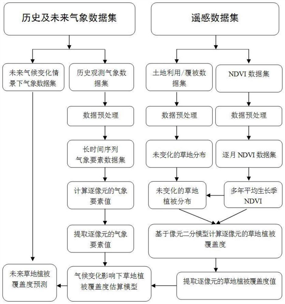
[0031] Specific implementation mode 1: In this implementation mode, a method for estimating and predicting grassland vegetation coverage based on remote sensing is carried out according to the following steps:

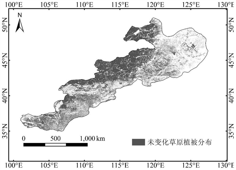
[0032] Step 1. Obtain the ten-day normalized difference vegetation index NDVI data set covering the study area within a certain period of time, the historical surface observation meteorological data set, the meteorological data set under the future climate change scenario, and the two-period land use / cover data set, and Preprocess the data;

[0033] Step 2: Use the maximum value synthesis method to set the NDVI data set by ten days into a monthly NDVI data set, and use the arithmetic mean method to calculate the average growth season NDVI value for a certain period of time;

[0034] Step 3: Using the ordinary kriging interpolation method, the historical surface observation meteorological data set is subjected to spatial interpolation processing and resampled to extract...

specific Embodiment approach 2

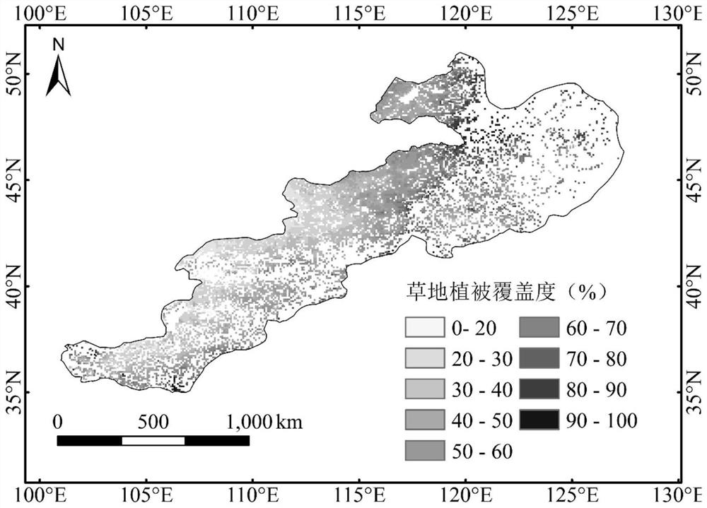
[0042] Specific embodiment two: the difference between this embodiment and specific embodiment one is that the pixel dichotomy model formula described in step seven is as follows:

[0043]

[0044] Among them, FVC is the coverage of grassland vegetation by pixel, NDVI is the NDVI value of the average growth season for many years in a certain period of time, and NDVI soil NDVI is the pixel information of completely bare and no vegetation coverage in the grassland distribution area soil , NDVI wg It is pure vegetation pixel information. Others are the same as the first embodiment.

specific Embodiment approach 3

[0045] Specific implementation mode three: the difference between this implementation mode and specific implementation mode one or two is that step nine uses multiple stepwise regression analysis to construct a pixel-by-pixel grassland vegetation coverage estimation model under the influence of climate change, and select the fitting coefficient value The largest model is used as the final grassland vegetation coverage estimation model, and the formula is as follows:

[0046] FVC=a+a 1 x 1 +a 2 x 2 +a 3 x 3 +...a k x k Formula (2)

[0047] Among them, FVC is the coverage of grassland vegetation per pixel, a is a constant term, and a 1 , a 2 , a 3 ,...a k is the regression coefficient, X 1 , X 2 , X 3 ,...X k is the value of each meteorological element in a certain period of time. Others are the same as those in Embodiment 1 or 2.


PUM


Abstract

The invention discloses a grassland vegetation coverage estimation and prediction method based on remote sensing, and relates to a method for estimating and predicting grassland vegetation coverage by using remote sensing and meteorological data. The problems that an existing grassland vegetation coverage observation method is long in period and high in cost, and the future grassland vegetation coverage cannot be accurately predicted are solved. The method comprises the steps of obtaining and preprocessing a remote sensing and meteorological data set; performing spatial interpolation processing on the historical observation meteorological data set; extracting unchanged grassland vegetation distribution as a research area; calculating grassland vegetation coverage per pixel by using a pixel bipartite model; extracting grassland vegetation coverage and meteorological element values of pixel-by-pixel in the research area; constructing a grassland vegetation coverage estimation model under the influence of climate change by using multiple stepwise regression; and predicting the future grassland vegetation coverage in combination with the meteorological data under the future climate change scene. The characteristics that remote sensing data are easy to obtain and large in spatial scale are utilized, and a new method is provided for grassland vegetation coverage estimation and prediction.

Description

technical field [0001] The invention relates to a method for estimating and predicting grassland vegetation coverage based on remote sensing, in particular to a method for estimating grassland vegetation coverage by pixel by using remote sensing data and historical ground observation meteorological data under the influence of climate change. Grassland vegetation coverage, combined with meteorological data under future climate change scenarios, to predict the method of future regional grassland vegetation coverage. Background technique [0002] Grassland is one of the largest terrestrial ecosystems on earth, which can effectively reduce soil erosion, windbreak and sand fixation, and prevent soil salinization. Vegetation is an important part of terrestrial ecosystems. It can not only represent land cover changes to a certain extent, but also play an important role in maintaining ecosystem functions, protecting biodiversity, and balancing surface energy. Grassland vegetation, ...

Claims


Application Information

Patent Timeline
Patent Type & Authority Applications(China)
IPC IPC(8): G06F17/18G06Q50/26
CPCY02A90/10
Inventor 马蓉夏春林神祥金张佳琦吕宪国
Owner LIAONING TECHNICAL UNIVERSITY
Why Eureka
Try Eureka