Land space planning and compiling collaborative design platform based on spatial data subdivision

A technology of spatial data and spatial planning, which is applied in the field of natural resource management systems, can solve problems such as low efficiency, and achieve the effect of increasing speed and improving efficiency

Pending Publication Date: 2022-04-12
重庆市规划设计研究院
View PDF0 Cites 3 Cited by
  • Summary
  • Abstract
  • Description
  • Claims
  • Application Information

AI Technical Summary

Problems solved by technology

[0009] The present invention intends to provide a collaborative design platform for land and space planning compilation based on spatial data subdivision to solve the problem of low efficiency existing in planning compilation based on GIS

Method used


Image

  • Land space planning and compiling collaborative design platform based on spatial data subdivision
  • Land space planning and compiling collaborative design platform based on spatial data subdivision
  • Land space planning and compiling collaborative design platform based on spatial data subdivision

Examples


Embodiment 1

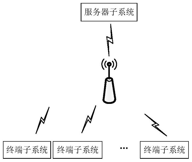
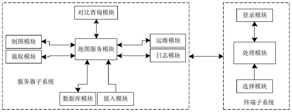
[0036] Collaborative design platform for territorial spatial planning compilation based on spatial data segmentation, such as figure 1 and figure 2 Shown: includes server subsystem and multiple terminal subsystems, server subsystem includes mapping module, comparison query module, access module, database module, map service module and interception module, terminal subsystem includes login module, selection module and processing Module, this platform uses C / S architecture to build the corresponding overall architecture. The server subsystem is located in the background or cloud, and the terminal subsystem is located in the user. The terminal subsystems at the county level, prefectural level and provincial level can use existing PC hosts, monitors and peripherals for input.

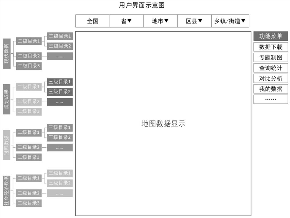
[0037] The mapping module is used to generate map data of land space and store it in the database module. The mapping module draws map data through GIS software. The map data is compared, viewed and disp...

Embodiment 2

[0049] The difference from Embodiment 1 is that the server subsystem also includes an overlay comparison module and an upload module, and the processing module obtains the login authority identifier of the login module and sends it to the map service module, and the map service module will process the data elements generated by each terminal subsystem Separately form layer elements and store them. The map service module obtains the authorization elements in the database module according to the login authorization identifier to form an authorization layer, and sends the layer elements and authorization layers to the overlay comparison module, and the overlay comparison module compares each terminal The layer elements of the subsystem are overlaid and compared with the authority layer. The overlay comparison module generates difference spots in the areas that do not overlap between the layer elements and the authority layer. The difference spots are obtained by overlapping and com...


PUM


Abstract

The invention relates to the field of natural resource management systems, in particular to a territorial space planning and compiling collaborative design platform based on spatial data subdivision, which comprises a server subsystem and a plurality of terminal subsystems, and is characterized in that the server subsystem comprises a database module, a map service module and an interception module; the terminal subsystem comprises a login module, a selection module and a processing module; the selection module is used for acquiring a spatial range and data elements from the data directory tree, and the processing module acquires the spatial range and the data elements and sends the spatial range and the data elements to the map service module; the interception module retrieves data contents in the database module according to the spatial range and the data elements of the map service module, and cuts or splices the data contents and the data elements according to the spatial position relationship to generate the data elements in the same level of spatial range; and the map service module obtains the generated data elements and sends the data elements to the terminal subsystem for use. According to the invention, the collaboration among the data of each terminal subsystem is improved.

Description

technical field [0001] The invention relates to the field of natural resource management systems, in particular to a collaborative design platform for national land space planning compilation based on spatial data division. Background technique [0002] Land space planning is the development and protection of land space in a certain area, and the arrangements made in space and time. It is a guide for the development of space resources, a spatial blueprint for sustainable development, and the basic basis for various development, protection and construction activities. The preparation of national land space planning requires multi-level and multi-category planning work, for example, it is divided into five levels: national level, provincial level, city level, county level and township level, and divided into three categories: overall planning, detailed planning and special planning . [0003] The compilation of land and space planning is currently based on the Geographic Info...

Claims


Application Information

Patent Timeline
Patent Type & Authority Applications(China)
IPC IPC(8): G06F16/29G06F16/9537G06F16/2455G06F16/2453
Inventor 李乔卢涛黄芸璟李继珍杨乐左俊杰张臻
Owner 重庆市规划设计研究院
Why Eureka
Try Eureka