Flood detection method based on Beidou satellite L4 and CMC combined observation value

A combined observation and Beidou satellite technology, applied in the field of navigation satellite remote sensing inversion, can solve problems such as the failure of flood detection method, non-providance, etc. Effect

Active Publication Date: 2022-04-15
HANGZHOU DIANZI UNIV
View PDF12 Cites 0 Cited by
  • Summary
  • Abstract
  • Description
  • Claims
  • Application Information

AI Technical Summary

Problems solved by technology

[0004] The purpose of the present invention is to provide a flood detection method based on the combined observation value of Beidou L4 and CMC, which can effectively detect floods by using existing Beidou navigation system satellites and low-cost receivers, which can greatly improve the detection efficiency of floods. At the same time, it can solve the problem that the low-end receiver does not provide the carrier-to-noise ratio observation value, which leads to the failure of the flood detection method based on the carrier-to-noise ratio

Method used


Image

  • Flood detection method based on Beidou satellite L4 and CMC combined observation value
  • Flood detection method based on Beidou satellite L4 and CMC combined observation value
  • Flood detection method based on Beidou satellite L4 and CMC combined observation value

Examples


Embodiment 1

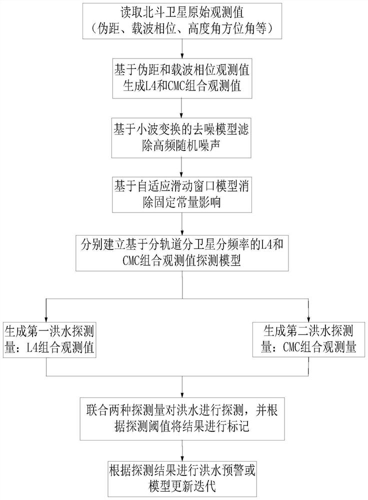
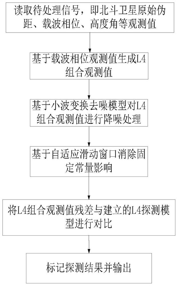
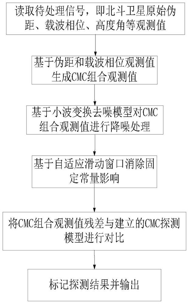
[0055] Step 1: Extract the original observations of Beidou navigation system satellites, including pseudoranges and carrier phase observations, and calculate the corresponding altitude angle, azimuth angle and other information of the satellites.

[0056] Step 2: Calculate L4 and CMC combined observations based on pseudorange and carrier phase observations, respectively. The calculation model of L4 combination observation value is as follows:

[0057] L4≡L1-L2 (1)

[0058] Among them, L1 and L2 represent the carrier phase observations of Beidou B1 and B2 frequency bands respectively. The calculation model of CMC combined observation value is expressed as follows:

[0059] CMC=P-λφ=ρ+c(δt r -δt s )+I+T+λN+M+ε (2)

[0060] Among them, P is the pseudo-range observation value of Beidou satellite B1 frequency band, λ is the wavelength of B1 frequency band, and φ represents the carrier phase observation value of B1 frequency band. p represents the geometric distance between th...


PUM


Abstract

The invention mainly provides a flood detection method based on a Beidou navigation system satellite L4 and CMC combined observation value, and the method can effectively solve a problem that a flood detection method based on a Beidou satellite carrier-to-noise ratio fails because a low-end receiver does not output a carrier-to-noise ratio observation value. And meanwhile, the success rate and the accuracy rate of flood detection are improved through combined detection of double combination observation values. Severe multipath signals can be generated by Beidou signals due to surface ponding, the multipath signals can directly influence L4 and CMC combined observation values, the L4 combined observation values are directly influenced by multipath of Beidou satellite carrier signals, and the CMC combined observation values are directly influenced by multipath of Beidou satellite pseudo-range signals. Therefore, joint detection can be carried out on the flood by using the L4 and CMC combined observation value.

Description

technical field [0001] The present invention describes a flood detection method based on combined observation values ​​of Beidou satellite L4 (dual-frequency geometry-freelinear combination, referred to as L4) and CMC (code-minus-carrier combination, referred to as CMC) , belongs to the technical field of navigation satellite remote sensing inversion. Background technique [0002] In recent years, disasters such as local flooding or urban waterlogging caused by extreme heavy rainfall have occurred frequently. People's life safety and economic development have had a great impact. Therefore, how to quickly, accurately and timely detect and monitor floods, and provide strong support for the government and flood control authorities, so as to maximize the protection of people's lives and economic construction, is one of the current problems that need to be solved urgently. [0003] At present, there are three main methods for detecting floods: 1) Rainfall monitoring stations ba...

Claims


Application Information

Patent Timeline
Patent Type & Authority Applications(China)
IPC IPC(8): G01S19/44G01S19/25G01S19/29
Inventor 苏明坤杨艳茜乔磊张欢滕旭阳宋慧娜
Owner HANGZHOU DIANZI UNIV
Why Eureka
Try Eureka