Regional soil humidity monitoring method based on equivalent rainfall estimation method

A soil moisture and equivalent technology, applied in measurement devices, measurement of scattering characteristics, re-radiation of electromagnetic waves, etc., can solve the problem of poor optical image penetration, difficulty in monitoring large-area soil moisture, and easy to be affected by weather, etc. problem, to achieve the effect of high-precision detection of soil moisture

Pending Publication Date: 2022-04-26
NORTH CHINA INST OF AEROSPACE ENG
View PDF0 Cites 0 Cited by
  • Summary
  • Abstract
  • Description
  • Claims
  • Application Information

AI Technical Summary

Problems solved by technology

[0003] At present, there are two main monitoring methods of soil moisture, the traditional field measurement method and the remote sensing method. Monitoring soil moisture solves the shortcomings of traditional methods by virtue of its advantages of wide monitoring range, fast timeliness, and long-term dynamic monitoring
Remote sensing data mainly include optical remote sensing and microwave remote sensing. Among them, optical remote sensing data is easy to obtain, and the vegetation index constructed by optical data can accurately estimate the vegetation water content information to achieve the effect of removing vegetation layer images, but the optical image has poor penetration ability. , and is easily affected by the weather. The vegetation and roughness of the surface cover also affect the scope of use of optical remote sensing, while synthetic aperture radar can penetrate the atmosphere and vegetation layers, and is not affected by bad weather. Earth observation has a great advantage in observing the surface, especially the soil. The backscatter coefficient obtained by radar has a direct relationship with the dielectric constant. The change of soil moisture affects the change of the dielectric constant. Soil The study of moisture has a good prospect. In the prior art, there is no better method that can use microwave remote sensing and optical remote sensing to monitor soil moisture at the same time.

Method used


Image

  • Regional soil humidity monitoring method based on equivalent rainfall estimation method
  • Regional soil humidity monitoring method based on equivalent rainfall estimation method
  • Regional soil humidity monitoring method based on equivalent rainfall estimation method

Examples


Embodiment Construction

[0038] The following will clearly and completely describe the technical solutions in the embodiments of the present invention with reference to the accompanying drawings in the embodiments of the present invention. Obviously, the described embodiments are only some, not all, embodiments of the present invention. Based on the embodiments of the present invention, all other embodiments obtained by persons of ordinary skill in the art without making creative efforts belong to the protection scope of the present invention.

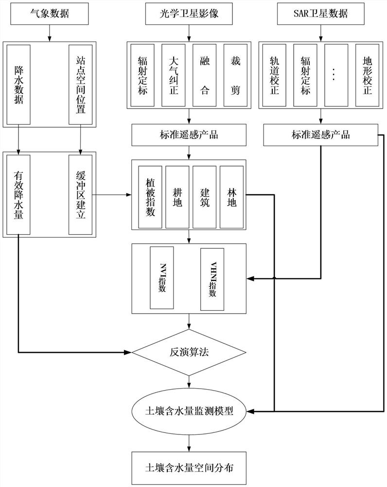
[0039] The purpose of the present invention is to provide a regional soil moisture monitoring method based on the equivalent precipitation estimation method, which combines radar images and optical images to realize regional soil moisture monitoring, and does not require actual soil moisture as prior knowledge, saving manpower and material resources.

[0040] In order to make the above objects, features and advantages of the present invention more comprehensib...


PUM


Abstract

The invention provides a regional soil humidity monitoring method based on an equivalent rainfall estimation method, which comprises the following steps of: firstly, acquiring a satellite image of a test region, generating backscattering coefficient image data and normalized vegetation index image data, establishing a plurality of buffer regions, classifying land utilization types of the buffer regions, and acquiring corresponding vector data; performing mask extraction on the backscattering coefficient image data and the normalized vegetation index image data through vector data to obtain corresponding data of two polarization directions of a radar backscattering coefficient and normalized vegetation index data, and obtaining meteorological data before the image; and analyzing the meteorological data, the data of the two polarization directions of the backscattering coefficient and the normalized vegetation index data to obtain an equivalent precipitation model related to the soil humidity, and calculating the soil humidity. According to the regional soil humidity monitoring method based on the equivalent rainfall estimation method, radar images and optical images are combined, and regional soil humidity monitoring can be achieved.

Description

technical field [0001] The invention relates to the technical field of soil moisture quantitative inversion, in particular to a regional soil moisture monitoring method based on an equivalent precipitation estimation method. Background technique [0002] Soil moisture is the main control variable of water and energy cycles on the earth's surface. It plays an important role in the transfer of water and heat and energy exchange between the land-atmosphere interface. One of the important indicators of production estimation. [0003] At present, there are two main monitoring methods of soil moisture, the traditional field measurement method and the remote sensing method. Monitoring soil moisture solves the shortcomings of traditional methods by virtue of its advantages of wide monitoring range, fast timeliness, and long-term dynamic monitoring. Remote sensing data mainly include optical remote sensing and microwave remote sensing. Among them, optical remote sensing data is eas...

Claims


Application Information

Patent Timeline
Patent Type & Authority Applications(China)
IPC IPC(8): G01N21/47G01S7/48G01S17/90
CPCG01N21/47G01S7/4802G01S17/90G01N2021/4735
Inventor 王延仓张亮张焱林家禄崔钰毕博文张文豪刘玉燕李国洪
Owner NORTH CHINA INST OF AEROSPACE ENG
Why Eureka
Try Eureka