Mine personnel positioning method based on digital twinning
A personnel positioning and mine technology, applied in positioning, climate sustainability, instruments, etc., can solve the problems of limited use, difficult positioning, unusable WiFi technology and RFID technology, etc., to achieve accurate positioning and avoid limitations.
- Summary
- Abstract
- Description
- Claims
- Application Information
AI Technical Summary
Problems solved by technology
Method used
Image

Examples
Embodiment 1
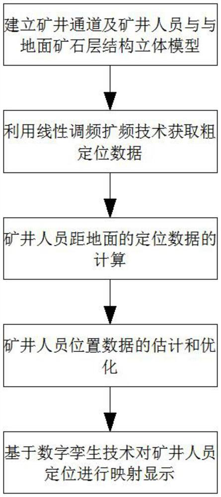
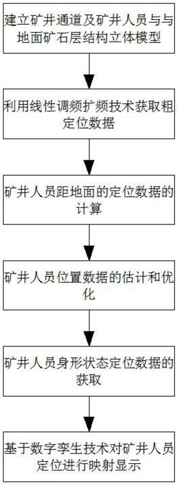
[0034] according to Figure 1 、 Figure 2 As shown in the present embodiment, the present embodiment provides a method of positioning the mine personnel based on a digital twin, comprising the following steps:
[0035] Step 1: Based on the principle of electromagnetic induction, the ore composition between the mine personnel and the ground is detected, and the radar image obtained by the remote sensing satellite is combined to establish a three-dimensional model of the ore layer structure under the mine and between the mine personnel and the ground;
[0036] After the remote sensing satellite acquires the radar image, the interference of the coherent signal is reduced by the enhanced Lee filter transformation, and then the mean filter is further used to smooth the radar image, and the Lee filter model is represented by the following equation
[0037]
[0038] where W(t) represents the weight function, C 1 and C v The data z(t) and the standard deviation coefficient of the noise, r...
Embodiment 2
[0049] according to Figure 3 As shown in the present embodiment, the present embodiment provides a method of positioning the mine personnel based on a digital twin, comprising the following steps:
[0050] Step 1: Based on the principle of electromagnetic induction, the ore composition between the mine personnel and the ground is detected, and the radar image obtained by the remote sensing satellite is combined to establish a three-dimensional model of the ore layer structure under the mine and between the mine personnel and the ground;
[0051] After the remote sensing satellite acquires the radar image, the interference of the coherent signal is reduced by the enhanced Lee filter transformation, and then the mean filter is further used to smooth the radar image, and the Lee filter model is represented by the following equation
[0052]
[0053] where W(t) represents the weight function, C 1 and C v The data z(t) and the standard deviation coefficient of the noise, respectively...
PUM
 Abstract
Description
Claims
Application Information
 - R&D
- Intellectual Property
- Life Sciences
- Materials
- Tech Scout
- Unparalleled Data Quality
- Higher Quality Content
- 60% Fewer Hallucinations
Browse by: Latest US Patents, China's latest patents, Technical Efficacy Thesaurus, Application Domain, Technology Topic, Popular Technical Reports.
© 2025 PatSnap. All rights reserved.Legal|Privacy policy|Modern Slavery Act Transparency Statement|Sitemap|About US| Contact US: help@patsnap.com