Satellite remote sensing image irregular scatter on-satellite resampling processing algorithm and system

A technology for satellite remote sensing and remote sensing images, which is applied in the field of on-board data to achieve the effect of simple structure and easy implementation.

Pending Publication Date: 2022-05-24
SHANGHAI SATELLITE ENG INST
View PDF0 Cites 0 Cited by
  • Summary
  • Abstract
  • Description
  • Claims
  • Application Information

AI Technical Summary

Problems solved by technology

None of the existing methods are suitable for on-board resampling of satellite remote sensing images with irregular scattered points

Method used


Image

  • Satellite remote sensing image irregular scatter on-satellite resampling processing algorithm and system
  • Satellite remote sensing image irregular scatter on-satellite resampling processing algorithm and system
  • Satellite remote sensing image irregular scatter on-satellite resampling processing algorithm and system

Examples


Embodiment Construction

[0050] The present invention will be described in detail below with reference to specific embodiments. The following examples will help those skilled in the art to further understand the present invention, but do not limit the present invention in any form. It should be noted that, for those skilled in the art, several changes and improvements can be made without departing from the inventive concept. These all belong to the protection scope of the present invention.

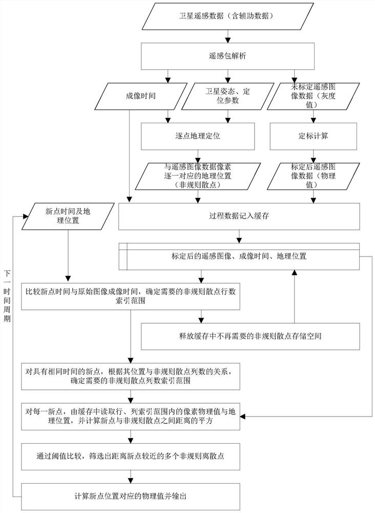
[0051] like figure 1 As shown, a resampling processing algorithm on irregular scatter satellite images of satellite remote sensing images provided by the present invention includes the following steps:

[0052] Step 1: The on-board processing module receives the original remote sensing data packets of the satellite, and analyzes the remote sensing packets, obtains satellite attitude parameters, satellite positioning parameters, and uncalibrated remote sensing image data values, and calculates the imaging time. ...


PUM


Abstract

The invention provides a satellite remote sensing image irregular scatter on-satellite resampling processing algorithm and system, and the algorithm comprises the steps: obtaining a satellite attitude parameter, a satellite positioning parameter and an uncalibrated remote sensing image data value, and calculating the imaging time; acquiring geographic position coordinates corresponding to the remote sensing image data pixels one by one; converting the uncalibrated remote sensing image into calibrated image data with physical significance and dimension; recording the imaging time, the calibrated remote sensing data and the geographic position information into a cache; determining a required irregular scatter row number index range, and releasing irregular scatter storage space which is not required any more in the cache; determining a column number index range of irregular scattered points required by each new point; calculating the square of the spatial distance between the new point and the irregular point; screening out a plurality of irregular discrete points closer to the new points; and calculating and outputting a physical value corresponding to the position of the new point. The method is simple in structure, is easy to realize on a satellite, and can be widely applied to on-satellite resampling processing of irregular scatter points.

Description

technical field [0001] The invention relates to the technical field of on-board data, in particular, to an on-board resampling processing algorithm and system for irregular scattered points of satellite remote sensing images. Background technique [0002] With the development of remote sensing technology, the real-time and high-efficiency acquisition of satellite information by remote sensing satellite users is getting higher and higher, which makes it necessary to process, fuse, and extract information on the satellite. Onboard processing may involve different methods for different purposes. For imaging remote sensing satellites, how to resample is one of the more common problems in the field of remote sensing image processing. For resampling of regular lattice points, existing projection and interpolation methods can be applied. For satellite remote sensing images, the sampling points are affected by the load imaging method, the curvature of the earth, satellite attitude...

Claims


Application Information

Patent Timeline
Patent Type & Authority Applications(China)
IPC IPC(8): G06V20/13G06V10/22G06F16/51G06F16/583G06F16/587
CPCG06F16/51G06F16/583G06F16/587
Inventor 郭玲玲汪少林代海山周军林两魁杨春燕何军
Owner SHANGHAI SATELLITE ENG INST
Why Eureka
Try Eureka