Multi-sensor fusion positioning method of vehicle navigation system

A vehicle navigation system and multi-sensor fusion technology, applied in the field of vehicle navigation, can solve the problems of high navigation cost and low navigation system accuracy, and achieve the effects of improving filtering positioning accuracy, saving computing resources, and suppressing divergence

Pending Publication Date: 2022-05-27
SAIC MOTOR
View PDF8 Cites 0 Cited by
  • Summary
  • Abstract
  • Description
  • Claims
  • Application Information

AI Technical Summary

Problems solved by technology

[0004] The purpose of the present invention is to solve the problem that the navigation system of the vehicle in the prior art has low precision, and the navigation cost is high by using the differential signal enhancement technology

Method used


Image

  • Multi-sensor fusion positioning method of vehicle navigation system
  • Multi-sensor fusion positioning method of vehicle navigation system
  • Multi-sensor fusion positioning method of vehicle navigation system

Examples


Embodiment Construction

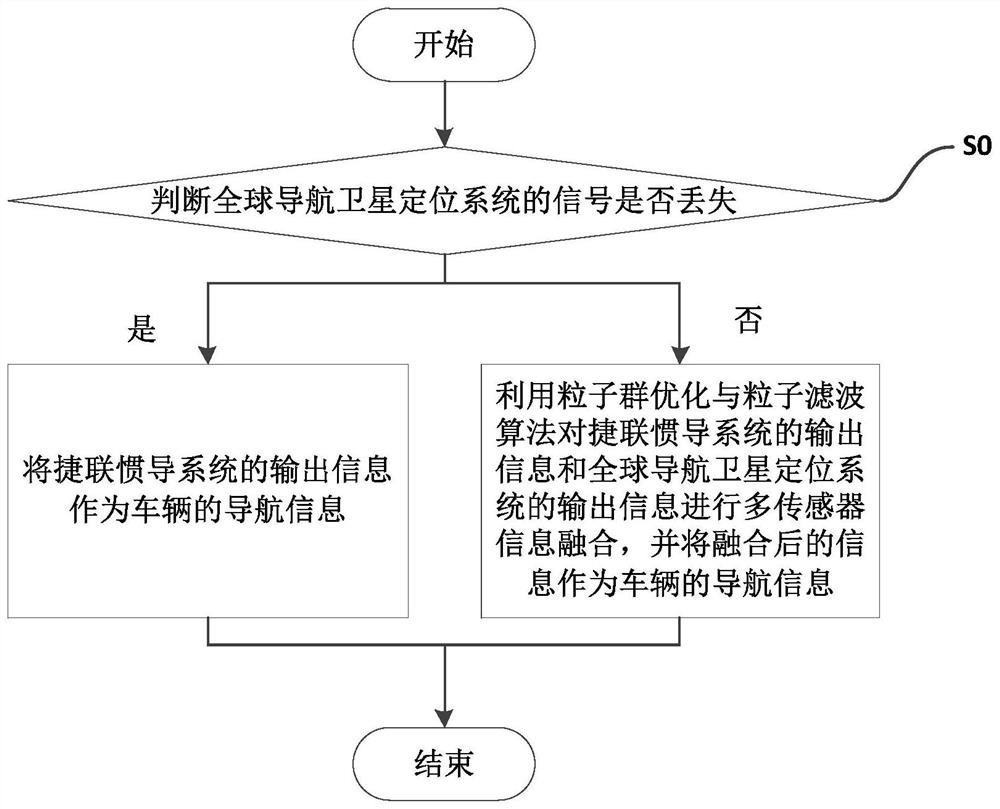
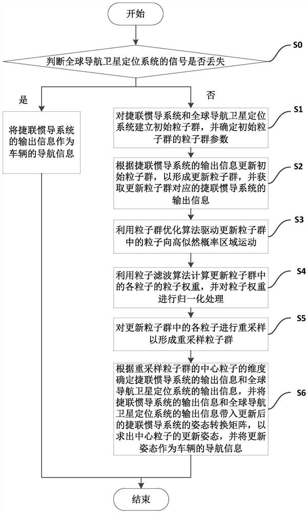
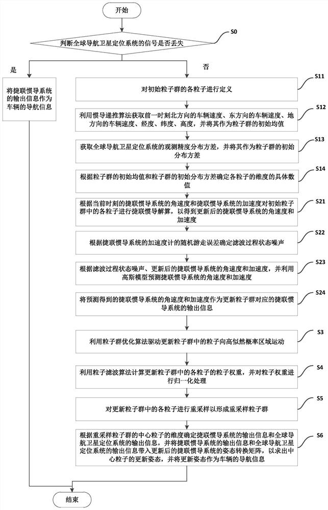
[0084] The embodiments of the present invention are described below by specific embodiments, and those skilled in the art can easily understand other advantages and effects of the present invention from the contents disclosed in this specification. Although the description of the invention will be presented in conjunction with the preferred embodiment, this does not mean that the features of the invention are limited to this embodiment. On the contrary, the purpose of introducing the invention in conjunction with the embodiments is to cover other options or modifications that may be extended based on the claims of the invention. The following description will contain numerous specific details in order to provide a thorough understanding of the present invention. The invention may also be practiced without these details. Also, some specific details will be omitted from the description in order to avoid obscuring or obscuring the gist of the present invention. It should be not...


PUM


Abstract

The invention provides a multi-sensor fusion positioning method of a vehicle navigation system, the vehicle navigation system comprises a strapdown inertial navigation system and a global navigation satellite positioning system, and the method comprises the following steps: judging whether a signal of the global navigation satellite positioning system is lost; if so, taking the output information of the strapdown inertial navigation system as the navigation information of the vehicle; the navigation information of the vehicle comprises vehicle position information and vehicle speed information; and if the information is not lost, carrying out multi-sensor information fusion on the output information of the strapdown inertial navigation system and the output information of the global navigation satellite positioning system by utilizing a particle swarm optimization and particle filter algorithm, and taking the fused information as the navigation information of the vehicle. According to the scheme, the global navigation satellite positioning system and the low-cost strapdown inertial navigation system are combined to jointly position the vehicle, so that the positioning function of the system under the condition that satellite signals are lost when the system enters a culvert is ensured, the precision of the navigation system of the vehicle is improved, and the cost of the navigation system of the vehicle is also reduced.

Description

technical field [0001] The invention relates to the technical field of vehicle navigation, in particular to a multi-sensor fusion positioning method of a vehicle navigation system. Background technique [0002] AR car real-world navigation technology has received extensive attention from academia and industry in recent years. AR navigation uses virtual enhancement technology to help drivers make navigation judgment decisions in a timely and correct manner. The premise is that the vehicle's position and attitude information can be timely and Feedback to the navigation engine. However, the current position and attitude analysis of ordinary driving vehicles on the market relies on GNSS satellite signals, and the accuracy error is about 10 meters, which cannot meet the accuracy requirements of navigation products in complex road conditions (via viaducts, multi-fork intersections, etc.). Especially in the culvert and tunnel scenarios, the loss of satellite signals is still the r...

Claims


Application Information

Patent Timeline
Patent Type & Authority Applications(China)
IPC IPC(8): G01C21/16G01C21/28G01C21/20G01S19/49
CPCG01C21/165G01C21/28G01C21/20G01S19/49
Inventor 程小宣苗晓婷
Owner SAIC MOTOR
Why Eureka
Try Eureka