
Moon area navigation enhancement method based on translation point navigation constellation

A technology of regional navigation and translation points, applied in the field of navigation, can solve the problems that the earth-moon system navigation cannot support high-precision lunar surface exploration and insufficient autonomous operation capabilities, so as to improve the performance of independent orbit determination and ensure reliability and stability , Improve the effect of positioning accuracy

Pending Publication Date: 2022-06-03
NANJING UNIV OF AERONAUTICS & ASTRONAUTICS
View PDF0 Cites 0 Cited by
  • Summary
  • Abstract
  • Description
  • Claims
  • Application Information

AI Technical Summary

Problems solved by technology

[0006] Based on the above problems, the present invention proposes a lunar navigation enhancement method based on a translational point navigation constellation to solve the problems that the Earth-Moon system navigation cannot support high-precision lunar surface exploration and insufficient autonomous operation capabilities, and can provide high-quality solutions for subsequent missions of lunar exploration. High-precision, highly autonomous navigation services

Method used


Image

  • Moon area navigation enhancement method based on translation point navigation constellation
  • Moon area navigation enhancement method based on translation point navigation constellation
  • Moon area navigation enhancement method based on translation point navigation constellation

Examples


Embodiment Construction

[0017] The present invention will now be described in further detail with reference to the accompanying drawings.

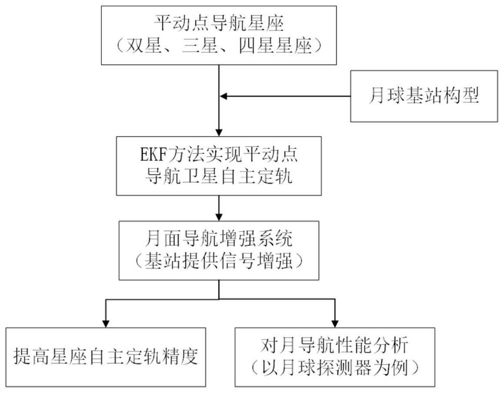
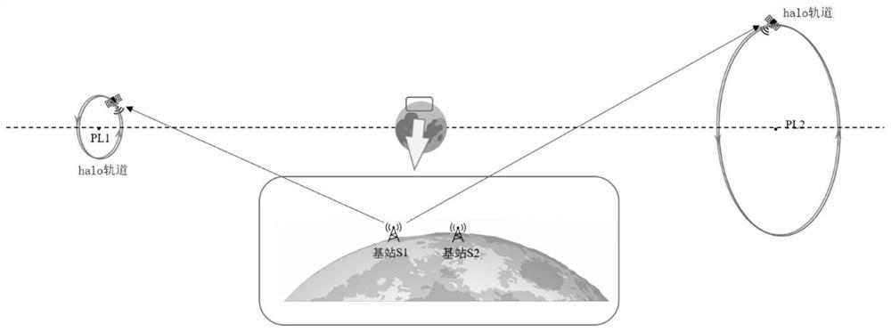
[0018] A base station is set up on the lunar surface, and several satellites are deployed in orbit around the translation point in the earth-moon space. The satellites in the translation point navigation constellation use the EKF method for autonomous orbit determination. Realize orbit calculation and prediction, and build dynamic model to realize the whole network orbit determination of satellite navigation system. According to the requirements of precise orbit determination in lunar exploration missions, while ensuring the accuracy of autonomous orbit determination of satellites in translation point orbits, the observation data of lunar base stations are introduced to form a satellite and base station-based lunar navigation enhancement network, which improves the accuracy of the entire navigation constellation. High-precision positioning of the lunar surface, e...


PUM


Abstract

The invention discloses a moon area navigation enhancement method based on a translation point navigation constellation, and belongs to the technical field of navigation. The navigation constellation is composed of different numbers of translation point navigation satellites, and partial or all orbits are selected from periodic orbits near L1, L2, L4 and L5 translation points to serve as orbits for the navigation constellation to operate. Different numbers of lunar surface base stations are added in the navigation constellation, the observation geometry of the constellation is improved in combination with a translational point satellite, a ranging signal is enhanced, the autonomous orbit determination precision of the whole navigation constellation is improved, and the problem that the positioning precision of the lunar surface base stations in an earth-moon convergence coordinate system is not high enough is solved. The main purpose of the invention is to provide a lunar surface regional high-precision navigation function. The invention aims to provide a high-precision positioning lunar surface base station, realize high-precision navigation of a lunar surface area based on the lunar surface base station, and provide a novel navigation service for functions of resource exploitation, lunar surface inspection and the like of future lunar surface moving objects.

Description

technical field [0001] The invention relates to a construction method of an earth-moon space navigation constellation, including the configuration design of a translation point navigation satellite and a lunar base station, and belongs to the technical field of navigation. Specifically, it relates to a method for enhancing the regional navigation of a moving object on the lunar surface based on a translation point navigation constellation. Background technique [0002] my country's lunar exploration project started late, but its overall capabilities have developed rapidly. In the next few decades, the establishment of a lunar space station and lunar exploration will be further completed. The translation point located in the Earth-Moon system, with its unique spatial position, can provide better and more accurate navigation and positioning services to the lunar surface, which will be of great help to the progress of future lunar exploration projects. Arranging navigation sat...

Claims


Application Information

Patent Timeline
IPC IPC(8): G01S19/27G01S19/39G01S19/45G01C21/24
CPCG01S19/27G01S19/393G01S19/396G01S19/45G01C21/24
Inventor 高有涛卞悦
Owner NANJING UNIV OF AERONAUTICS & ASTRONAUTICS
Learn More