Landslide monitoring and early warning system for structural hybrid rock area
A technology for monitoring and early warning and melange, applied in alarms, climate sustainability, instruments, etc., can solve the problems of complex deformation rules of rock mass, false alarm and early warning information release, lag, etc.
- Summary
- Abstract
- Description
- Claims
- Application Information
AI Technical Summary
Problems solved by technology
Method used
Image
Examples
Embodiment 1
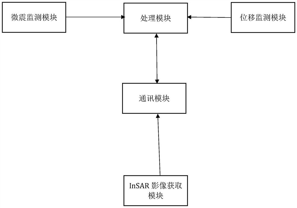
[0036] A landslide monitoring and early warning system (such as figure 1 shown), including:
[0037] The microseismic monitoring module is used to obtain the vibration amount generated by the rock mass rupture, and if the vibration amount exceeds the threshold, a first warning signal is generated;
[0038] InSAR image acquisition module (is a newly developed space-to-Earth observation technology, which is the product of the combination of traditional SAR remote sensing technology and radio astronomy interference technology. It uses radar to transmit microwaves to the target area, and then receives the echoes reflected by the target to get For the SAR complex image pairs imaged in the same target area, if there is a coherence condition between the complex image pairs, the interferogram can be obtained by conjugate multiplication of the SAR complex image pairs. According to the phase value of the interferogram, the path difference of the microwaves in the two imaging can be obta...
Embodiment 2
[0049] The difference between this embodiment and Embodiment 1 is that in this embodiment, the deformation of the InSAR image acquisition module exceeding the deformation threshold includes: dividing and connecting the monitoring points by equal deformation according to the deformation value of each monitoring point, Obtain a plurality of first isomorphic variable curves; calculate the distance between each monitoring point on each first isomorphic variable curve and the first isomorphic variable curve adjacent to the first isomorphic variable curve, so as to be less than the distance threshold The distance is the radius, and the monitoring point corresponding to the distance less than the distance threshold is used as the center of the circle to delineate the fission monitoring area. ; Compare the InSAR image at the i+3 moment with the InSAR image at the i+2 moment to determine the deformation value of each marked monitoring point; carry out an isomorphic calculation of the ma...
Embodiment 3
[0051] Compared with the second embodiment, the only difference is that the processing module is also used to, when the second early warning signal and the third early warning signal are received, and the first early warning signal is not received, take the current time as the first warning signal. The timestamp generates the first verification information; the communication module sends the first verification information to the adjacent communication module after receiving the first verification information; the communication module sends the first verification information to the processing module after receiving the first verification information, and the processing module receives the first verification information. After the first verification information, analyze the generation time of the first verification information, and compare it with the time when the second early warning signal and the third early warning signal are received, if the time is the same, an alarm signal...
PUM
 Abstract
Description
Claims
Application Information
 - R&D
- Intellectual Property
- Life Sciences
- Materials
- Tech Scout
- Unparalleled Data Quality
- Higher Quality Content
- 60% Fewer Hallucinations
Browse by: Latest US Patents, China's latest patents, Technical Efficacy Thesaurus, Application Domain, Technology Topic, Popular Technical Reports.
© 2025 PatSnap. All rights reserved.Legal|Privacy policy|Modern Slavery Act Transparency Statement|Sitemap|About US| Contact US: help@patsnap.com


