Parking space navigation method and device

A navigation method and technology for parking spaces, applied in the field of parking space navigation, can solve the problems of reducing the efficiency of parking lot circulation, difficult to search quickly and accurately, and reducing revenue, so as to improve the car experience and improve the efficiency of circulation.

Pending Publication Date: 2022-07-12
CHINA AUTOMOTIVE INNOVATION CORP
View PDF5 Cites 0 Cited by
  • Summary
  • Abstract
  • Description
  • Claims
  • Application Information

AI Technical Summary

Problems solved by technology

[0002] With the development of the times, more and more residents travel by car, and the scale of parking lots in various residential buildings, shopping malls, office buildings and other buildings is also expanding. There are thousands of parking spaces, and the layout is intricate and the signs are chaotic. It is often difficult to quickly find your own vehicle in the parking lot, which not only brings inconvenience to users, increases social costs, but also reduces the circulation efficiency of the parking lot and reduces revenue
[0003] In the prior art, by placing the GPS positioning device at the vehicle end, the information is transmitted to the GPS base station or the enhanced base station in the parking lot in real time. In addition, through the traditional navigation map drawing method, the tile or vector map of the parking lot is drawn in advance, and finally Car owners use the navigation route generated in the mobile app to find parking spaces. However, in general, the GPS signal in underground parking lots is weak, which will lead to inaccurate positioning. If the underground parking lot is multi-storey, it is difficult to pass between different floors of the multi-storey parking lot. The way of finding the way, and the construction of traditional navigation maps is relatively complicated and consumes a lot of cost; in the existing technology, the spatial modeling technology combined with the laser radar algorithm and the visual algorithm is used to restore the map data and save it as a high-precision map or Map data in other formats can finally realize the navigation and car search service, but the algorithm development in this technical solution is more complicated, and in the process of drawing, it cannot be guaranteed that all parking spaces are empty, which affects the accuracy of drawing
[0004] Therefore, there is a need for an improved technical solution for parking space navigation to solve the problems of low navigation accuracy and difficulty in finding vehicles quickly and accurately between different floors of multi-storey parking lots in the prior art

Method used


Image

  • Parking space navigation method and device
  • Parking space navigation method and device
  • Parking space navigation method and device

Examples


Embodiment Construction

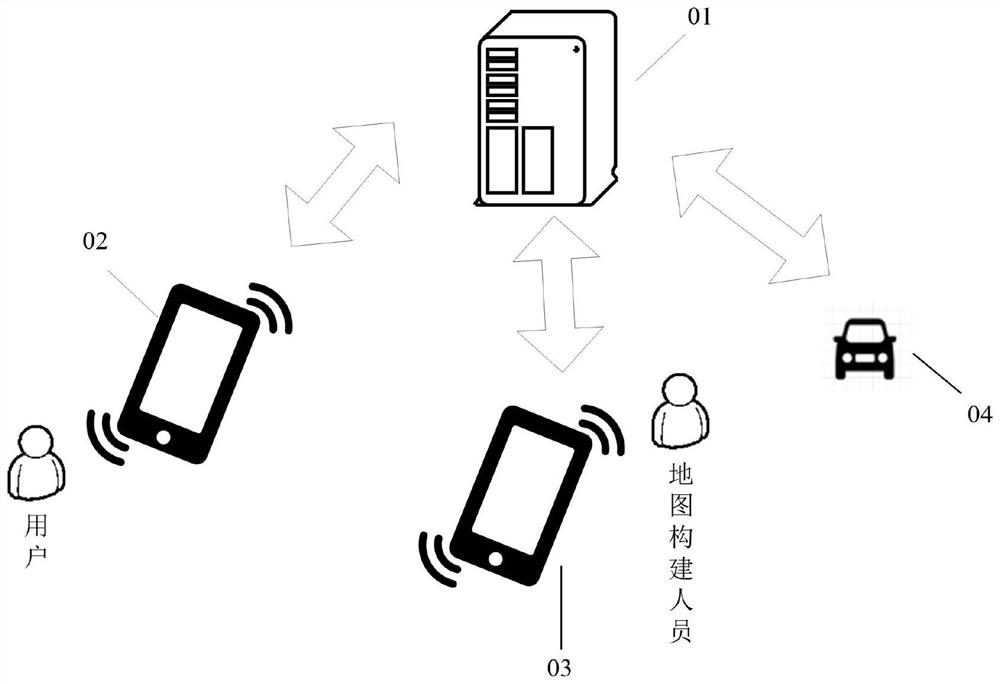
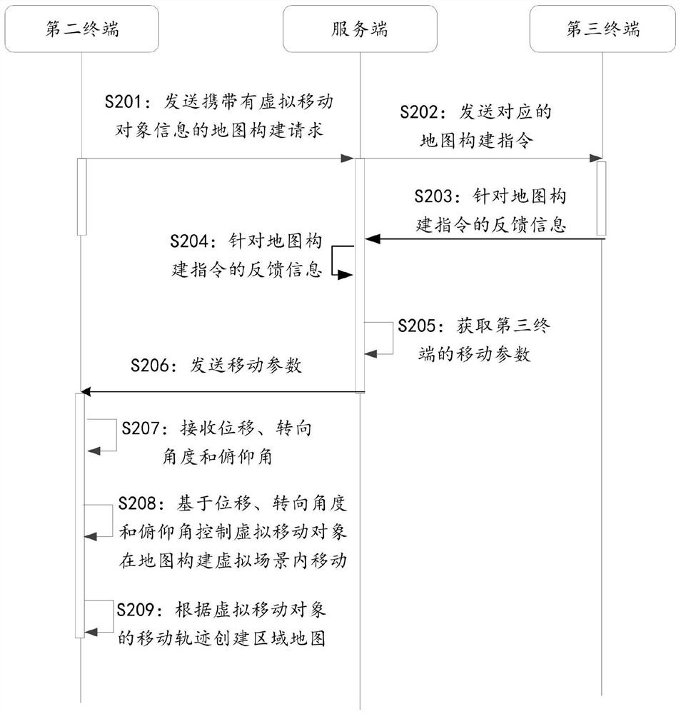
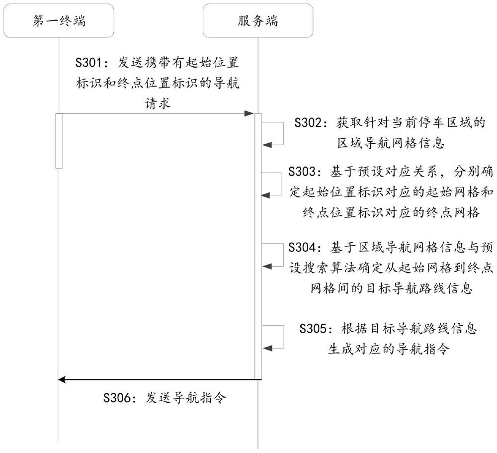
[0047] The technical solutions in the embodiments of the present application will be clearly and completely described below with reference to the drawings in the embodiments of the present application. Obviously, the described embodiments are only a part of the embodiments of the present application, but not all of the embodiments. Based on the embodiments in the present application, all other embodiments obtained by those of ordinary skill in the art without creative work shall fall within the protection scope of the present application.

[0048] It should be noted that the terms "first", "second", etc. in the description and claims of the present application and the above drawings are used to distinguish similar objects, and are not necessarily used to describe a specific sequence or sequence. It is to be understood that data so used may be interchanged under appropriate circumstances such that the embodiments of the application described herein can be practiced in sequences ...


PUM


Abstract

The invention discloses a parking space navigation method and device, and the method comprises the steps: responding to a map construction request which is transmitted by a second terminal and carries virtual moving object information, and transmitting a corresponding map construction instruction to a third terminal; establishing an association relationship between the virtual moving object and the third terminal based on feedback information of the third terminal for the map construction instruction; acquiring movement parameters of a third terminal, wherein the movement parameters comprise displacement, a steering angle and a pitch angle; and sending the movement parameter to the second terminal, so that the second terminal controls the virtual moving object to move in the map construction virtual scene based on the displacement, the steering angle and the pitch angle, and creates a regional map according to the movement track of the virtual moving object to obtain a regional navigation map. The regional navigation map constructed by using the technical scheme provided by the invention can quickly and accurately help the vehicle owner to find the vehicle, so that the circulation efficiency of the vehicle in the parking lot is improved, and the vehicle use experience of the vehicle owner is improved.

Description

technical field [0001] The present application relates to the technical field of parking space navigation of traffic control systems, and in particular, to a parking space navigation method and device. Background technique [0002] With the development of the times, more and more residents travel by car, and the scale of parking lots of various residential buildings, shopping malls, office buildings and other buildings is also expanding. It is often difficult to quickly find one's own vehicle in the parking lot, which not only brings inconvenience to users, but also increases social costs, reduces the circulation efficiency of the parking lot, and reduces revenue. [0003] In the prior art, by placing the vehicle-end GPS positioning device, information is transmitted to the GPS base station or the enhanced base station in the parking lot in real time, and the tile or vector map of the parking lot is drawn in advance through the traditional navigation map drawing method, and ...

Claims


Application Information

Patent Timeline
Patent Type & Authority Applications(China)
IPC IPC(8): G08G1/0969G08G1/0968G08G1/14G01C21/00
CPCG08G1/0969G08G1/096805G08G1/141G01C21/3804
Inventor 李丰军周剑光白启扉
Owner CHINA AUTOMOTIVE INNOVATION CORP
Why Eureka
Try Eureka