Positioning and mapping method and device and electronic equipment

A technology in images and images, which is applied in the field of big data analysis, can solve problems such as splicing dislocation and deformation, and achieve the effect of reducing splicing errors and improving map splicing effects

Active Publication Date: 2022-07-15
镁佳(北京)科技有限公司
View PDF7 Cites 2 Cited by
  • Summary
  • Abstract
  • Description
  • Claims
  • Application Information

AI Technical Summary

Problems solved by technology

[0004] Therefore, the technical problem to be solved by the present invention is to overcome the defects of splicing dislocation and deformation in the existing 360 surround view, thereby providing a positioning and mapping method, device and Electronic equipment

Method used


Image

  • Positioning and mapping method and device and electronic equipment
  • Positioning and mapping method and device and electronic equipment
  • Positioning and mapping method and device and electronic equipment

Examples


Embodiment Construction

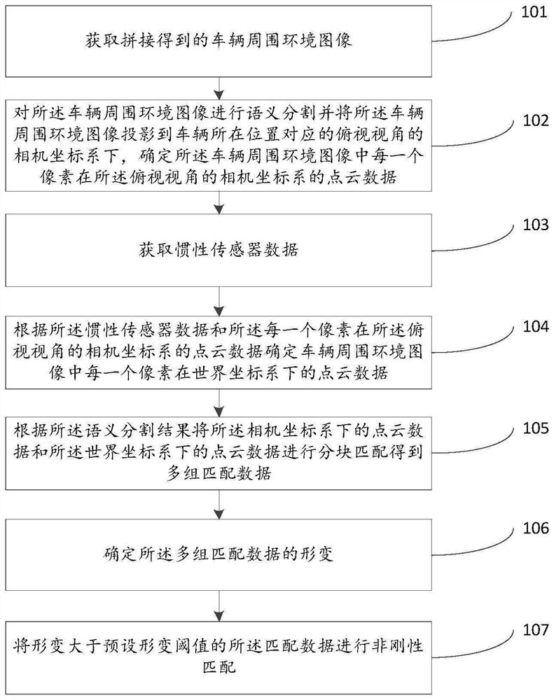
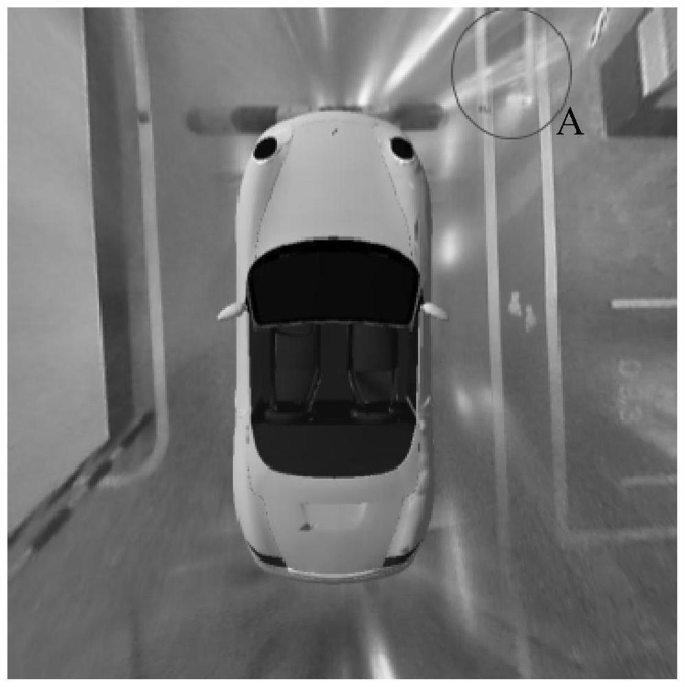
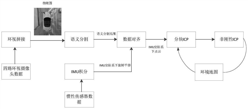
[0025] The technical solutions of the present invention will be clearly and completely described below with reference to the accompanying drawings. Obviously, the described embodiments are a part of the embodiments of the present invention, but not all of the embodiments. Based on the embodiments of the present invention, all other embodiments obtained by those of ordinary skill in the art without creative efforts shall fall within the protection scope of the present invention.

[0026] In the description of the present invention, it should be noted that the terms "center", "upper", "lower", "left", "right", "vertical", "horizontal", "inner", "outer", etc. The indicated orientation or positional relationship is based on the orientation or positional relationship shown in the accompanying drawings, and is only for the convenience of describing the present invention and simplifying the description, rather than indicating or implying that the indicated device or element must have ...


PUM


Abstract

The invention discloses a positioning and mapping method and apparatus, and an electronic device. The method comprises the steps of obtaining a spliced vehicle surrounding environment image; semantic segmentation is carried out on the vehicle surrounding environment image, the vehicle surrounding environment image is projected to a camera coordinate system of a top view angle corresponding to the position of the vehicle, and point cloud data of each pixel in the vehicle surrounding environment image in the camera coordinate system of the top view angle is determined; acquiring inertial sensor data; determining point cloud data of each pixel in a world coordinate system in the vehicle surrounding environment image according to the inertial sensor data and the point cloud data of each pixel in the camera coordinate system of the overlooking view angle; performing block matching on the point cloud data under the camera coordinate system and the point cloud data under the world coordinate system according to a semantic segmentation result to obtain multiple groups of matched data; determining deformation of the multiple groups of matched data; and performing non-rigid matching on the matching data of which the deformation is greater than a preset deformation threshold value.

Description

technical field [0001] The invention relates to the technical field of big data analysis, in particular to a positioning and mapping method, device and electronic equipment. Background technique [0002] The 360 ​​surround view system has gradually become a standard on the car. After splicing multiple fisheye cameras around the car body, a large picture reflecting the surrounding environment of the car body is formed, and semantic segmentation is performed on the picture (the lane lines are segmented at the pixel level. , roadblocks, parking space lines, etc.), combined with the data information of sensors such as IMU, the parking lot environment can be mapped and the vehicle position can be obtained in real time. However, due to the inaccurate calibration of the fisheye camera by the mass-produced vehicle and the loosening of the camera position, the stitched overhead images will be dislocated and deformed, and the information in the environment cannot be truly reflected. ...

Claims


Application Information

Patent Timeline
Patent Type & Authority Applications(China)
IPC IPC(8): G01C21/28G01C21/32G01C21/16G01C21/00G06V20/56G06T7/73G06V10/26
CPCG01C21/28G01C21/32G01C21/1656G01C21/3841G01C21/3859G06T7/73G06T2200/32G06T2207/10028G06T2207/20021
Inventor 刘震
Owner 镁佳(北京)科技有限公司
Why Eureka
Try Eureka