Intelligent early warning and path planning traffic system based on AI and GIS

A route planning and traffic system technology, applied in traffic flow detection, alarm, road network navigator, etc., can solve the problems of lack of information interaction of road management departments, unhealthy road surface, and affecting planning effects, etc., to improve road management efficiency and service level effect

Pending Publication Date: 2022-07-22
ANHUI FUHUANG TECH CO LTD
View PDF18 Cites 0 Cited by
  • Summary
  • Abstract
  • Description
  • Claims
  • Application Information

AI Technical Summary

Problems solved by technology

[0004] 1) In the process of planning the route, there is a lack of real-time detection of the road surface, which makes the road surface unhealthy on the planned route, which affects the riding experience and driving experience;
[0005] 2) In the process of planning the route, there is a lack of correction of the route and avoidance of congested roads, which affects the planning effect;
[0006] 3) In the process of planning the route, there is a lack of information interaction with the road management department, and the function is too single

Method used


Image

  • Intelligent early warning and path planning traffic system based on AI and GIS
  • Intelligent early warning and path planning traffic system based on AI and GIS
  • Intelligent early warning and path planning traffic system based on AI and GIS

Examples


Embodiment

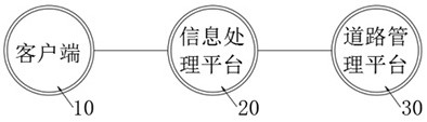
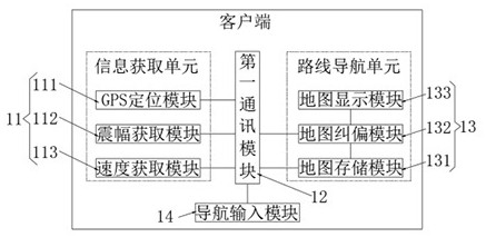
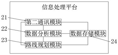
[0051] like Figure 1-4 As shown, the present invention provides a smart early warning and route planning traffic system based on AI and GIS, including a client 10, an information processing platform 20 and a road management platform 30, wherein: the client 10 includes an information acquisition unit 11, a first communication module 12 and the route navigation unit 13, the information acquisition unit 11 is used to acquire the GPS information of the vehicle, the vibration amplitude information of the vehicle, the vehicle speed information and the congestion degree information, and the first communication module 12 is used to realize the client 10 and the information processing platform 20. The route navigation unit 13 is used to provide offline vehicle navigation and vehicle navigation map deviation correction, the first communication module 12 is connected to the information acquisition unit 11 and the route navigation unit 13; the information processing platform 20 is used to...


PUM


Abstract

The invention relates to the technical field of public transportation, in particular to an intelligent early warning and path planning traffic system based on AI and GIS. Comprising a client, an information processing platform and a road management platform. According to the invention, GIS map correction, off-line positioning, road surface health condition calculation based on vibration amplitude and road section calculation based on GPS points are combined for use, so that business management technical services such as road construction, management and maintenance are provided for a road competent department, and work such as digital management, construction supervision and maintenance implementation of road infrastructures is effectively carried out; cooperative management and linkage operation of road planning, construction and maintenance are realized, and the road management efficiency and service level are improved.

Description

technical field [0001] The invention relates to the technical field of public transport, in particular to a smart early warning and route planning traffic system based on AI and GIS. Background technique [0002] With the development of urbanization and motorization, the urban population and area continue to increase, and the demand for public transportation is correspondingly increasing rapidly. Public transportation companies are required to invest more passenger cars, and management departments are also required to improve their management effects to achieve public transportation. manage. [0003] The patent application number is CN201110172619.7, and the patent name is "Navigation system and its path planning method", which is recorded in the description "comprising a storage unit and a processing unit. The storage unit is provided with a cloud database of a cloud server and a navigation system. A local database of the system, in order to store a road condition data.The...

Claims


Application Information

Patent Timeline
Patent Type & Authority Applications(China)
IPC IPC(8): G08G1/01G08B25/08G08B31/00G01C21/34
CPCG08G1/0125G08G1/0137G08B31/00G08B25/08G01C21/3461
Inventor 刘磊任子晖王卫罗晶晶高洪昌倪金林王晓娟姚翔蒋梦媛黄兴亮
Owner ANHUI FUHUANG TECH CO LTD
Why Eureka
Try Eureka