Soil humidity estimation method and equipment based on Beidou navigation data of smart phone

A smart phone and soil moisture technology, applied in the field of remote sensing, can solve the problems of large dispersion, large detection range, and high flight altitude of remote sensing satellites, and achieve the effect of easy calculation and strong generalization

Pending Publication Date: 2022-08-09
WUHAN UNIV
View PDF0 Cites 0 Cited by
  • Summary
  • Abstract
  • Description
  • Claims
  • Application Information

AI Technical Summary

Problems solved by technology

The relevant soil moisture measurement method is generally a small-scale humidity at a point, and the contact measurement workload is high, the cost is high, and the degree of dispersion is large, which cannot reflect the soil moisture characteristics of an entire area; the remote sensing satellite

Method used


Image

  • Soil humidity estimation method and equipment based on Beidou navigation data of smart phone
  • Soil humidity estimation method and equipment based on Beidou navigation data of smart phone
  • Soil humidity estimation method and equipment based on Beidou navigation data of smart phone

Examples


Example Embodiment

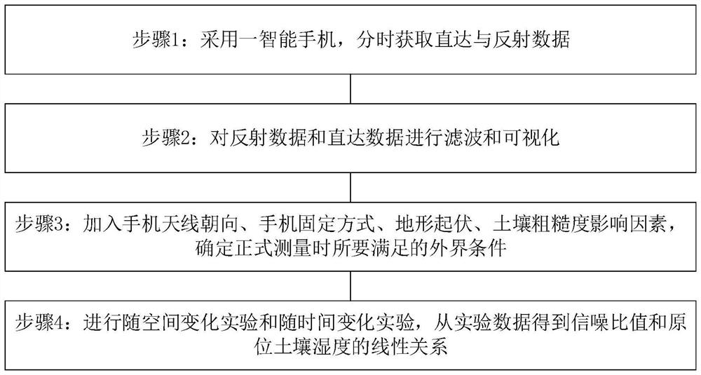
[0026] In order to make the purposes, technical solutions and advantages of the embodiments of the present invention clearer, the technical solutions in the embodiments of the present invention will be clearly and completely described below with reference to the accompanying drawings in the embodiments of the present invention. Obviously, the described embodiments These are some embodiments of the present invention, but not all embodiments. Based on the embodiments of the present invention, all other embodiments obtained by those of ordinary skill in the art without creative efforts shall fall within the protection scope of the present invention. In addition, the technical features in each embodiment or a single embodiment provided by the present invention can be arbitrarily combined with each other to form a feasible technical solution. This combination is not restricted by the sequence of steps and / or the structural composition mode, but must be in the order of Those of ordi...


PUM


Abstract

The invention provides a soil humidity estimation method and equipment based on Beidou navigation data of a smart phone. The method comprises the following steps of: 1, acquiring direct and reflection data in a time-sharing manner by adopting a smart phone; 2, filtering and visualizing the reflection data and the direct data; 3, adding influence factors such as mobile phone antenna orientation, mobile phone fixing mode, topographic relief and soil roughness, and determining external conditions to be met during formal measurement; and step 4, carrying out an experiment changing along with space and an experiment changing along with time, and obtaining a linear relation between the signal-to-noise ratio and the in-situ soil humidity from experimental data. According to the method, the soil humidity is estimated by trying to use the signal-to-noise ratio of the Beidou signal of the smart phone for the first time, compared with a traditional fixed receiver, an experiment area can be flexibly selected, real-time data can be acquired on site, the Beidou GEO satellite is static relative to the ground, the position of a reflection area is fixed and easy to calculate, and generalization in daily life is high.

Description

technical field [0001] Embodiments of the present invention relate to the field of remote sensing technology, and in particular, to a method and device for estimating soil moisture based on smart phone Beidou navigation data. Background technique [0002] Soil moisture is soil water content, which is an important physical substance of soil. Accurate, timely and long-term tracking and monitoring of soil moisture is very important for agricultural, hydrological, meteorological, and geophysical research. The relevant soil moisture measurement method is generally a small range of humidity at a point. The contact measurement has a large workload and high cost, and has a large degree of dispersion, which cannot reflect the soil moisture characteristics of an entire area. The remote sensing satellite has a high flying height and can detect The range is very large, the components in the soil covered are diverse and complex, and the measured results are usually average values. It is ...

Claims


Application Information

Patent Timeline
IPC IPC(8): G01N22/04G01S19/37
CPCG01N22/04G01S19/37
Inventor 严颂华殷杏亭胡军蒋坤呈
Owner WUHAN UNIV
Why Eureka
Try Eureka