GPS satellite time service telemetering seismograph

A satellite timing and seismometer technology, which is applied in coalfield, geology, engineering exploration, and petroleum fields, can solve problems such as the inability to meet the development needs of new geophysical technologies and new methods, and the difficulty of implementing instruments, so as to reduce exploration costs, reduce weight and volume effect

Inactive Publication Date: 2003-05-14
BC P INC CHINA NAT PETROLEUM CORP +1
View PDF0 Cites 43 Cited by
  • Summary
  • Abstract
  • Description
  • Claims
  • Application Information

AI Technical Summary

Problems solved by technology

[0007] 2. Insufficiency of today's telemetry seismic instruments
[0014] It cannot meet the development needs of new geophysical technologies and methods; at present, all seismic instruments in the world except the RSR S...

Method used


Image

  • GPS satellite time service telemetering seismograph
  • GPS satellite time service telemetering seismograph
  • GPS satellite time service telemetering seismograph

Examples


Embodiment Construction

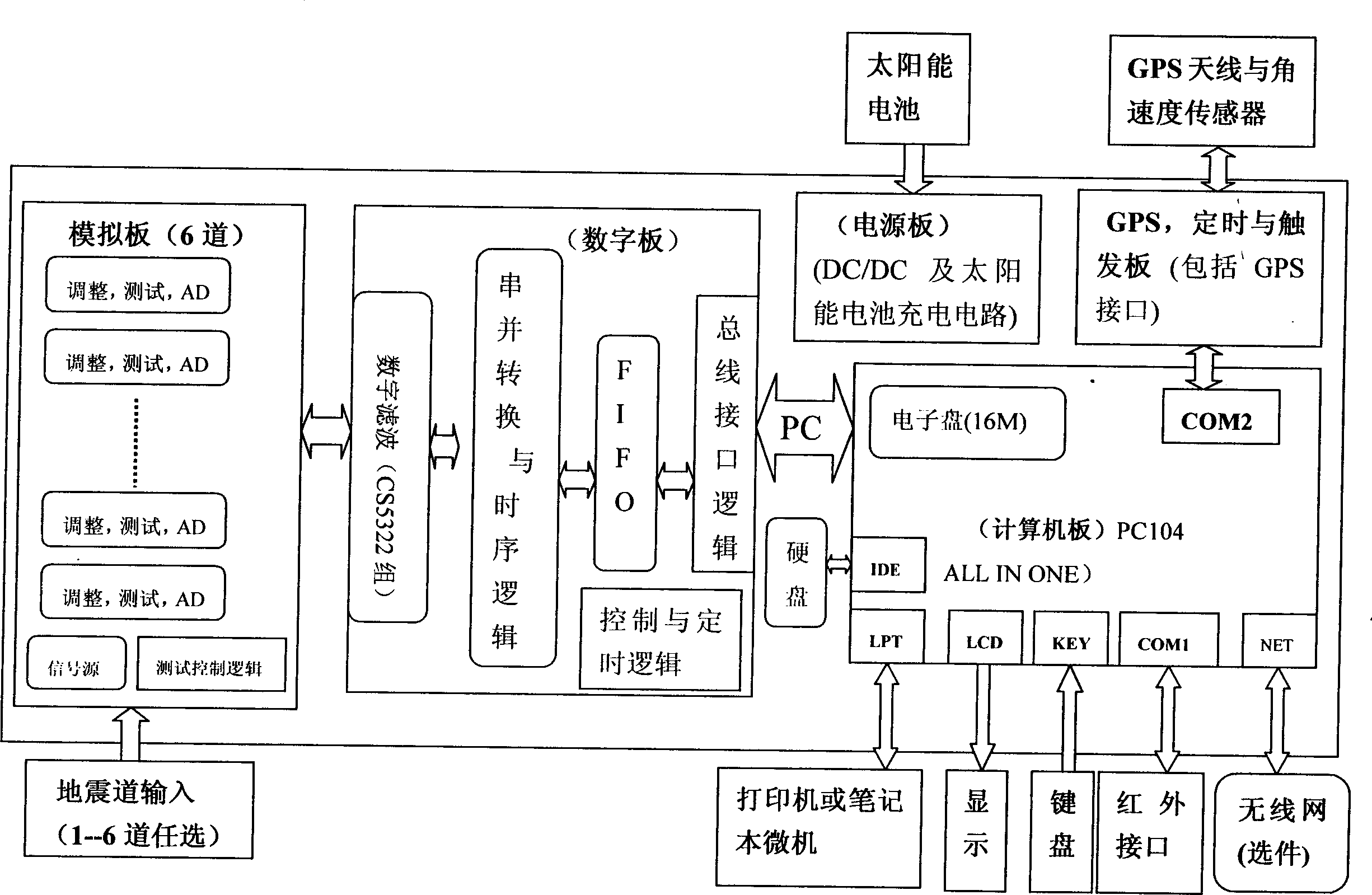
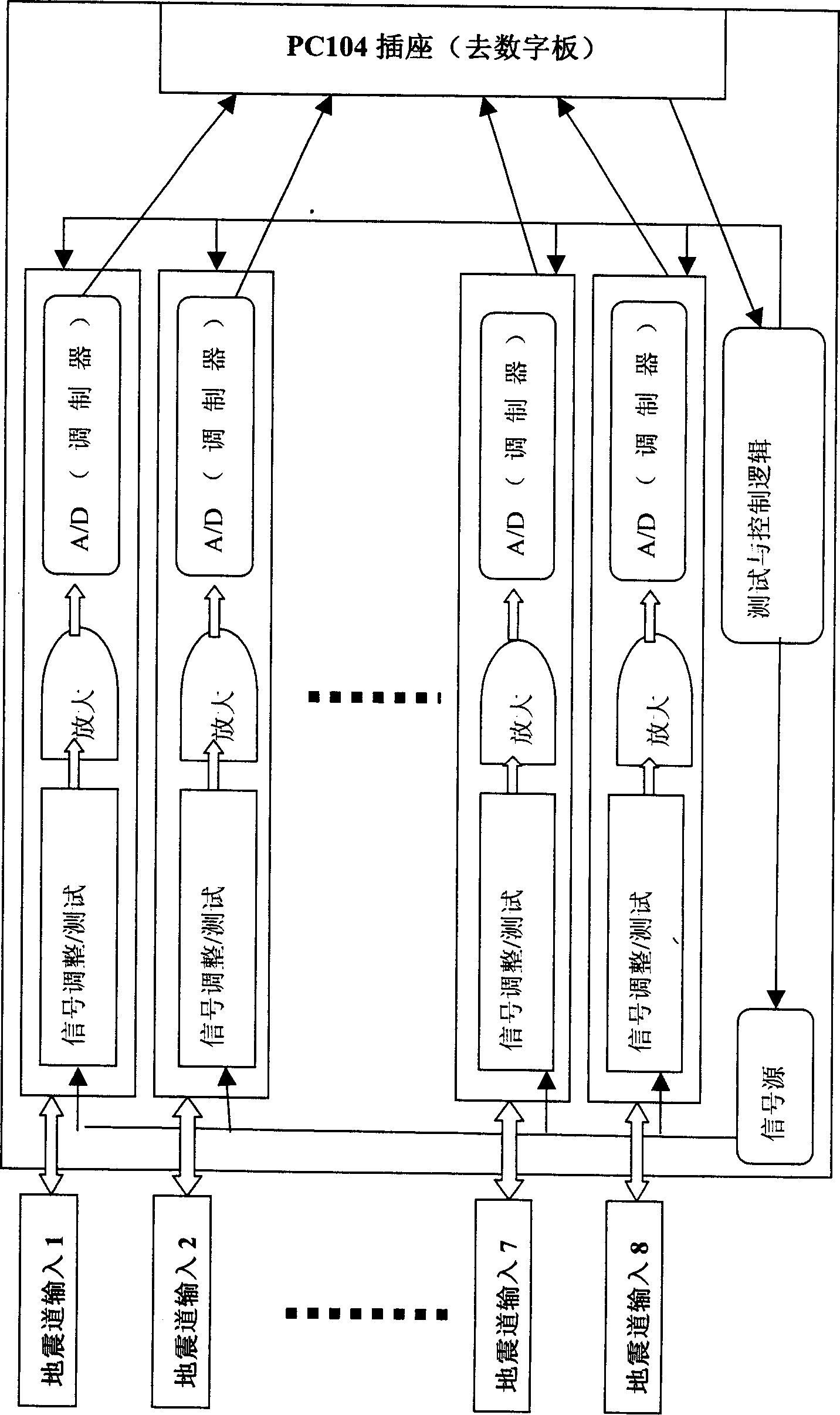
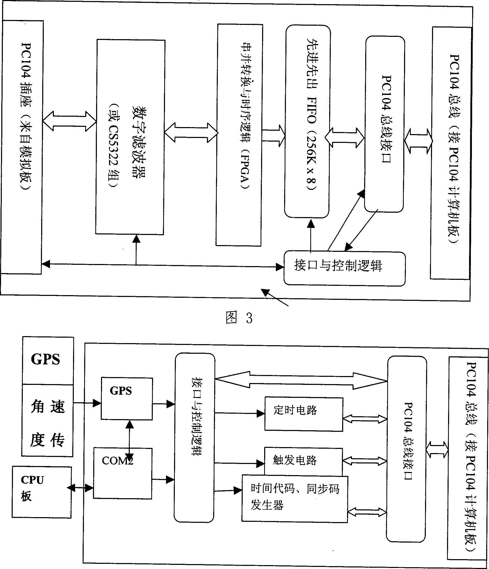
[0041] The design concept of the high-precision timing seismic instrument (referred to as the timing seismic instrument) is to realize the real unattended and fully automatic functions. Develop a new type of telemetry seismograph that is the lightest, most flexible in construction, easiest in operation, highly stable and reliable, truly intelligent, has unlimited channel expansion functions, and can be placed freely. Complex terrain (such as mountains, jungles, swamps, water networks, intertidal zones) and complex construction method exploration needs. It can continuously collect and record all climates. The hardware system structure is only composed of two parts: the acquisition recording and processing unit (DCPU) and the timing start firing unit (BLU). It completely changes the structure of traditional seismic exploration instruments, removes the central control unit, and is designed to integrate the acquisition part and the recording part (single station with 6 channels, ...


PUM


Abstract

A GPS satellite time service telemetering seismograph is used in natural seismic measurements; synchronous data measurement and record; and synchronous timing detonation, and consists of two parts including data collecting and processing unit and timing start and blowing unit. The present invention can realize unattended and fully automatic functions and may be used to meet the requirement of exploration in complex area and for complex construction method. It has completely new seismograph structure without host computer, master cable and communication station.

Description

technical field [0001] The invention relates to the fields of petroleum, geology, coal field and engineering exploration, in particular, it is a GPS satellite timing telemetry seismograph used for natural earthquake measurement, synchronous data measurement and recording, and synchronous timing detonation. Background technique [0002] 1. Status quo of telemetry seismic exploration instruments [0003] In geophysical seismic exploration, elastic waves are generated artificially and propagated to underground strata. When encountering stratum interfaces with different wave impedances, the elastic waves are reflected and refracted. The data of elastic waves are measured, received and recorded by instruments on the ground, and analyzed and processed by computer to infer the underground geological structure. Geophysical telemetry seismic instrument is a very important part of seismic exploration. It refers to a set of system equipment used for seismic exploration data acquisitio...

Claims


Application Information

Patent Timeline
IPC IPC(8): G01V1/00G01V1/04G01V1/24G01V1/28
Inventor 李庆忠陈联青夏祥瑞罗维炳易碧金党晓春罗福龙
Owner BC P INC CHINA NAT PETROLEUM CORP
Why Eureka
Try Eureka