System and method for reference data processing in network assisted position determination

a reference data and network assisted technology, applied in the field of position determination, can solve the problems of long processing time, time-consuming multiplicity of satellites, and inability to search for and acquire gps signals,

Active Publication Date: 2003-11-13
QUALCOMM INC
View PDF9 Cites 37 Cited by
  • Summary
  • Abstract
  • Description
  • Claims
  • Application Information

AI Technical Summary

Problems solved by technology

The process of searching for and acquiring GPS signals, reading the ephemeris and GPS system data (ionospheric data, universal time coordinated (UTC) data, almanac data, health data) for a multiplicity of satellites is time consuming.
In many cases, this lengthy processing time is unacceptable and, furthermore, greatly limits battery life in micro-miniaturized portable applications.
Another limitation of current GPS receivers is that successful operation is limited to situations in which multiple satellites are clearly in view, i.e., without obstructions, and a good quality antenna is properly positioned to receive such signals.
As such, current GPS receivers normall

Method used


Image

  • System and method for reference data processing in network assisted position determination
  • System and method for reference data processing in network assisted position determination
  • System and method for reference data processing in network assisted position determination

Examples


Embodiment Construction

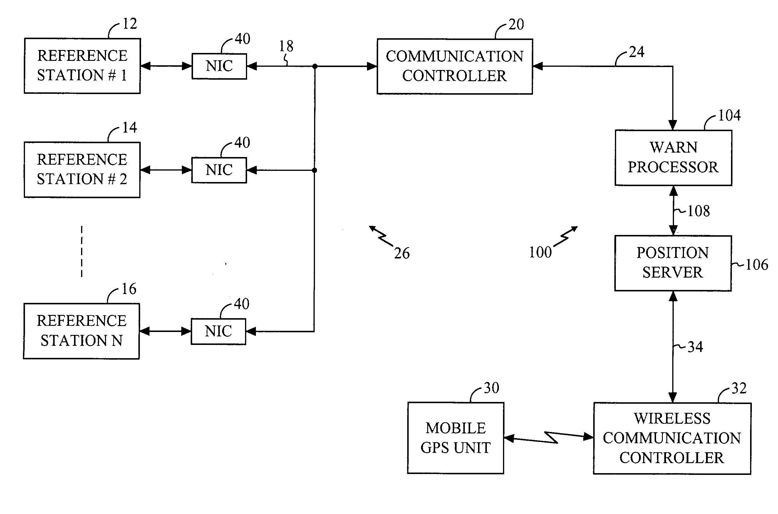
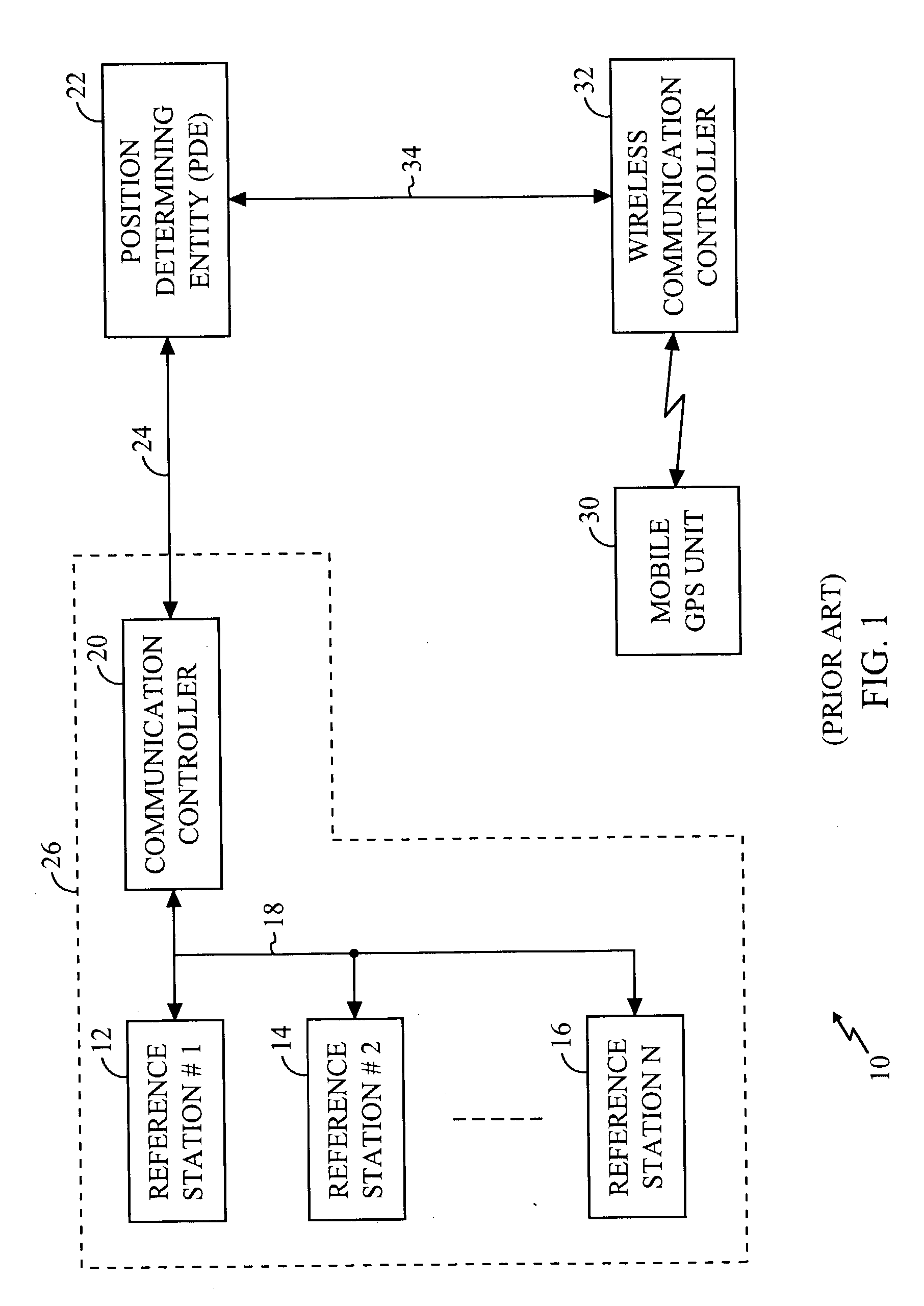
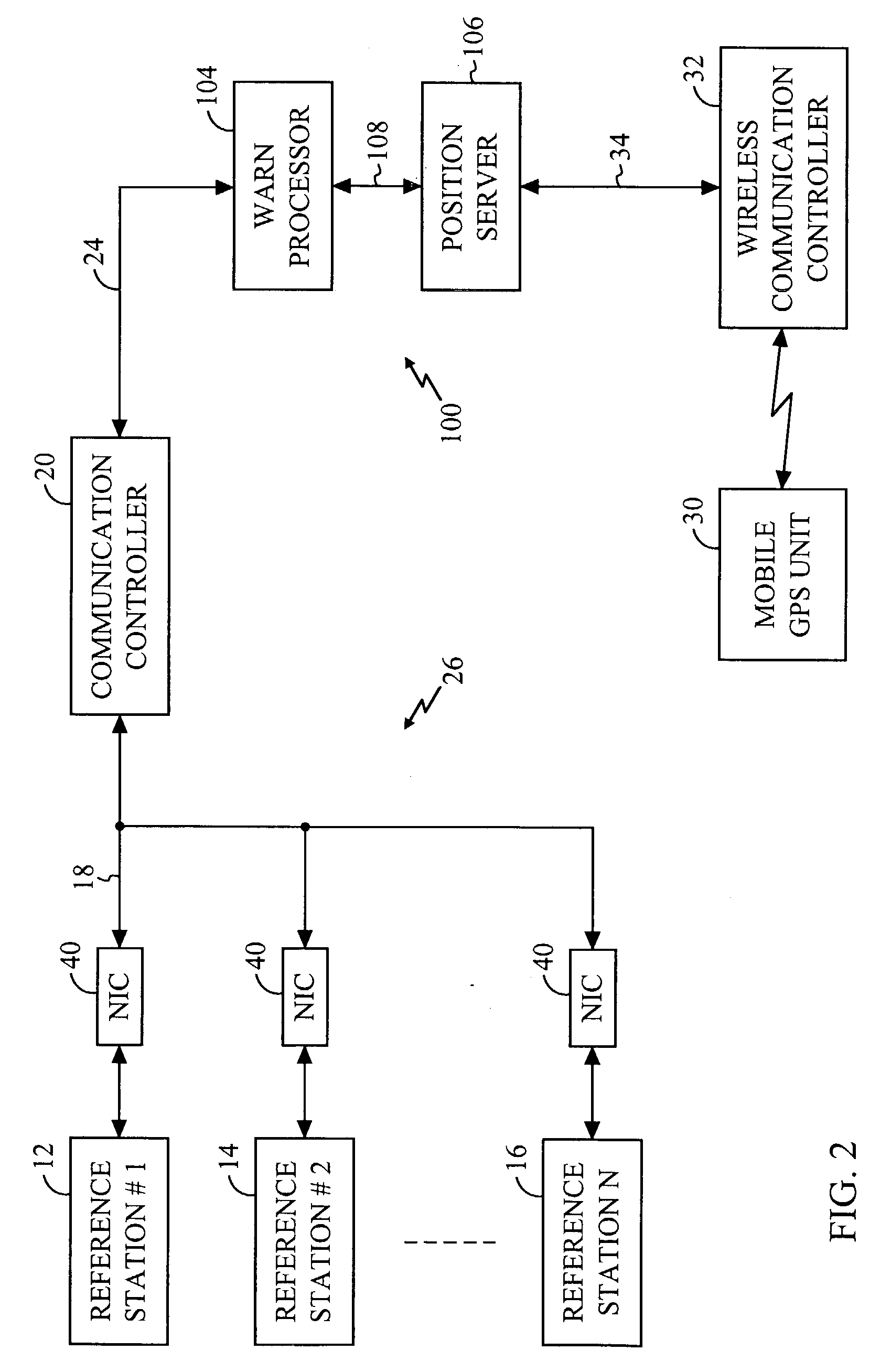
[0029] In conventional systems, the Position Determination Entity (PDE) 22 must process a significant amount of reference data from the Wide Area Reference Network (WARN) 26 to determine the location of the mobile Global Positioning System (GPS) unit 30. The present techniques include a preprocessor that analyzes data from the WARN 26 prior to processing by the PDE 22. As a result of this preprocessing, the workload of the PDE 22 is greatly reduced and the throughput of the position determining technology thereby enhanced.

[0030] One system 100 is shown in a simplified form in the functional block diagram of FIG. 2. A plurality of reference stations (e.g., the reference stations 12-16) each generate a set of reference data for transmission to a Communication Controller (CC) (e.g., the communication controller 20) via a communication link 18. For the sake of convenience in describing the system 100, the communication link 18 will be described herein as a wide area network (WAN). Howev...


PUM


Abstract

A system and method of preprocessing reference data in a reference assisted location technology are disclosed. A plurality of reference stations each provides reference data over a network to a preprocessing. The preprocessor analyzes the data from the multiple reference stations and eliminates multiples sets of redundant data. In addition, the preprocessor can perform quality assurance checks on the data as well as the status of the reference stations themselves. Non-redundant data may also be preprocessed to perform differential GPS calculations. The preprocessed data is transmitted to one or more position servers for additional processing and position determination.

Description

[0001] This application claims priority to U.S. Provisional Application No. 60 / 380,405, filed on May 13, 2002.[0002] 1. Technical Field[0003] The present invention relates generally to position determination and, in particular, concerns server-assisted position determination technology.[0004] 2. Description of the Related Art[0005] Satellite position systems (SPS) determine the location of a receiver based on signals received from a plurality of satellites. In one example of an SPS, known as a Global Positioning System (GPS), receivers normally determine their position by computing relative times of arrival of signals transmitted simultaneously from a multiplicity of GPS satellites. These satellites transmit, as part of their message, both satellite positioning data as well as data on clock timing, so-called "ephemeris" data. The process of searching for and acquiring GPS signals, reading the ephemeris and GPS system data (ionospheric data, universal time coordinated (UTC) data, alm...

Claims


Application Information

Patent Timeline
IPC IPC(8): G01S19/05G01S1/00G01S5/00G01S19/11G01S19/21G01S19/29G01S19/46
CPCG01S5/009G01S19/07G01S19/05G01S19/071
Inventor BIACS, ZOLTANMOEGLEIN, MARKMCGLOIN, JUSTIN
Owner QUALCOMM INC
Why Eureka
Try Eureka