Time acquisition in a wireless position determination system

a position determination and time acquisition technology, applied in the field of position determination systems, can solve the problems of inconvenient use, inability to search, and inability to accurately identify the position of the receiver, etc., and achieve the effect of improving the accuracy and efficiency of other known approaches, and reducing the cost of us

Inactive Publication Date: 2005-01-06
YOUNIS SAED
View PDF14 Cites 53 Cited by
  • Summary
  • Abstract
  • Description
  • Claims
  • Application Information

AI Technical Summary

Problems solved by technology

An exhaustive search across the entire range of potential carrier frequencies for each of the 24 PN codes can be undesirably time consuming—in many cases taking minutes.
Although the use of almanac data can reduce the search time, the use of almanac data lacks the precision and efficiency of other known approaches.
The real-time information compiled by the PDE is typically more precise than standard almanac data and often results in a shorter GPS signal acquisition time.
In many wireless communications networks, however, such as asynchronous wideband code division multiple access (WCDMA) networks and Global System for Mobile Communications (GSM) networks, the internal clocks of the mobile devices are not necessarily synchronized with the base stations, PDEs and stationary GPS receivers.
Consequently, a mobile device cannot rely on information that describes the time at which a stationary GPS receiver expects to receive the beginning of each PN frame.
Transmitting such GPS timing information to the mobile device would provide little benefit in terms of reducing the GPS signal acquisition time.

Method used


Image

  • Time acquisition in a wireless position determination system
  • Time acquisition in a wireless position determination system
  • Time acquisition in a wireless position determination system

Examples


Embodiment Construction

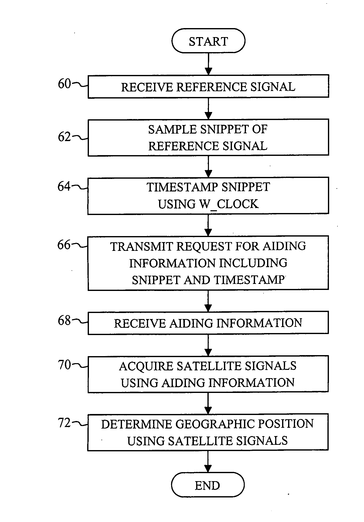
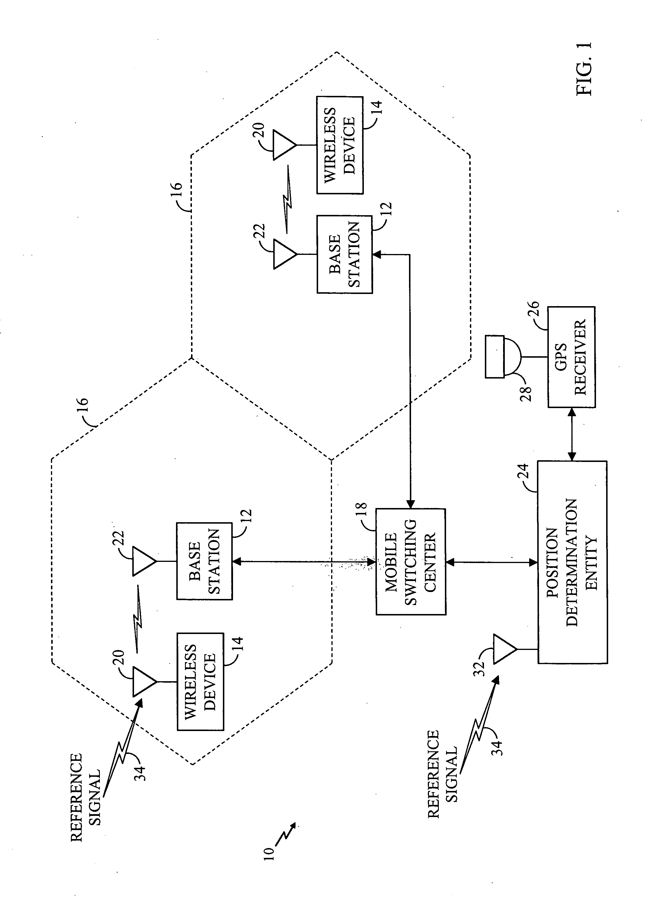
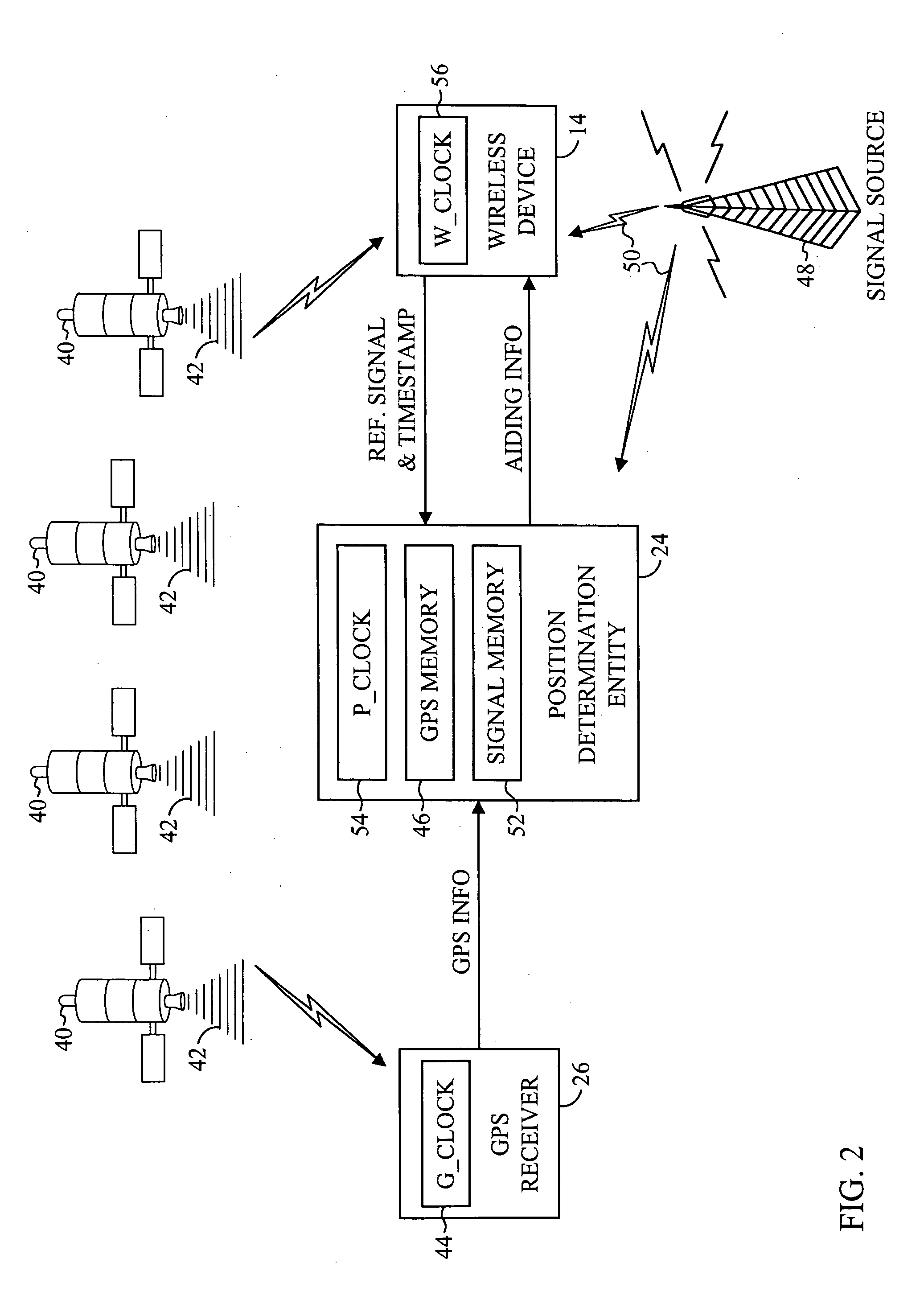
[0027] The present invention is an improved system and method for providing timing information to a mobile device in a position determination system. FIG. 1 illustrates a wireless communications system 10 in accordance with a preferred embodiment of the present invention. The wireless communications system 10 is a cell-based communications system including a plurality of base stations 12 and a plurality of wireless devices 14. Each base station 12 has an associated cell 16 defining a geographical coverage area serviced by the base station 12. Each wireless device 14 positioned within one of the cells 16 is adapted to communicate with the associated base station 12 by exchanging data packets according to a predetermined communications protocol, such as wideband code division multiple access (WCDMA). The wireless devices 14 may be any devices that are adapted to communicate with the base stations 12 over a wireless communications link, including mobile telephones, personal digital ass...


PUM


Abstract

A system and method for providing timing information to a wireless device in a position determination system is disclosed. A wireless device includes a reference signal receiver, a signal processor, a wireless communications transceiver and a GPS receiver. The wireless device is adapted to receive a reference signal, extract a snippet of the received reference signal, determine a time of reception for the snippet and transmit the snippet and time of reception to a position determination entity as part of a request for GPS aiding information. The position determination entity includes a timing source, a GPS memory for storing GPS satellite information, a reference signal memory, a communications interface, a signal processor and a control processor. The position determination entity is adapted to continually receive and store a reference signal along with an associated time of reception, and receive the snippet and timestamp transmitted from the wireless device. The position determination entity is further adapted to match the signal snippet to a portion of the stored reference signal, determine a time offset between the timestamp and the time of reception of the matched portion of the stored reference signal, prepare aiding information for the wireless device, synchronize the aiding information to the wireless device using the time offset, and transmit the synchronized aiding information to the wireless device. The wireless device is further adapted to receive the aiding information, including timing information to assist the wireless device in acquiring the GPS signals.

Description

RELATED APPLICATIONS [0001] This application is a continuation of U.S. patent application Ser. No. 10 / 099,096, filed on Mar. 15, 2002, which claims priority to U.S. Provisional Application No. 60 / 276,722, filed on Mar. 15, 2001.BACKGROUND OF THE INVENTION [0002] 1. Field of the Invention [0003] The present invention relates generally to position determination systems and, in particular, to providing timing information to a wireless device in a position determination system. [0004] 2. Description of the Related Art [0005] Systems for determining the geographic position of a wireless device are well known in the art. A commonly used position determination system is the Global Positioning System (GPS) operated by the United States Department of Defense. The GPS includes a network of 24 satellites that orbit the earth in six circular planes. The GPS satellites are spaced so that, at any given time and from any geographic position, at least five GPS satellites will be above the horizon. ...

Claims


Application Information

Patent Timeline
Patent Type & Authority Applications(United States)
IPC IPC(8): G01S19/25G01S1/00G01S19/05G01S19/13G01S19/37H04W56/00H04W64/00
CPCG01S19/256G01S19/05G01S19/37G01S19/13
Inventor YOUNIS, SAED
Owner YOUNIS SAED
Why Eureka
Try Eureka