Three dimensional tangible interface for interacting with spatial-temporal data using a laser scanner

a laser scanner and spatial-temporal data technology, applied in the field of systems for interacting with spatial data, can solve the problems of difficult to combine the benefits of physical and digital models in the same representation, relatively little development of the interface through which landscape based information is presented and manipulated, and large number of people living on or near a particular. , to achieve the effect of facilitating the process of urban design, high-conviction interaction, and enhanced interaction

Inactive Publication Date: 2005-01-27
MASSACHUSETTS INST OF TECH
View PDF13 Cites 47 Cited by
  • Summary
  • Abstract
  • Description
  • Claims
  • Application Information

AI Technical Summary

Benefits of technology

[0005] There is great efficiency in representing spatial constructs with physical, tangible models since physical models are themselves spatial constructs differing only in scale or material from the final outcome of a design. Physical models offer an intuitive understanding of complex geometries and physical relationships that are difficult, and sometimes impossible, to effectively describe in any other way.
[0022] The physical model creates and conveys spatial relationships that can be intuitively and directly manipulated by the user's hands. This approach allows users to quickly define and understand highly complex topographies that would be time consuming and require an inappropriate degree of precision if produced using conventional CAD tools. This alternative vision makes better use of the user's instinctive abilities to discover solutions through the manipulation of physical objects and materials.

Problems solved by technology

Furthermore, landscape interventions inevitably affect large numbers of people living on or near a particular sight.
Despite this progress, there has been relatively little development in the interface through which landscape based information is presented and manipulated.
Others have sought human-computer interfaces that would better deal with three-dimensional forms, but the prevalent use of the two-dimensional computer screen has made it difficult to combine the benefits of physical and digital models in the same representation.
This approach allows users to quickly create and understand highly complex topographies that would be time consuming and require an inappropriate degree of precision if produced using mice and keyboards in conventional CAD tools.
This approach allows users to quickly define and understand highly complex topographies that would be time consuming and require an inappropriate degree of precision if produced using conventional CAD tools.

Method used


Image

  • Three dimensional tangible interface for interacting with spatial-temporal data using a laser scanner
  • Three dimensional tangible interface for interacting with spatial-temporal data using a laser scanner

Examples


Embodiment Construction

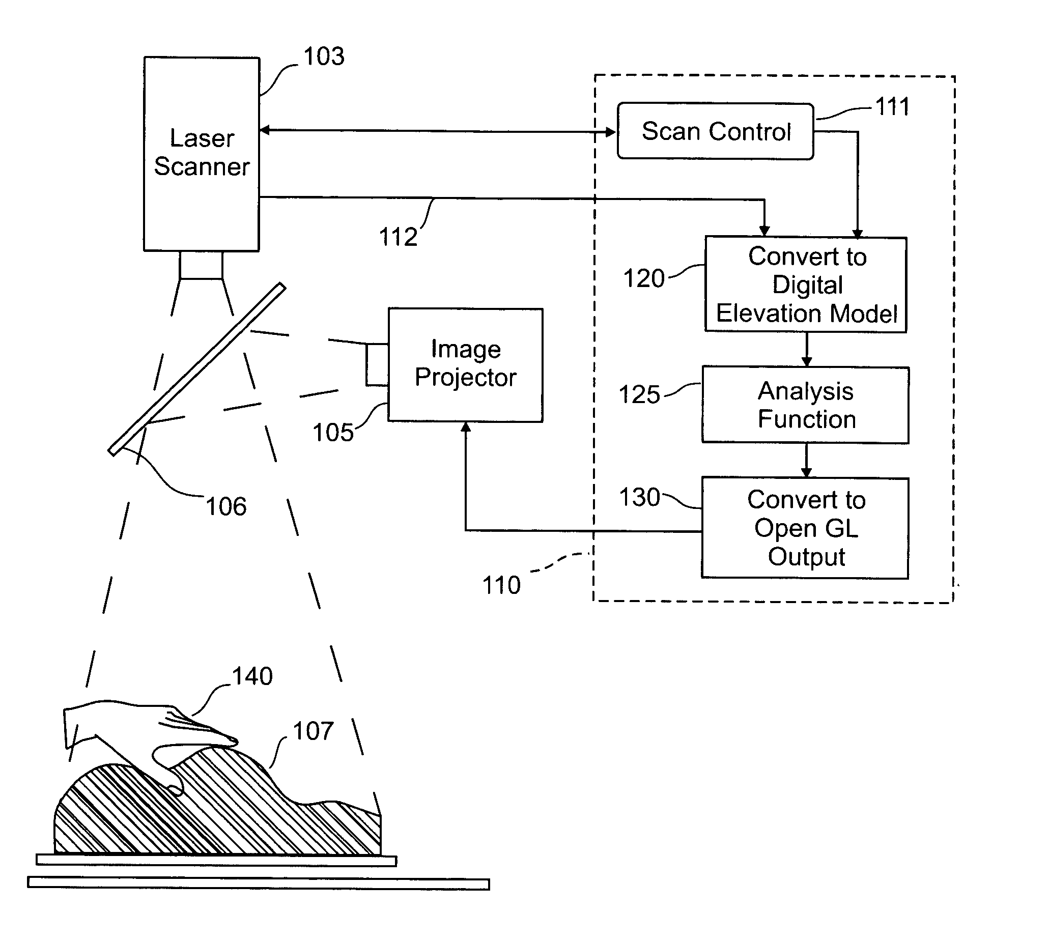
[0027] The preferred embodiment of the invention performs real-time computational analysis of landscape models. It is to be understood, however, that the techniques employed are more broadly applicable to a variety of uses which benefit from the availability of a human-computer interface that enables the user to define geometric forms by manipulating a deformable surface to change its shape, and to directly visualize computed result data that is projected in real time onto the surface of the deformable surface. In addition to landscape design, the interface can be used to advantage in medical imaging, free-form architectural construction, fluid dynamics modeling, and many other domains that require an understanding of special and temporal factors manifested in three dimensional space.

[0028] When applied to the problem of landscape design, the specific embodiment described below, which is called “Illuminating Clay,” allows a landscape designer to modify the topography of a clay land...


PUM


Abstract

An interface that allows a user to model and analyze the properties of three dimensional surface and the regions surrounding such surfaces. The user manipulates a deformable physical modeling material that defines the geometry of a surface. A position sensor such as a laser scanner captures position data specifying the geometry of the surface. A processor processes the geometry data using a selected analysis function to produce result data representing computed characteristics of the surface or its surrounding region. The result data projected as an image onto the deformable surface. The interface permits the user to modify a surface geometry and directly visualize the characteristics of the modified geometry in real time.

Description

CROSS REFERENCE TO RELATED APPLICATIONS [0001] This application is a continuation in part of U.S. patent application Ser. No. 10 / 696,474 filed on Oct. 29, 2003 and claims the benefit of the filing date thereof. This application also claims the benefit of the filing date of U.S. Provisional Patent Application Ser. No. 60 / 463,273 filed Apr. 16, 2003, and further claims the benefit of the filing date of U.S. Provisional Patent Application Ser. No. 60 / 463,357 filed Apr. 17, 2003. The disclosures of each of the foregoing applications is incorporated herein by reference.FIELD OF THE INVENTION [0002] This invention relates to systems for interacting with spatial data and more particularly to systems for modeling physical forms such as landscapes and exploring their characteristics by computational analysis. BACKGROUND AND SUMMARY OF THE INVENTION [0003] Landscape engineering typically deals with large land areas and requires the input of several specialists. These include experts in earth ...

Claims


Application Information

Patent Timeline
Patent Type & Authority Applications(United States)
IPC IPC(8): G01B11/24G01B11/30G06F3/042G06T7/00G06T15/10G06T15/40G06T15/50G06T17/00G06T17/40G06V10/10G09G5/02
CPCG06F3/0425G06T19/00G06T2219/008G06K2209/40G06K9/20G06V10/10G06V2201/12
Inventor RATTIPIPER, BENJAMIN TARQUINN FIELDINGISHII, HIROSHI
Owner MASSACHUSETTS INST OF TECH
Why Eureka
Try Eureka